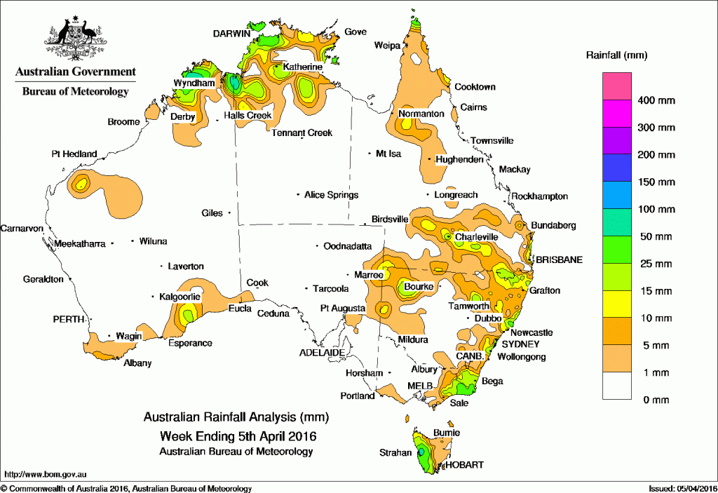
It was dry week for many parts of Australia with rainfall limited limited to the Kimberley and southwest of Western Australia, the Top End of the Northern Territory, the Cape York Peninsula, the Gulf Country and southern Queensland, northern and coastal areas of New South Wales, eastern Victoria and western Tasmania.
At the beginning of the week a surface trough with an embedded low pressure system in the Tasman Sea generated isolated storms across the far southeast coast of New South Wales and eastern Victoria. Meanwhile, an upper level cloud band brought light to moderate showers to northern New South Wales and southern Queensland.
A surface trough produced thunderstorms with moderate falls over northern parts of the Northern Territory and in the Kimberley districts of Western Australia with lighter falls reported in southern parts of Cape York Peninsula.
In the middle of the week, an extensive cloudband ahead of a vigorous cold front moved through the Great Australian Bight, bringing showers to western Tasmania. A surface trough extending from the Pilbara coast and through the northwest Kimberley in Western Australia produced showers and thunderstorms across the Kimberley; also on the Northern Territory/Western Australia border and eastern parts of the Top End.
Light to moderate showers continued across western Tasmania in a strengthening northwesterly airstream as a cold frontal system approached the State from the west.
In the last part of the week, isolated showers and thunderstorms were recorded near the Tiwi Islands and Kimberley coast and over the far north of Queensland’s Cape York Peninsula. An onshore flow produced moderate to heavy falls along the central New South Wales coast. A cloud band associated with a cold front brushed the southwest and brought light to moderate falls to the southern areas of Western Australia.
Weekly rainfall totals between 50 mm and 100 mm were recorded in the Kimberley and on the Northern Territory/Western Australia border, western Tasmania and on the central coast of New South Wales, with some locations recording totals in excess of 100 mm. The highest weekly total was 111 mm at Mount Read in Tasmania.
Rainfall totals between 25 mm and 50 mm were recorded in the Top End of the Northern Territory, the far north of Cape York Peninsula, the Gulf Country and southern districts of Queensland. Similar totals were recorded in parts of northern and coastal New South Wales, eastern Victoria, western Tasmania and small areas of southwest Western Australia.
Rainfall totals between 10 mm and 25 mm were recorded across the Top End of the Northern Territory, Cape York Peninsula, and the Gulf Country of Queensland, the Pilbara and southern Western Australia and across parts of the eastern Pastoral areas of South Australia.
Most of Western Australia, Northern Territory, eastern and inland Queensland, central and southern New South Wales, much of Victoria, eastern Tasmania and most of South Australia recorded little or no rainfall this week.
New South Wales and Australian Capital Territory
109 mm Sydney (Observatory Hill)
85 mm Sydney Botanic Gardens
79 mm Dover Heights (Portland St)
Victoria
85 mm Gabo Island Lighthouse
69 mm Whitlands (Burder’S Lane)
57 mm Point Hicks (Lighthouse)
Queensland
79 mm Horn Island
32 mm Ballandean Post Office, Noosaville
Western Australia
93 mm Kununurra Aero
61 mm Doongan
53 mm Theda
South Australia
7 mm Wirrabara Forest
3 mm Booleroo Centre, Yongala, Mannanarie
Tasmania
111 mm Mount Read
72 mm Queenstown (South Queenstown)
55 mm Zeehan (West Coast Pioneers Mu
Northern Territory
57 mm Majestic Orchids
48 mm Wagait Beach
44 mm Shoal Bay
More weekly rainfall totals:
- NSW/ACT totals click here
- Vic totals click here
- Qld totals click here
- WA totals click here
- SA totals click here
- Tas totals click here
- NT totals click here
Source: BOM


HAVE YOUR SAY