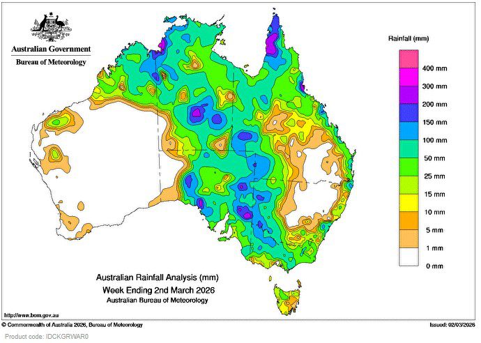
A slow-moving low pressure system and an inland trough, near-stationary over the south-east of the Northern Territory, produced widespread heavy rainfall over central Australia.
A monsoon trough and several tropical lows and troughs brought showers, rain and thunderstorms to large parts of northern Australia, including parts of Queensland’s North Tropical Coast.
 Weekly rainfall totals of 50 to 200 mm, with locally higher falls, were recorded across broad areas of northern Australia, much of the southern Northern Territory, south-western Queensland, western New South Wales and most of South Australia.
As the low pressure system moved down through South Australia, the system interacted with a cold front and associated trough that brought rain, showers and isolated thunderstorms to the south-east of the state and into western Victoria.
Weekly rainfall totals of 50 to 150 mm were recorded across southern and south-eastern South Australia, in northern and central Victoria north of the Dividing Range and parts of coastal New South Wales.
Weekly totals of 25 to 50 mm were recorded in north-western Tasmania, parts of central and eastern Victoria, and south-eastern New South Wales.
Minor to major flooding, with widespread flood warnings and watches, continues across Queensland, parts of the Northern Territory, much of South Australia, western New South Wales and Victoria, with some regions also experiencing flash flooding.
The highest weekly total (at a Bureau gauge) was 371.2 mm at Gairloch in Queensland.
The highest daily total (at a Bureau gauge) was 239.2 mm at Hawkins Creek in Queensland in the 24 hours to 9 am on 2 March.
HAVE YOUR SAY