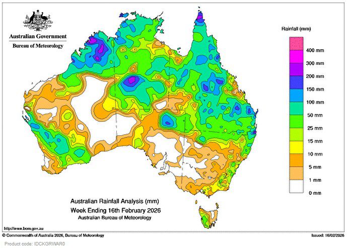
SEVERE Tropical Cyclone Mitchell (21U) made landfall in Western Australia as a tropical low east of Shark Bay on 10 February, and continued to move inland, bringing widespread rain, showers and thunderstorms to large parts of the south-west.
Weekly rainfall totals of 25 to 150 mm, with isolated heavier falls, were recorded across much of south-western Western Australia.
 Surface troughs, combining with tropical moisture, brought severe thunderstorms, heavy rainfall and isolated flash flooding to parts of Queensland, including the Wide Bay and Burnett, and Central Highlands and Coalfields districts.
Weekly rainfall totals reached up to 200 to 300 mm in far northern parts of Western Australia, the central Northern Territory, and parts of Southeast Coast in Queensland.
Weekly rainfall totals of 50 to 200 mm were recorded across much of northern Australia, as well as far northern New South Wales and north-eastern South Australia.
A cold front crossing the Great Australian Bight, linked up with the remnants of Ex-TC Mitchell to bring a band of showers and isolated thunderstorms to south-eastern Australia, including snow to elevated regions in Tasmania.
Weekly rainfall totals of 10 to 50 mm were recorded across western Tasmania, and eastern Victoria and New South Wales.
The highest weekly total (at a Bureau gauge) was 310.2 mm at Mount Winifred in Western Australia. The highest daily total (at a Bureau gauge) was 190.0 mm at Surbiton Station in Queensland in the 24 hours to 9 am on 13 February.
HAVE YOUR SAY