SEVERE Tropical Cyclone Megan made landfall as a Category 3 system on 18 March on the south-western coast of the Gulf of Carpentaria, south-east of Port McArthur in the Northern Territory. The system was downgraded to a tropical low on the 19th, as it moved westwards across the interior of the Northern Territory towards Western Australia.
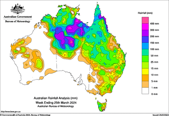
There was widespread rainfall and isolated thunderstorms across parts of northern Australia throughout the week and this was associated with monsoonal activity, while a series of troughs moved across southern, western and eastern parts of the country bringing mostly moderate rainfall totals.
Weekly rainfall totals greater than 200 mm were recorded across western, central and eastern parts of the Northern Territory and along the north-eastern coast of Queensland, with some areas receiving more than 300 mm.
Weekly rainfall totals of 100 to 200 mm were recorded across central and southern areas of the Northern Territory, an isolated pocket of the Kimberley district of Western Australia and areas of western and northern Queensland.
Weekly rainfall totals of 50 to 100 mm were recorded in the Top End and southern areas of the Northern Territory, north-eastern parts of Western Australia, western, northern and isolated pockets of central Queensland, and parts of western Tasmania.
The highest weekly rainfall total was 387.0 mm at Cape Flattery in Queensland.
The highest daily rainfall total during the week was 289.0 mm at Centre Island (Northern Territory), in the 24 hours to 9 am on 19 March.


HAVE YOUR SAY