COLD fronts crossed southern Australia at the start and end of the week, bringing damaging winds, storms, heavy rain and in the south-east a risk of renewed river level rises.
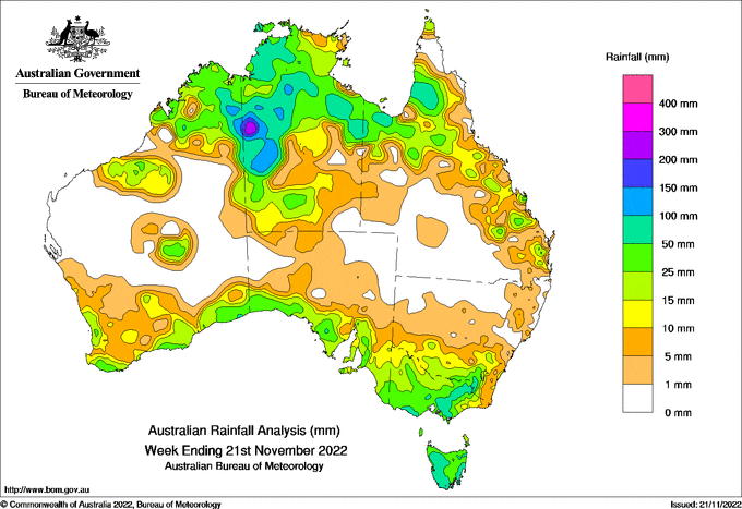
Weekly rainfall totals of 50 to 100 mm, with higher totals in alpine areas, were recorded in central and north-eastern Victoria, the New South Wales South West Slopes district and across much of Tasmania.
 There were thunderstorms across much of the tropics during the week, particularly in the Northern Territory Gregory district.
Weekly rainfall totals of 50 to 150 mm were recorded across the Northern Territory Daly, Gregory and Carpentaria districts, adjoining areas of the Western Australia Kimberley district and parts of the Gulf Country and southern Cape York Peninsula in Queensland.
Weekly totals of 25 to 50 mm were recorded along the Western Australian south coast, in the South Australian agricultural areas and across most of western Victoria.
The highest daily total, at a Bureau gauge, was 93.0 mm at Birrindudu (Northern Territory Gregory district) to 9am 17 November and highest weekly total was 186.2 mm at Thredbo Village (New South Wales).
Most areas of the Northern Territory and Queensland have reached their Northern Rainfall Onset (at least 50 mm since 1 September) earlier than usual, in many areas by more than a month.
Major flooding continues along the Murray River and in many rivers in inland New South Wales.


HAVE YOUR SAY