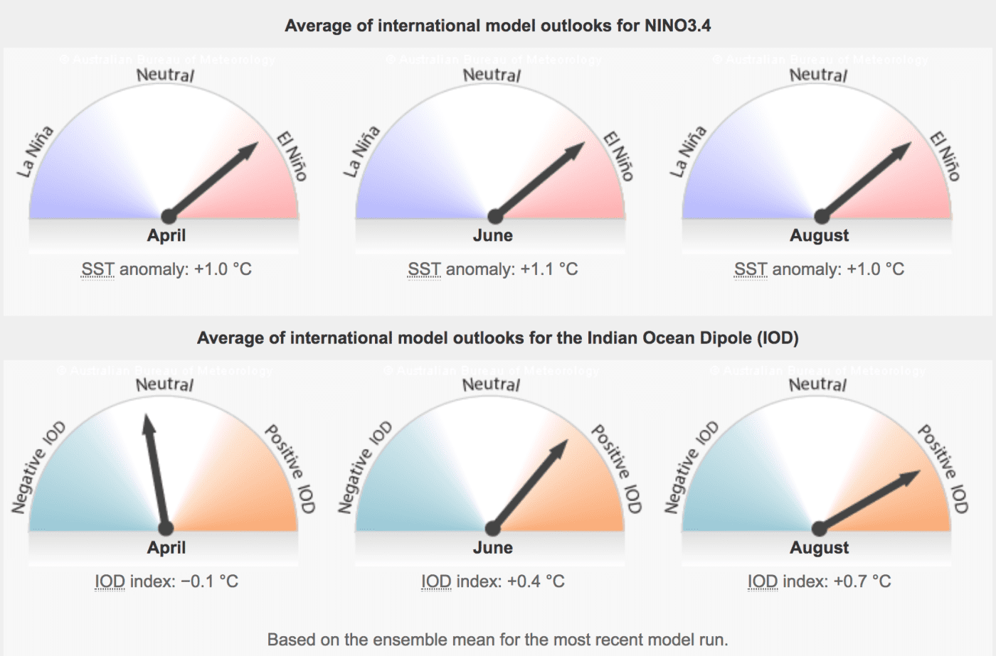
The arrows on the dials indicate the combined average of monthly outlooks from a survey of international global climate models. Source: BOM.
The Bureau of Meteorology’s El Niño–Southern Oscillation (ENSO) is currently set at neutral.
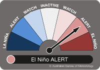 However, the Bureau said today it has moved its ENSO Outlook from ‘WATCH’ to ‘El Niño ALERT’, saying the the chance of El Niño developing in 2019 had increased to approximately 70 percent, around triple the normal likelihood.
The BOM says Tropical Pacific sea surface temperatures have touched on El Niño thresholds for the past three weeks, while waters below the surface are also slightly warmer than average.
Signs of El Niño in the atmosphere are less clear. While values of the Southern Oscillation Index (SOI) are currently within El Niño bounds, the index is likely to weaken in the coming days. Large swings in the SOI are not uncommon during the southern hemisphere monsoon season. Additionally, trade winds have been closer to normal over the past fortnight after a period of weakened trades in the western tropical Pacific.
Most international climate models suggest sea surface temperatures in the central tropical Pacific Ocean are likely to remain at El Niño levels into winter. Sustained warmer than average ocean waters would increase the likelihood of coupling between the atmosphere and ocean, which would typically cause changes in Australian and global weather patterns. However, current outlooks have less skill for the period beyond May, and therefore predictions for the latter months should be viewed with some caution.
El Niño typically brings drier than average conditions for eastern Australia during winter–spring, and warmer days across southern Australia. During the autumn months, the influence of El Niño tends to be weaker, but can bring drier conditions to southern Australia.
The Indian Ocean Dipole (IOD) has little influence on Australia from December to April. Current outlooks suggest the IOD is likely to remain neutral for the remainder of the austral autumn, but indicate a positive IOD may form later in winter. A positive IOD typically means drier than average conditions for southern and central Australia during winter-spring.
Rash prediction. There will be an El Nino, peaking 26 December, ending with La Nina 20 January. Barycentre up for El Nino under western Pacific, eclipses show the track. All ENs and LNs now predictable – just basic geophysics. 30 years work, revising plate tectonics. BOM stone deaf. You? 07 3289 4470
Peter Spencer Ravenscroft, geo. p.s.ravenscroft@gmail.com
I wish forecasters would get it right. Bring back Inigo Jones – he didn’t have the modern-day equipment you all have, yet he was far more accurate. What is going on with you lot today – are you just messing with our minds? You must be able to be more accurate.
Full names required for future reader comments, please Alison, as per our long-standing rules of engagement for reader comments. Click here to view the full statement. Editor
God help the poor farmers and the other rural sectors if the el nino effect does eventuate we are dry enough as it is .
I just wish all these weather forecasters would quietly slip into oblivion