 The wettest two-year period on record has set the stage for one of the most potentially severe bushfire seasons across the country in many years.
Abundant grass growth created by two consecutive La Nina events, and forecasts of a hot and dry summer ahead as a predicted El Nino returns, underpins the worse-than-normal fire outlook.
A lack of rain in the final weeks of winter and the onset of dry winds has already sparked an early start to this year’s fire season, with dozens of outbreaks reported across the country, including some which have burnt out thousands of acres of grazing country in north western Qld and western NSW.
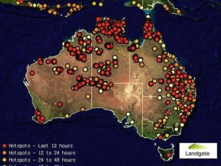
The above map of fire hot spots, current to this morning, highlights the widespread nature of the existing fire threat.
A fire season outlook released for Southern Australia by the Bushfire Co-operative Research Centre on Tuesday warns that the combination of heavier than usual fuel loads and a hotter, drier summer means Australia is potentially facing one of its worse bushfire seasons in years.
While extensive fires over the past 12 months have reduced fuel loads in some areas, fire potential is considered above-average for many areas from the east to west coast, as the outlook maps at the bottom of this page highlight.
The CRC has also forecast that Northern Australia will face higher than usual fire potential, particularly the significant areas that were not burnt last year.
“The above average forecast is due to the abundant grass growth from the high amount of rain from two strong La Niña events seen in the past two years across the eastern seaboard and South Australia," its report released on Tuesday said.
“Fuel moisture content within forests is still high, but this rainfall has continued to provide widespread vegetation growth in the grasslands, which remain a threat.”
Tuesday's outlook contained the following assessment of fire threats for each major region of South Australia:
WA/SA: In Western Australia, above average fire potential is expected across the South West, Mid-West, Desert and Nullarbor regions.
Above average fire activity is predicted in the western part of the West Coast, North East Pastoral and North West Pastoral districts of South Australia due to abundant and continuous grass fuels.
Qld: Current grass fuel levels throughout Queensland are considered abundant and continuous. As a consequence, fast running, high intensity grass fires can be expected over most of the state, with particular concerns for southern and western Queensland.
NSW: In New South Wales, above normal fire potential has been assessed for grassland areas west of the Great Dividing Range, the Tablelands, the Upper Hunter and the far west.
Above normal fire potential is predicted in the Monaro region and Murrumbidgee corridor of the ACT and south eastern New South Wales.
Vic: Victoria is predicting an average fire season, although key grassland areas authorities are monitoring include the Mallee, Wimmera and the South West.
Tas : Tasmania is expecting normal to below normal potential is expected for the fire season up until the New Year. Large fires may be possible in grasslands in the late summer.
Detailed forecasts for each state and teritory from the Bushfire CRC’s outlook for Northern and Southern Australia, released in late June and late August respectively, are as follows:
Western Australia
Kimberley: Overall, the bushfire potential for the Kimberley is average, but there are a number of areas that have above-average potential. The Kimberley area has been subject to high rainfall in the last six months and this has resulted in significant and widespread grass growth across the region. This assessment is mindful of the increased prescribed burning planned across the region, but the rainfall and consequent fuel loads are significant.
Pilbara/Northern Goldfields: in general, rainfall across the Pilbara has been average or above average, but less than the last calendar year. due to a few large fires in the pastoral grass fuel areas last year, average rainfall and the fuel type, the outlook potential is for an average season, with a number of areas being above average. This is in the general area from the coast to the area west of Newman/Nullagine.
Rainfall across the rest of the Pilbara and the Northern Goldfields (mainly east of Newman) has been above average, but when considering the fuel type, load and structure, it is expected to be an average bushfire season.
Southern WA: Iin general, above average fire potential is expected across the Mid-West, Desert and Nullarbor regions. This as a consequence of high fuel loads from extensive rainfall, resulting in very high annual grass growth.
This assessment is mindful of the increased prescribed burning planned across these regions, particularly the Nullarbor.
In the south West, the bushfire potential is expected to be above average as a consequence of reduced rainfall, soil moisture deficit and high fuel loads. Prescribed burning operations have also been hampered because of the weather.
In the Wheat Belt, average fuel loads are anticipated from the average rainfall and annual grass growth that has occurred across the region.
Northern Territory
Overview: There are three areas of above-average fire potential in the Northern territory. The north-west of the top end has increasing amounts of Gamba grass fuels and limited fire mitigation opportunities. The Gulf region had relatively low fire impacts in 2011 followed by above-average rainfall and reduced management and mitigation capacity in 2012. The Alice springs area extending to the south-west corner of the Northern territory is a mix of high fuel areas unburnt in 2011 and proportions with rapid pasture recovery; especially the areas dominated by Buffel grass, which will create fire management challenges in 2012.
Regional summary: The south-western top end receives reliably high wet season rainfall and the mix of tropical grasses and an expansion of Gamba grass into this area creates large tracts of high and continuous fuel loads. The large rivers, and many creeks and wet areas, restrict access for early dry season fire management. The result is most prescriptive fire management has limited effect and is later than desired.
Until land managers can manage fire earlier, the area will continue to be dominated by hot and late dry season fires and the rating of above-average fire potential.
The central Gulf area of the Savannas Fire Control region received above-average rainfall this year, and fuel accumulation is estimated at six tonnes per hectare. There have been recent changes in the management styles of the pastoral lands that have had significant fire management effects. Many stations now release staff after the mid to late dry season muster, and leave the property with caretakers that rarely have the experience, knowledge or resources to manage bushfires.
The bushfire seasonal assessment is above average – fire potential reflects the reduced capacity of the region to respond and contain bushfires. The far western Victoria River Downs area of the Savannas Fire Control region has higher than average fuel loads this year and an above-average fire potential. it is linked to the associated bioregion extending into Western Australia and both are expected to experience more bushfires than the surrounding fuel types.
The extensive fires in Central Australia during 2011 have reduced the fire potential across the majority of the southern Northern territory, especially in the Tanami and Simpson deserts. The south-west corner of the Northern territory, extending into South Australia and Western Australia, was not affected by fire in 2011 and has had sufficient rainfall to increase the fire potential to above average. The developing mitigation capacity on the APY lands is not expected to achieve sufficient outcomes in 2012 to reduce the fire potential. The area surrounding Alice Springs and connecting to the south-west Northern territory area has a mix of fuel loads with a significant proportion that was unburnt in 2011.
Within the landscape matrix are areas of productive country that received above average rainfall after the 2011 fires to promote good pasture growth. during cool conditions, these areas will be a challenge for mitigation efforts to achieve effective management burns, but during the summer period of high fire danger they are expected to carry fires.
The remainder of the Northern territory has a diversity of fuel types and fuel loads, including some areas left unburnt from the 2011 season. The fuel loads range from two to 11 tonnes per hectare. despite the forecast of an el Niño and its associated late start to the wet season, the assessment for these extensive areas is an average fire potential due to the effectiveness of the mitigation and management efforts of landholders, and strategic and opportunistic fuel reduction.
South Australia
Above average fire activity is predicted in the western part of the West Coast, North East Pastoral and North West Pastoral districts due to abundant and continuous grass fuels. This is a result of the previous season’s growth remaining and the rainfall received, linked with conducive growing conditions.
For the remainder of the state, including the southern settled areas, the most likely scenario is for near average levels of fire activity.
Resource implications of an above average fire danger season may see the need for firefighting resources for a longer period of time being committed to incidents. The North east and North West Pastoral areas may pose resourcing issues during this fire season, as they did last season when firefighters and aircraft were committed for lengthy periods.
The South Australian border with the Northern territory in the Simpson Desert has received above average rainfall. Conducive growing conditions have seen an abundance of growth, increasing the above average fuel loads from previous growing seasons.
Queensland
Queensland’s bushfire season is primarily influenced by long-term and seasonal short-term climate conditions and the relationship the climate has on vegetation.
A strong La Niña pattern in 2010 followed by a moderate La Niña in 2011 produced record rainfall that promoted a prolific increase in vegetation growth across the state. During January to April 2012 above-average rainfall continued to influence the vegetation growth profile.
Long-range climate models suggest that the current ENSO Neutral conditions may continue until late winter and there is a strong chance of an el Niño pattern forming during spring and into summer.
The rainfall outlook from June to August 2012 indicates more than a 60pc probability of above median rainfall across most coastal and inland parts with far western inland areas having a 50pc probability of median rainfall during the period.
The outlook also indicates average daytime maximum temperatures, but warmer minimum temperatures.
Current grass fuel levels throughout Queensland are considered abundant and continuous. Although Queensland has experienced slightly wetter than normal early winter conditions, August to date has seen below average rainfall and cooler temperatures with extensive frosts, especially in the western and central western parts of Queensland.
This contributed to a rapid increase in grassland curing, and general vegetation conditions in the south west of the state may indicate an early start to the bushfire season over a wide area.
Fast running, high intensity grass fires can be expected over most of the state. There are particular concerns for large grass fires in southern and western Queensland.
Woodlands with a grassy understorey may exhibit similar fire behaviour; however rates of spread may be slightly less than those of open grasslands. forest fires with a moderate intensity are expected early in the bushfire season and fire intensity is likely to increase during the later part of the season, especially if the season is prolonged. This is due to a drying soil moisture profile, an increasing forest fine fuel layer and the influence of warmer temperatures and dry north-west to south-westerly winds.
The areas assessed as being of above average fire risk are the grasslands and pastures of south western Queensland, which incorporates the areas from Stanthorpe and the Granite Belt district, north to Toowoomba, Dalby, Miles and Taroom, west to the South Australian border and south to the New South Wales border.
Low stocking levels and above average fuel loads have the potential to significantly increase fire activity in these areas.
All other areas are considered an average fire risk.
New South Wales
Above average rainfall over the state for much of the previous two years has resulted in heavy grass fuel loads throughout grassland areas.
These grassland areas include those west of the Great Dividing Range, the Tablelands, the Upper Hunter and the far west. Above normal fire potential has been assessed in these areas due to high grass fuel loads plus an increased likelihood of warmer and drier conditions for spring.
The fire potential is expected to be average for forested regions east of the Great Dividing Range due to average fuel moisture.
Australian Capital territory and South East New South Wales
Above average rainfall over the past two seasons has produced considerable grass fuel loads in areas where grazing has been low. Winter frosts and snows have increased curing rates in tableland and highland regions. These cured grasses, combined with expected low spring rainfalls associated with a weakly developing El Niño, are expected to result in above normal fire potential in the Monaro region and Murrumbidgee corridor.
Forest fuels are well saturated due to good lower level soil moisture and are expected to take some time to dry, especially in rugged landscapes. as a result average fire potential in these southern ranges and slopes is expected.
Victoria
Victoria is a fire prone environment; fires occur every year and are a part of the landscape. At this stage it is anticipated that Victoria will experience an average fire season, although it is important to note that fast running grass fires occur in any average Victorian season.
Key grassland areas that authorities are monitoring include the Mallee, Wimmera and the South West. This may be expanded over the coming months as growth patterns become established.
Over the past 12 months higher than average rainfall has occurred over the east of Victoria.
Soil and forest fuel conditions are consequently saturated in the east, making it too early for an accurate assessment of fire potential in Gippsland and the North east.
The expectation of warmer and drier conditions over the coming months will present ideal growing conditions for grass across Victoria.
This will be the main contributor to the fire hazard, beginning in the west.
Victorian fire agencies are concerned that this year’s early fire potential assessment as average may result in complacency among Victorian communities to the dangers of short-lived and destructive grass fires.
Tasmania
Normal to below normal potential is expected for the fire season up until the New Year. There is very little likelihood of large scale fires up to this time. Large fires may be possible in grasslands in the late summer due to retained thatch combined with expected spring growth.
The Moorlands are currently wet and as such the fire potential has been assessed as normal. Forest fuel availability will be limited unless serious rainfall deficiencies occur.
Click on below images view outlook for Northern and Southern Australia (shaded areas indicate above-normal fire potential) and existing fire hotspots across Australia.


HAVE YOUR SAY