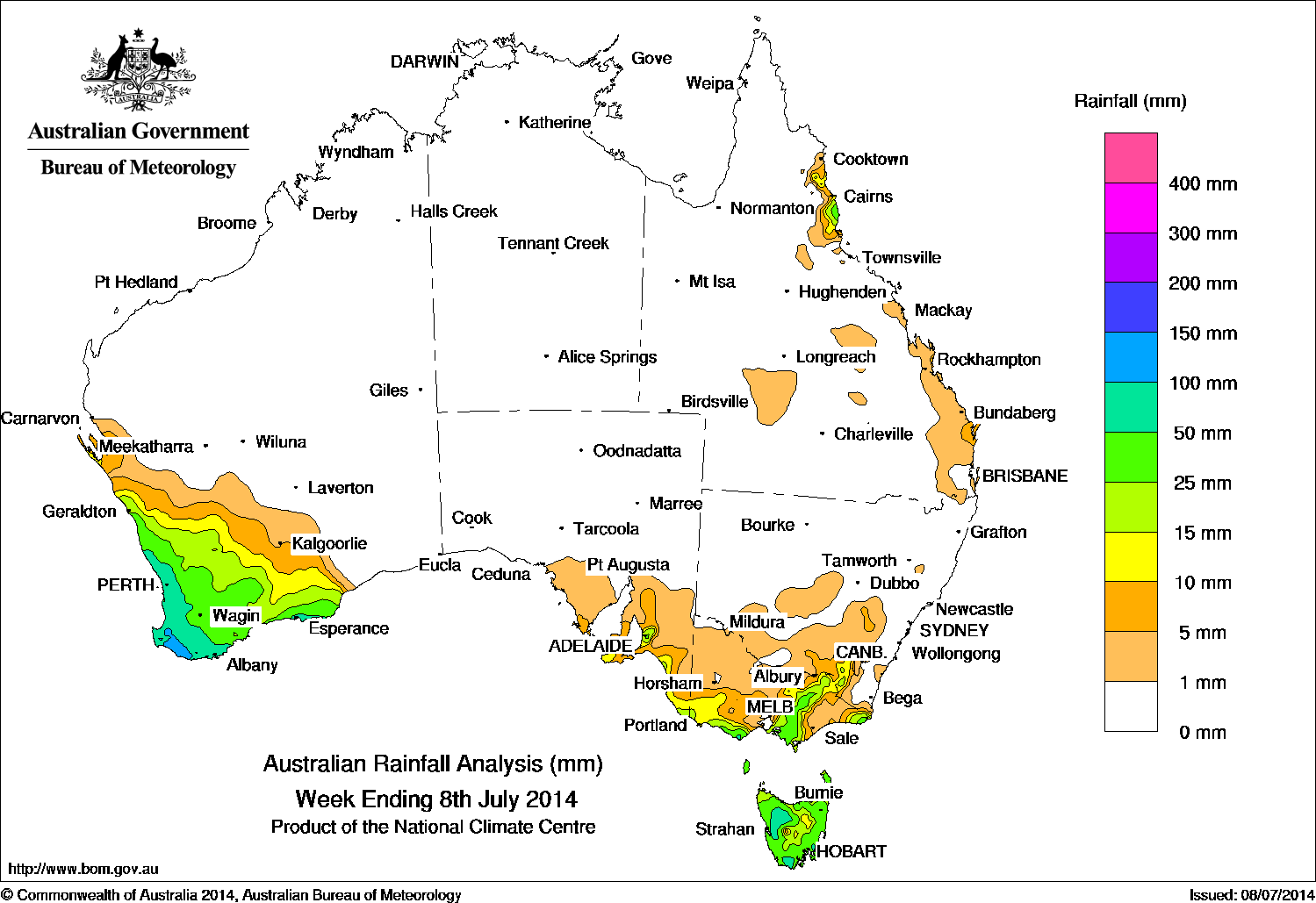
Rainfall recorded across Australia for the seven days to Wednesday, 8 July, 2014
Rainfall was recorded in the Southwest Land Division of Western Australia, southeastern South Australia, Victoria, the alpine region of NSW, Tasmania, and also in a small area of the tropical east coast of Queensland over the past seven days.
A cold front and associated low pressure system produced widespread rainfall in the Southwest Land Division of Western Australia at the start of the week before moving through the Great Australian Bight and Bass Strait, bringing showers to the southeastern mainland and Tasmania at mid-week.
A vigorous westerly flow and embedded cold fronts brought moderate to heavy rainfall and isolated thunderstorms to the Southwest Land Division of Western Australia later in the week, while a slow-moving complex low over the Tasman Sea and approaching cold front produced some showers with moderate falls in Tasmania and southern areas of Victoria towards the end of the week.
In the north, low clouds associated with onshore flow brought some moderate falls to the tropical east coast of Queensland at the start of the week.
Rainfall totals between 50 mm and 100 mm were recorded along the coastal strip of southwest Western Australia, with smaller areas recording totals above 50 mm in the Otways in Victoria and in the west, south and northeast of Tasmania. Falls in excess of 100 mm were recorded between Busselton and Albany in southwest Western Australia, with the highest weekly rainfall recorded at Pemberton with 132 mm.
Rainfall totals between 10 mm and 50 mm were recorded across most of the Southwest Land Division of Western Australia, the remainder of Tasmania, along the coast of southeastern South Australia and western Victoria, between West Gippsland and inland southeastern New South Wales, as well as the eastern tip of Victoria and south of Cairns on Queensland’s tropical east coast.
Highest weekly falls in each State
| State | Highest | 2nd Highest | 3rd Highest |
|---|---|---|---|
| WA | Pemberton (132 mm) (South Coast) |
Northcliffe (129 mm) (South Coast) |
Karri Valley Resort (127 mm) (South Coast) |
| NT | Alcan Minesite (1 mm) (Arnhem) |
Gove Airport (1 mm) (Arnhem) |
n/a |
| SA | Ashton Co-Op (45 mm) (East Central) |
Uraidla (42 mm) (East Central) |
Ashton (41 mm) (East Central) |
| Qld | Bingil Bay (39 mm) (Herbert) |
Innisfail (36 mm) (Herbert) |
South Johnstone Exp Stn (32 mm) (Herbert) |
| NSW/ACT | Cabramurra Smhea (48 mm) (Southwest Slopes) |
Perisher Valley (27 mm) (Snowy Mountains) |
Batlow PO (19 mm) (Southwest Slopes) |
| Vic | Point Hicks (121 mm) (East Gippsland) |
Wyelangta (98 mm) (West Coast) |
Beech Forest (68 mm) (West Coast) |
| Tas | Mount Wellington (92 mm) (Southeast) |
Mount Victoria (62 mm) (Northern) |
Longley (62 mm) (Southeast) |
Source: BOM