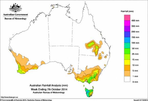
 Rainfall was recorded in southwest Western Australia, southern and eastern Victoria, southeast New South Wales, and the southern interior of Queensland.
At the beginning of the week, a cold front crossed Victoria and Tasmania, with an associated rainbandbringing moderate rainfall totals to western Tasmania, and light to moderate falls to parts of southern Victoria. Another weak front followed, crossing southern Tasmania bringing only light falls to the region.
During mid-week, a surface trough located over central Queensland triggered thunderstorm activity with isolated moderate rainfall being recorded in southern Queensland.
In the last half of the week, a cold frontal system crossed southwest Western Australia producing rainfall in the South West Land Division and adjacent Gascoyne and Goldfields districts. Further thunderstorm activity over southern Queensland brought moderate rainfall totals to the southern interior of Queensland and adjacent northern New South Wales.
Low level cloud in the south and west coasts of Western Australia associated with a moist, southwesterly airflow produced light to moderate rainfall in the State’s southwest. A strong cold front tracked through South Australia, Victoria and Tasmania at the end of the week, bringing moderate rainfall to elevated parts of the Victorian Alps, the Snowy Mountains and to northwest Tasmania.
Rainfall totals over 100 mm were reported in northwestern Tasmania. The highest weekly total was 154 mm at Mount Read in Tasmania.
Rainfall totals between 50 mm and 100 mm were recorded in northeastern and along the west coast of Tasmania, a small area of the Victorian Alps and the Snowy Mountains area in New South Wales.
Rainfall totals between 15 mm and 50 mm were recorded in southwest Western Australia, in parts of eastern and southern Victoria, in areas surrounding higher falls of southeastern New South Wales, and isolated parts of southern Queensland, and most of Tasmania away from the southeast.
Rainfall totals between 10 mm and 15 mm were recorded in southeastern Tasmania, and in areas surrounding higher falls through eastern and southern Victoria extending across the border into southeast South Australia, southeastern New South Wales, southern Queensland and along the southern and southwest coasts of Western Australia.
The Northern Territory, remaining parts of Western Australia, most of South Australia, northwest Victoria and most of Queensland except for the southern inland region recorded little or no rainfall for the week.
Highest weekly totals by state
| State | Highest | 2nd Highest | 3rd Highest |
|---|---|---|---|
| WA | Dwellingup (33 mm) (South Coast) |
Bungendore (30 mm) (Central Coast) |
Karnet (29 mm) (Central Coast) |
| NT | Darwin Hospital (13 mm) (Darwin-Daly) |
Leanyer (8 mm) (Darwin-Daly) |
Nil rainfall recorded |
| SA | Nangwarry Forestry (13 mm) (Lower Southeast) |
Mount Gambier (12 mm) (Lower Southeast) |
Kalangadoo (9 mm) (Lower Southeast) |
| Qld | Rosehill (25 mm) (Warrego) |
Listowel Downs (20 mm) (Central Lowlands) |
Munnaweena (20 mm) (Maranoa) |
| NSW/ACT | Thredbo Village (65 mm) (Snowy Mountains) |
Perisher Valley (62 mm) (Snowy Mountains) |
Thredbo (53 mm) (Snowy Mountains) |
| Vic | Mount Hotham (60 mm) (Upper Northeast) |
Boolarra South (55 mm) (West Gippsland) |
Walhalla (52 mm) (West Gippsland) |
| Tas | Mount Read (154 mm) (West Coast) |
Mount Victoria (119 mm) (Northern) |
Strathgordon Village (99 mm) (West Coast) |