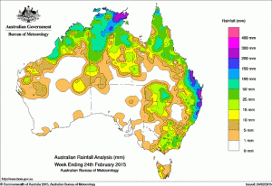
With two Tropical Cyclones simultaneously converging on the Northern Territory and Queensland last week, some heavy falls were received in the wake of both events, but some dry areas between both systems unfortunately missed much needed rain.
At the start of the week, eastern parts of Arnhem Land recorded heavy rainfall as tropical cyclone Lambecame established along a monsoon trough located over the northeast Gulf of Carpentaria. A surface trough extending from inland western Queensland, through New South Wales and central Victoria triggered thunderstorms and showers, producing moderate rainfall totals for parts of eastern Victoria and through central New South Wales, with light rainfall for southwest Queensland. A moist, onshore flow brought showers to the southeast Queensland and northern New South Wales coasts with light falls recorded through the area.
A low pressure system located on the monsoon trough, over the Coral Sea deepened and developed into tropical cyclone Marcia on the evening of the 18th. Light to moderate rainfall was recorded from Mackay in Queensland’s central coast down to Taree in the Mid North Coast district of New South Wales as tropical cyclone Marcia tracked southwest towards the Capricorn coast. Heavy falls continued in the Arnhem Land as tropical cyclone Lam crossed the coast of the Top End of the Northern Territory, while moderate falls were recorded across parts of the Kimberley in Western Australia.
Areas of heavy rainfall continued in the Top End, and also along the east coast and in adjacent inland districts south of St Lawrence in Queensland to around Lismore in New South Wales as both tropical cyclones Lam and Marcia made landfall early on the morning of the 20th. Thunderstorms also formed along a surface trough situated through Queensland’s interior producing light to moderate falls for southern inland Queensland and areas of northwest and central New South Wales.
In the last part of the week, a northwest monsoonal flow brought moderate falls to parts of northern Western Australia, the Top End and western Northern Territory as ex-tropical cyclone Lam tracked near the Western Australia and Northern Territory border. A moist and unstable airmass extended over the northern half of Queensland, with much of northeastern Queensland recording light to moderate falls. A pre-frontal trough extended from a low pressure system in central Western Australia through South Australia, western Victoria and along Tasmania’s west coast, with the cold front and trough crossing central Tasmania and Victoria at the end of the week. Light falls were recorded in parts of southeast South Australia and moderate rainfall totals were recorded in western Tasmania, parts of southern and eastern Victoria, and southeastern New South Wales as thunderstorms formed along the trough.
Rainfall totals in excess of 200 mm were recorded in Arnhem Land in the Northern Territory, parts of the central and southeast Queensland coasts, and along the northern New South Wales coast. The highest weekly total was 509 mm at Landsborough in Queensland.
Rainfall totals between 100 mm and 200 mm were recorded in areas surrounding higher falls across much of Arnhem Land, parts of the Darwin-Daly in the Top End, parts of the far north of Cape York Peninsula and the coastal strip from St Lawrence in Queensland down to the northern New South Wales coast.
Rainfall totals between 50 mm and 100 mm were recorded along the coast of the Kimberley district in Western Australia, parts of the Top End in the Northern Territory, isolated areas of the Cape York Peninsula and southern inland Queensland, a small area of the Snowy Mountains and most of northeastern New South Wales.
Rainfall totals between 10 mm and 50 mm were recorded in isolated areas of Western Australia in the Gascoyne, Pilbara and Central West districts, and surrounding higher falls in the Kimberley district extending into the northern half and eastern Northern Territory, parts of the Gulf Country, the Cape York Peninsula, along eastern Queensland including some adjacent inland districts, southern inland Queensland and across the border into northwestern New South Wales, most of northeastern and southeastern New South Wales, the eastern half of Victoria and in southwest and a small part of northeastern Tasmania.
Much of central and southern Western Australia, most of the southern quarter of the Northern Territory, most of South Australia, parts of southwest and central inland Queensland, western Victoria, and the southwest and central northern parts of New South Wales recorded little or no rainfall for the week.
Heaviest rainfall totals in each State:
| State | Highest | 2nd Highest | 3rd Highest |
|---|---|---|---|
| WA | Mandora (91 mm) (De Grey) |
Theda (85 mm) (North Kimberley) |
Broome Airport (83 mm) (West Kimberley) |
| NT | Nhulunbuy (262 mm) (Arnhem) |
Gove Airport (245 mm) (Arnhem) |
Yirrkala Tropical Gardens (236 mm) (Arnhem) |
| SA | Hamley Bridge (9 mm) (East Central) |
Arno Bay (7 mm) (Western Agricultural) |
Watervale (7 mm) (Lower North) |
| Qld | Landsborough (507 mm) (Moreton) |
Beerburrum (490 mm) (Moreton) |
Maleny (460 mm) (Moreton) |
| NSW/ACT | Boat Harbour (Rous River) (290 mm) (Upper North Coast) |
Bowra Sugarloaf (281 mm) (Lower North Coast) |
Rosebank (Repentance Creek) (269 mm) (Upper North Coast) |
| Vic | Falls Creek (Rocky Valley) (58 mm) (East Gippsland) |
Bullumwaal (51 mm) (East Gippsland) |
Dellicknora (49 mm) (East Gippsland) |
| Tas | Lake Margaret (22 mm) (West Coast) |
Lucaston (Bakers Creek) (20 mm) (Southeast) |
Queenstown (17 mm) (West Coast) |
Source: BOM

