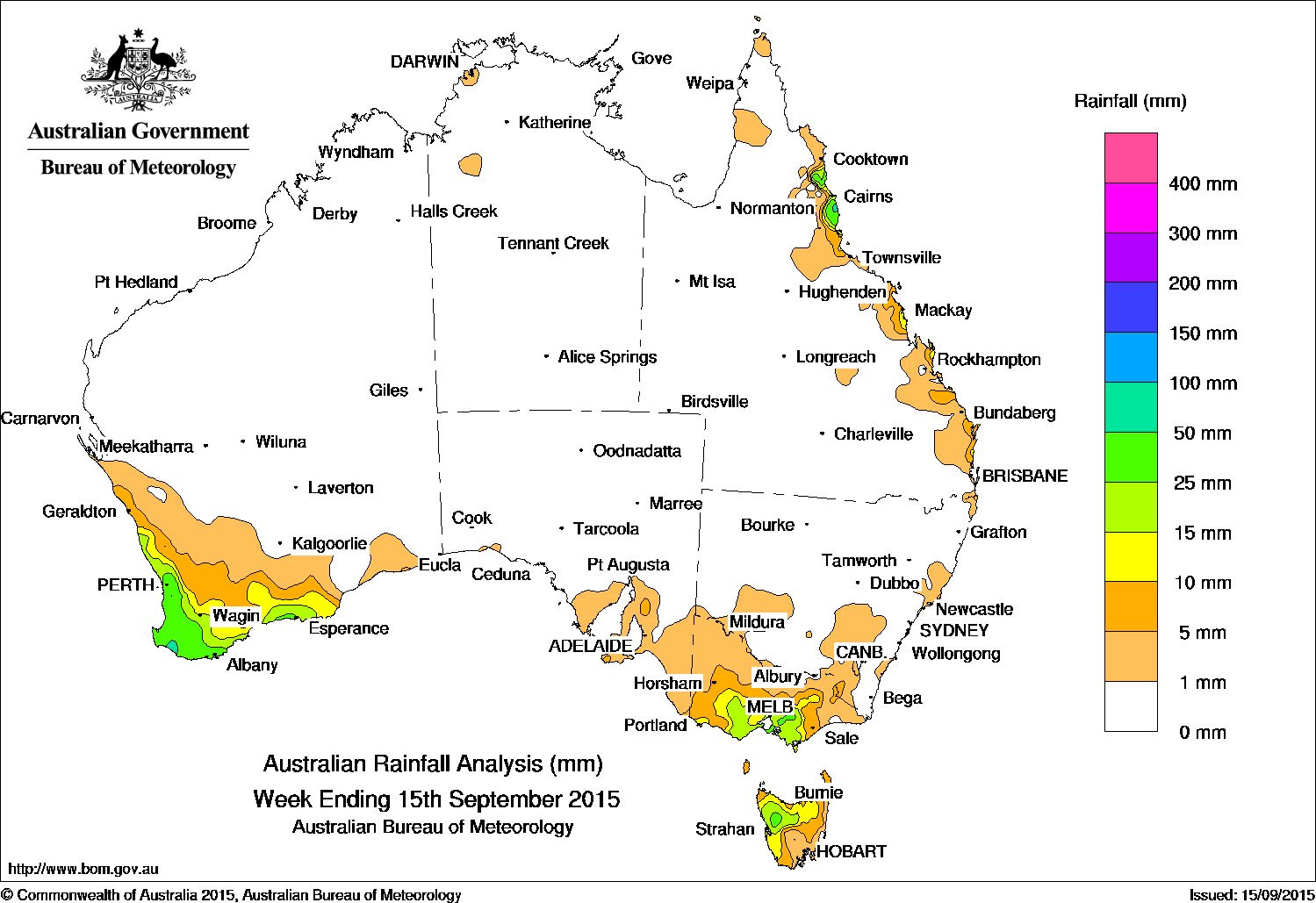
 In an otherwise very dry week for most of the continent, the highest rainfall totals of 50mm plus were confined to a small area in far southwest Western Australia.
Falls between 25mm and 50mm were recorded in the southwest and along the south coast of Western Australia, in small areas of central southern Victoria, northwest Tasmania, and in the north tropical coast of Queensland.
Rainfall of 10 mm and 25 mm was recorded in an area southwest of a line from Jurien Bay to Bremer Bay in southwest Western Australia; in large parts central and southern Victoria; in Tasmania along the west coast and much of the north; and in isolated pockets along Queensland’s east coast.
Remaining parts of Western Australia away from the southwest and southern coast; nearly all of the Northern Territory, South Australia and New South Wales; northern and far eastern Victoria; and most of Queensland except pockets along the east coast recorded little or no rainfall this week.
At the start of the week, a weakening low pressure system east of Tasmania and the remnants of a surface trough extending into Victoria brought light rain to southeastern South Australia, western and central Victoria, parts of southern New South Wales and western Tasmania. Meanwhile, a surface trough extending from the Gulf Country, through central Queensland and down to northern New South Wales, produced showers with moderate rainfall totals in parts of Queensland’s north tropical and Capricornia coasts. Light falls continued along pockets of Queensland’s east coast throughout the week due to a moist, onshore southeast to easterly airflow as high pressure dominated central Australia. .
Light to moderate rainfall totals was recorded in the southwest of Western Australia following the passage of a series of frontal systems that tracked eastwards during the week. Towards the end of the week, several low pressure centres developed along a surface trough in the Great Australian Bight as a front, brought light rainfall to a large part of the South West Land Division, then across most of the South and South East Coastal districts.
The low intensified as it moved into the Southern Ocean with the associated cold front and pre-frontal trough bringing moderate rainfall totals to central southern Victoria and northern Tasmania, and light falls to much of the remaining parts of Victoria, across western and northern Tasmania and southeastern South Australia at the end of the week.
Highest weekly totals in each State:
New South Wales and Australian Capital Territory
20 mm Ginninderra
17 mm Adelong
13 mm Mooral Creek
For more NSW/ACT totals click here
Victoria
40 mm Haines Junction (Mount Sabine)
37 mm Ferny Creek
32 mm Mornington
For more Vic totals click here
Queensland
61 mm Tully Sugar Mill
58 mm Innisfail
45 mm Tree House Creek
For more Qld totals click here
Western Australia
73 mm Karri Valley Resort
63 mm Huntly
57 mm Jarrahwood
57 mm Karnet
For more WA totals click here
South Australia
24 mm Bridgewater
22 mm Hallett
12 mm Clare (Neagles Rock)
For more SA totals click here
Tasmania
43 mm Mount Read
26 mm Zeehan
24 mm Lake Margaret Power Station
For more Tas totals click here
Northern Territory
7 mm Channel Island
4 mm The Chase
3 mm Charles Point
For more NT totals click here
Source: Bureau of Meteorology