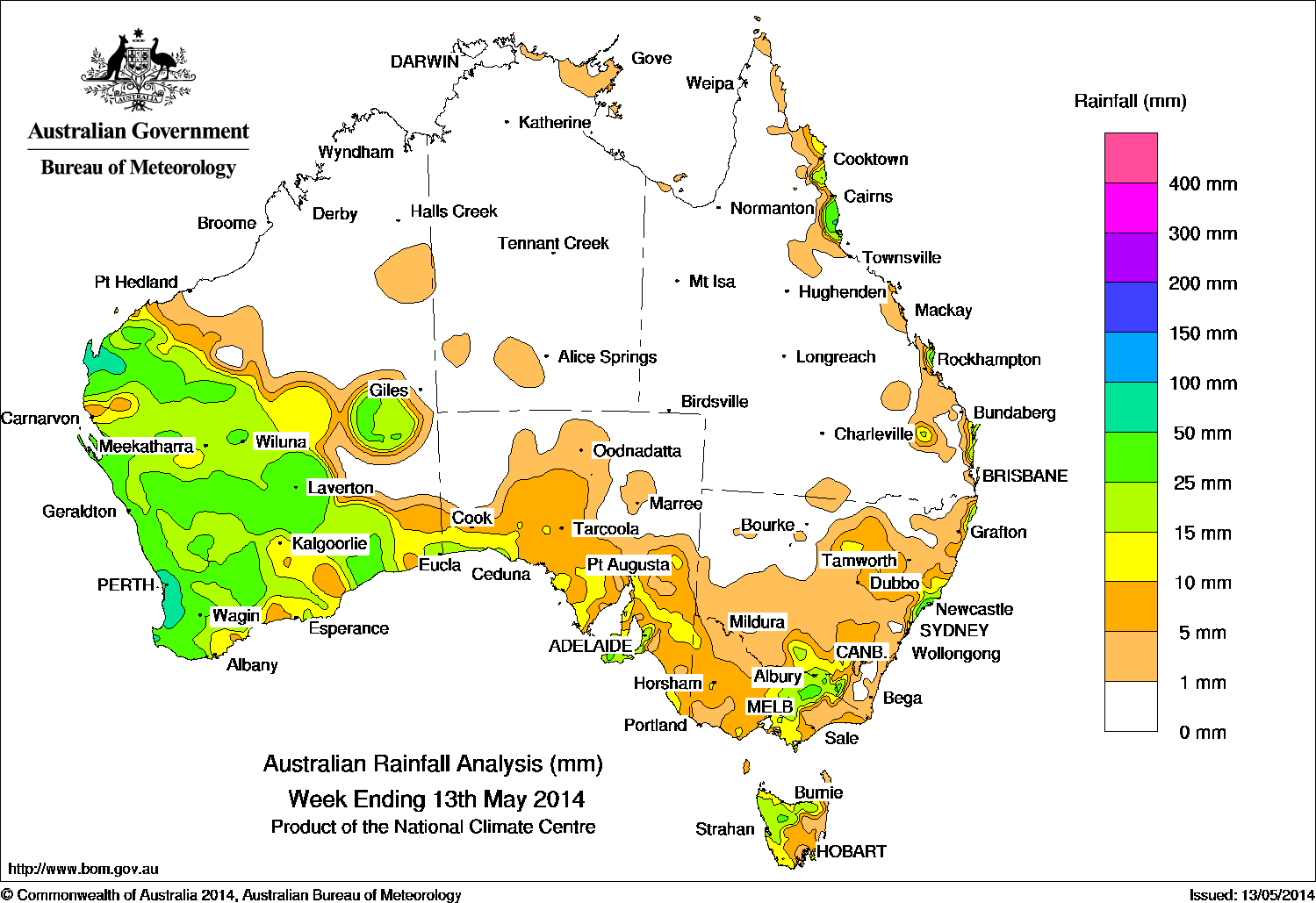
Rainfall recorded over the past seven days. Click on image to view in larger format.
Rainfall was recorded mainly in southern Australia over the past seven days.
The Northern Territory, northern Western Australia, most of inland Queensland west of the Great Dividing Range, inland South Australia and northwestern New South Wales received little to no rainfall.
Early in the week strong cold front with an associated cloudband moved across Western Australia and extended from the northwest of the continent through to western South Australia. Locally moderate to heavy falls were recorded in the western Gascoyne area and through most of the South West Land Division of Western Australia.
The frontal system moved across southeastern states, and stretched into the Southern Ocean. A broad cloudband associated with this system, extending from South Australia into New South Wales, Tasmania and Victoria, brought light to moderate falls.
A surface trough lying through the Queensland interior generated isolated thunderstorms near the central and northeast coasts of New South Wales along with some very isolated thunderstorms over the northern tropics. The surface trough extended along the east coast interior and linked to a cold front over the Southern Ocean, bringing moderate falls to the southeastern mainland, and Tasmania.
A firm ridge of high pressure extended across Queensland from a strong high near Tasmania and brought moist onshore flow to the far north tropical coast, along with light showers to the New South Wales central coast at the week’s end.
Rainfall totals between 15 mm and 100 mm were recorded across most of southwestern Western Australia, exposed parts of the South Australian coastline, elevated areas of the North East district of Victoria and the Snowy Mountains, the New South Wales central coast and along the north tropical and Capricornia coast of Queensland.
| State | Highest | 2nd Highest | 3rd Highest |
|---|---|---|---|
| WA | Bickley (97 mm) (Central Coast) |
Learmonth Airport (95 mm) (Fortescue) |
Roleystone (90 mm) (Central Coast) |
| NT | Cape Wessel (21 mm) (Arnhem) |
North East Island (10 mm) (Arnhem) |
Milingimbi (5 mm) (Arnhem) |
| SA | Parawa (71 mm) (East Central) |
Parndana (Turkey Lane) (69 mm) (Kangaroo Island) |
Parawa (Sharon) (52 mm) (East Central) |
| QLD | Tully (91 mm) (Herbert) |
Double Island Point (71 mm) (Moreton) |
Sandy Cape (66 mm) (Moreton) |
| NSW/ACT | Newcastle (82 mm) (Hunter) |
Nelson Bay (Nelson Head) (61 mm) (Hunter) |
Norah Head (59 mm) (Hunter) |
| Vic | Falls Creek (42 mm) (Upper Northeast) |
Lima East (Charnwood) (36 mm) (Lower Northeast) |
Mount Hotham (34 mm) (Upper Northeast) |
| Tas | Mount Read (41 mm) (West Coast) |
Targa (Mountain Views) (39 mm) (Northern) |
Mount Victoria (34 mm) (Northern) |
Source: Bureau of Meteorology