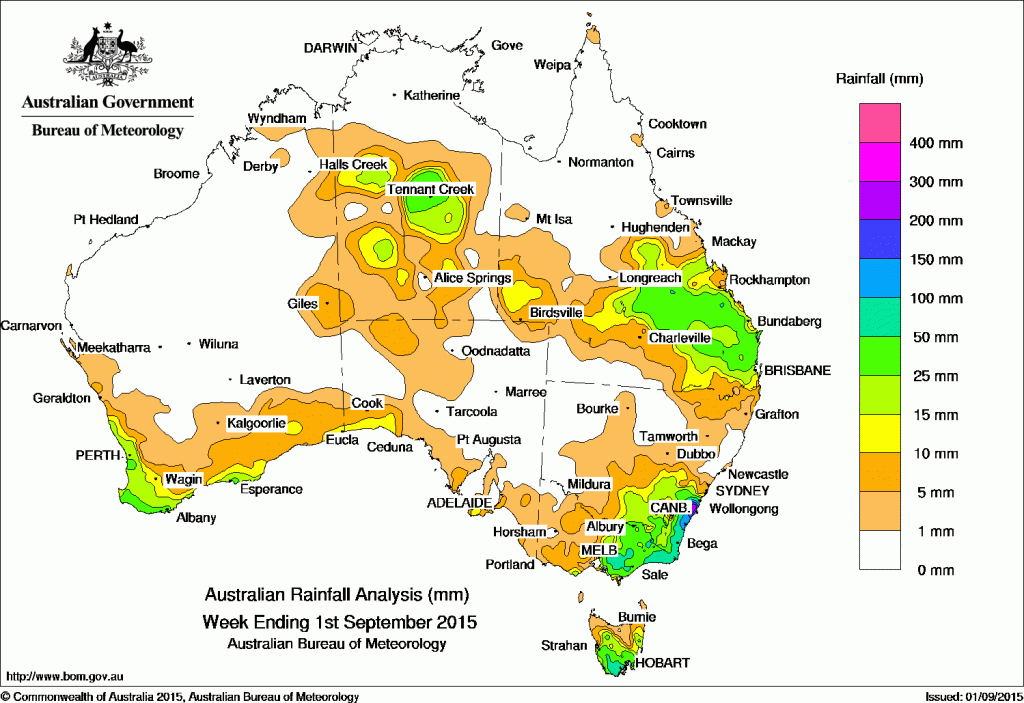
 Parts of Southern and Central Queensland, south eastern New South Wales and Victoria, the central Northern Territory, southern and northwestern South Australia and south coastal regions of Western Australia received rainfall over the past seven says.
Rainfall totals between 50 mm and 100 mm were recorded in parts of the south coast of New South Wales, East Gippsland and central Victoria, southern Tasmania, and in small areas of central and southeastern Queensland. Rainfall totals in excess of 100 mm were recorded on the Illawarra coast, with the highest weekly total of 310 mm at Kangaroo Valley in New South Wales.
Rainfall totals between 10 mm and 50 mm were in the southwest and south coast of Western Australia; the southwest coast of South Australia; central and southern parts of the Northern Territory; much of central and southeastern Queensland and an area of the southwest; southeastern New South Wales; eastern Victoria; and in most of Tasmania except parts of the north.
At the start of the week, a small low pressure system deepened off the New South Wales Coast near the Illawarra, producing heavy rainfall in the Illawarra and South Coast districts as the system tracked southward as an East Coast Low. Light rain also fell across much of northeastern Victoria.
During the early part of the week, an upper level trough and jet stream generated a cloudband over central Australia, producing moderate rainfall totals in central and southern parts of the Northern Territory. Meanwhile, thunderstorms formed along a surface trough that extended from the Gulf Country to the central coast of New South Wales, with moderate rainfall totals recorded across central and southeastern Queensland. Moderate falls continued through central parts of the Northern Territory into the middle of the week due to a middle level disturbance over central Australia.
By the middle of the week the East Coast Low had moved over the Tasman Sea, becoming a slow-moving broad, complex low. This system directed a southeasterly airstream over Victoria and Tasmania, resulting in moderate rainfall across central and northeastern Victoria, parts of southeastern New South Wales and southeastern Tasmania.
At the end of the week, a surface trough and upper level disturbance over southern Queensland produced moderate falls in central and southeastern Queensland.
Several cold fronts crossed southwest Western Australia at the end of the week. The first pair generated light to moderate rainfall totals around Perth and the coastal southwest, with a later front producing moderate falls along south coast of Western Australia on the last day of the week.
All of Western Australia away from the south and southwest, most of South Australia, the Top End, northern Queensland, and western and northern New South Wales recorded little or no rainfall.
Highest weekly totals by State:
New South Wales and Australian Capital Territory
310 mm Kangaroo Valley (Main Rd)
309 mm Beaumont (The Cedars)
272 mm Hampden Bridge (Kangaroo River
For more NSW/ACT totals click here
Victoria
102 mm Genoa (Fools Haven)
92 mm Mount Wellington
91 mm Walhalla
For more Vic totals click here
Queensland
85 mm Juanita
76 mm Sunshine Coast Airport
59 mm Goomboorian
For more Qld totals click here
Western Australia
55 mm Mundaring
40 mm Northcliffe
40 mm Mandurah
40 mm Dwellingup
For more WA totals click here
South Australia
16 mm Parndana AWS
15 mm Kangarilla (Saddlebags)
13 mm Bridgewater
For more SA totals click here
Tasmania
60 mm Crabtree (Stoney Creek Farm)
60 mm Mount Lloyd
60 mm Fern Tree (Grays Road)
For more Tas totals click here
Northern Territory
40 mm Tennant Creek Airport
21 mm Sunshine Bore
17 mm Kurundi
For more NT totals click here
Source: Bureau of Meteorology
