A surface trough interacted with onshore flow and produced widespread moderate falls across eastern Queensland and eastern New South Wales.
Moderate rainfall totals were recorded in south-western and south-eastern Australia.
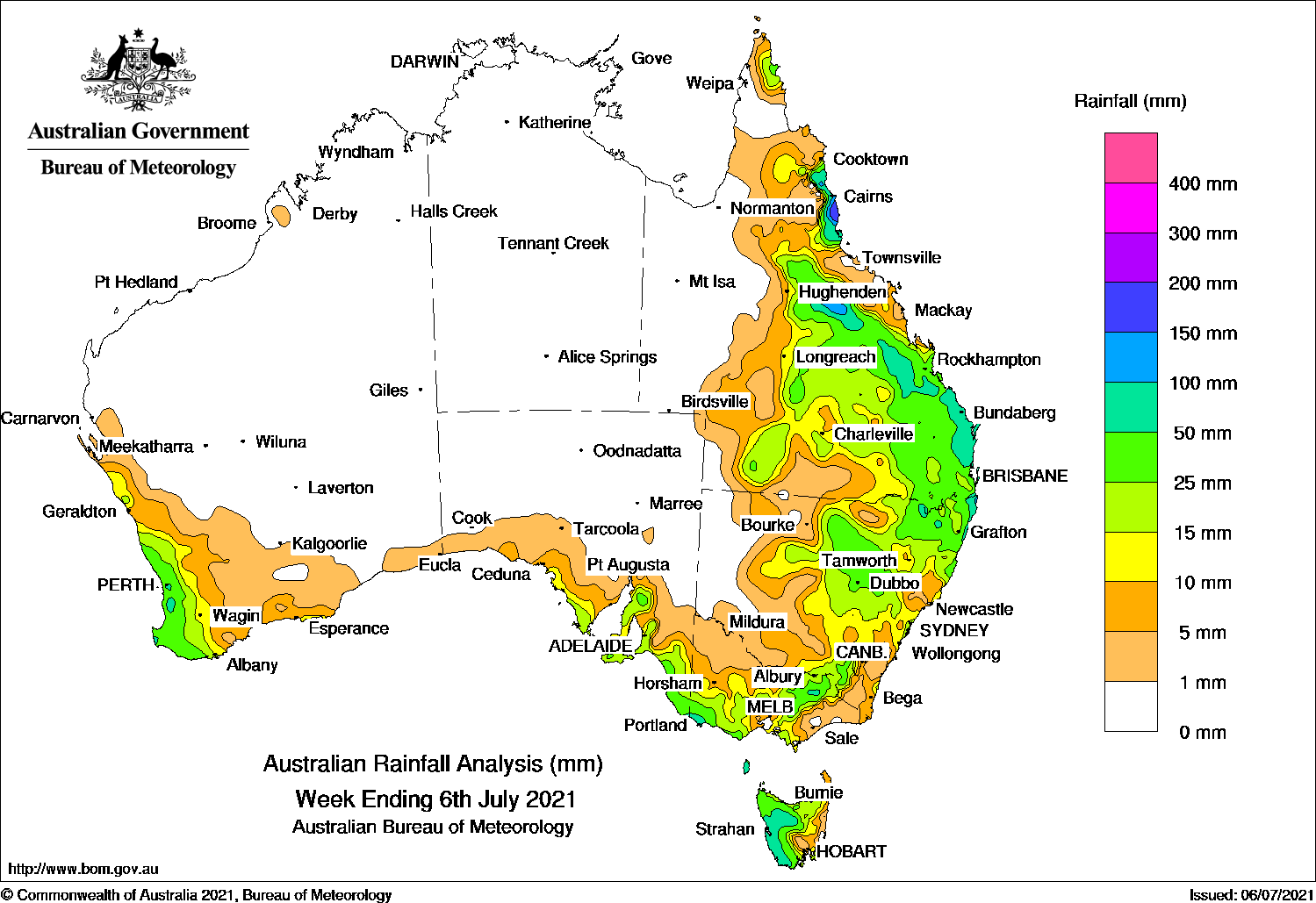
Past seven days: At the start of the week, a high pressure system in the Tasman Sea directed moist onshore flow onto the east coast of New South Wales and Queensland. A surface trough and associated cloudband extended through inland Queensland and western New South Wales, and triggered showers over southern inland Queensland, central western parts of New South Wales, and north-eastern Victoria. Onshore flow brought moderate falls to the eastern Cape York Peninsula and south-eastern Queensland, and the north-east coast of New South Wales. Heavier showers were recorded about the north tropical Queensland coast.
In the south, a cold front crossed south-west and southern Western Australia, than brushed the south coast of South Australia and Tasmania, and generated light falls along parts of the west and south coasts of Western Australia, parts of the south coast of South Australia, and western Tasmania.
During the middle part of the week, the trough and associated cloudband moved slowly across central and south-eastern districts of Queensland and north-eastern New South Wales, and interacted with onshore flow. Widespread moderate falls were recorded in large parts of Queensland, from the northern tropics, northern and central interior, Central Highlands and Coalfields, Capricornia, Wide Bay and Burnett, Darling Downs and Southeast Coast districts. Moderate rainfall was also recorded in central and north-east New South Wales.
A strong cold front quickly tracked across the southern coastline, then south-eastern Australia, with a weakening low pressure system to the west of Tasmania. Mainly light falls were recorded across southern parts of Western Australia and South Australia, and as the cold front tracked across Tasmania, the associated complex low pressure system soon followed. The systems brought moderate falls to south-eastern South Australia, south-west Victoria and the north-western half of Tasmania in the middle of the week, along with widespread light falls across parts of southern South Australia, the western two-thirds of Victoria, south-east inland New South Wales and most of Tasmania except the far south-east.
In the last part of the week, the surface trough in the east finally moved offshore, while a pair of low pressure systems moved over southern Victoria and southern Tasmania, and produced moderate falls in southern and north-eastern Victoria, and south-west Tasmania. In the west, a number of cold fronts connected to a complex low pressure system near the south-west Western Australia coast, and tracked across south-west Western Australia, bringing moderate falls to the west coast and around the Perth area at the end of the week, and widespread light falls across much of the South West Land Division.
Rainfall totals in excess of 100 mm were recorded in the north tropical coast and northern inland Queensland, and isolated parts of the Northern Rivers District in New South Wales. The highest weekly total was 265 mm at Tully Sugar Mill on the north tropical coast of Queensland.
Rainfall totals in excess of 50 mm were reported in the north tropical coast, parts of northern and central inland districts, the Wide Bay and Burnett, and far south-east coast of Queensland; pockets of the north-east and Northern Tablelands District in New South Wales; an area of south-west Victoria; western Tasmania, and an area around Perth in south-west Western Australia.
Rainfall totals between 10 mm and 50 mm were recorded along the west coast and further inland in Western Australia; parts of southern and south-east South Australia; southern, central and north-eastern Victoria; western and northern Tasmania; most of the eastern half of New South Wales, and much of eastern and southern Queensland.
Highest weekly totals
New South Wales and Australian Capital Territory
136 mm Mullumbimby (Fairview Farm)
115 mm Kingscliff (Woram Place)
107 mm Murwillumbah (Bray Park)
Victoria
79 mm Portland (Cashmore Airport)
75 mm Cape Nelson Lighthouse
60 mmPortland
Queensland
265 mm Tully Sugar Mill
227 mm Hawkins Creek
220 mm South Johnstone Exp Stn
Western Australia
80 mm Huntly, Mount William
69 mm Wanneroo
South Australia
45 mm Mount Schank (Jethia)
41 mm Robe Airfield
38 mm Robe
Tasmania
79 mmMount Read
73 mm King Island Airport, Strahan Aerodrome
Northern Territory
No rainfall recorded