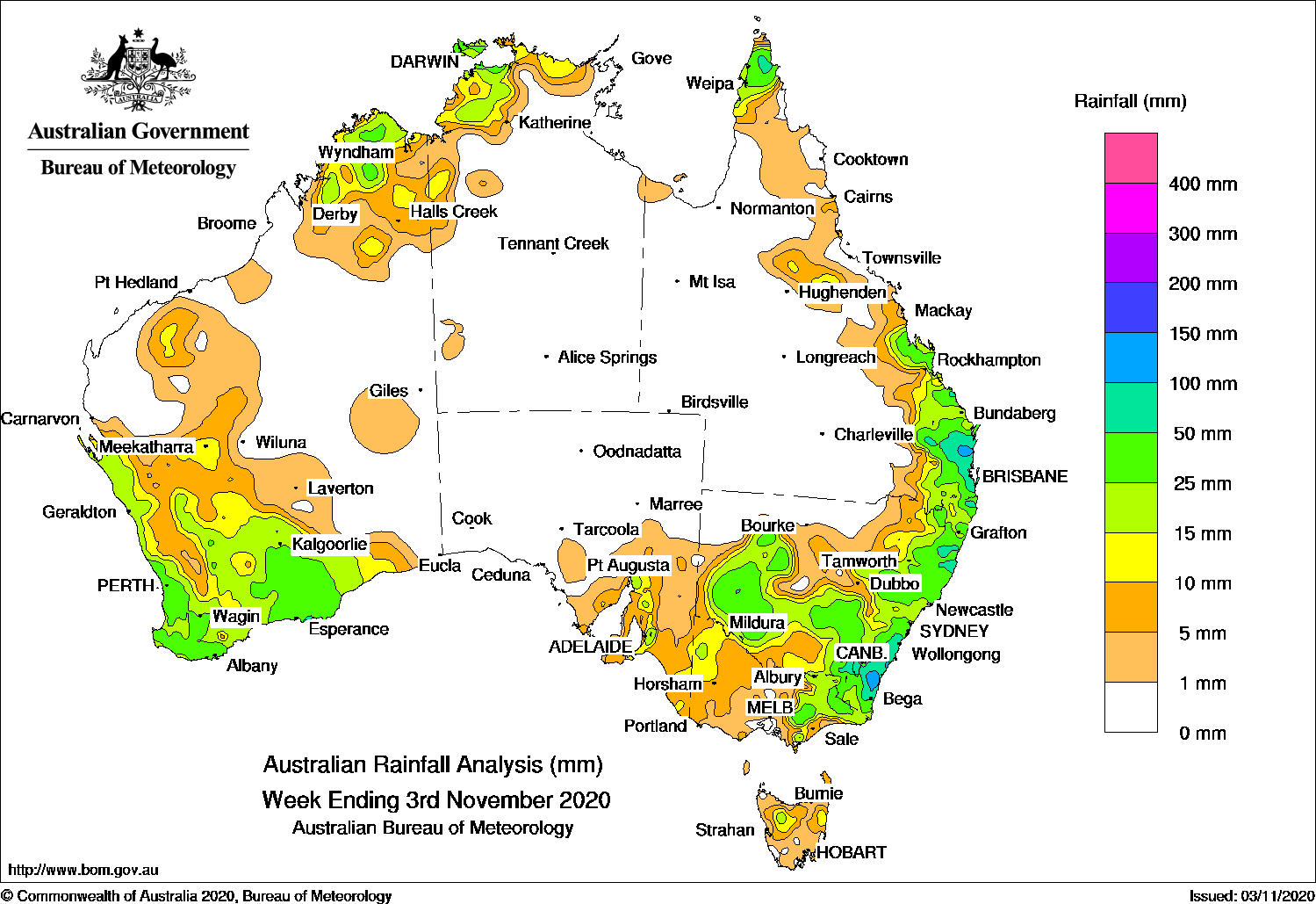
A cold front and complex low pressure system produced moderate to heavy falls in eastern New South Wales and south-east Queensland, while a cold front and low pressure system brought widespread falls to the South West Land Division in Western Australia.
Past seven days: At the start of the week, a trough extended from central Western Australia to the Top End in the northern Territory, and crossed inland eastern Queensland, towards a low in central New South Wales. Thunderstorms produced moderate falls across the Kimberley, the north-west Top End, central to south-east Queensland and parts of central to eastern New South Wales. Light to moderate falls were also reported over eastern Victoria.
In the middle of the week, a cold front and associated low pressure system tracked over south-east South Australia, north-west Victoria, then central New South Wales. Moderate falls were recorded over parts of south-east South Australia, south-west New South Wales, and north-west Victoria. The cold front moved across New South Wales and southern Queensland, connecting to the slow-moving low pressure system over central New South Wales. Further moderate falls were reported over south-west and south-east New South Wales, with light falls across northern Tasmania, eastern Victoria and remaining parts of the southern half of New South Wales.
Severe thunderstorms developed over south-east Queensland on the afternoon of the 31st, with giant hail reported across parts of western and southern Brisbane. Moderate falls were reported over south-east Queensland and far north-east New South Wales, associated with the passage of the storms.
The complex low pressure system was located just off the New South Wales south coast, and deepened in response to an active upper-level trough, generating moderate falls about the south-east coast of New South Wales, with locally heavier falls around Moruya Heads.
Showers and storms also developed along and near a surface trough located over north-western and northern Australia, with moderate falls reported in parts of the Pilbara coast and the Kimberley in Western Australia, and the Cape York Peninsula in Queensland.
In the last part of the week in the west, a cold front and pre-frontal trough generated an extensive cloud band with embedded thunderstorms as the system tracked across the west and south of Western Australia. A deep trough extended from the inland Gascoyne and the Goldfields, while a complex low moved through the South West Land Division. Widespread moderate falls were reported across the most of the South West Land Division, southern Gascoyne, Goldfields districts.
Rainfall totals in excess of 150 mm were reported in the South Coast District, including the highest weekly total of 256 mm at Moruya (Plumwood).
Rainfall totals exceeding 100 mm were recorded in south-east Queensland and along the Illawarra and south-east coasts of New South Wales.
Rainfall totals exceeding 50 mm were recorded in south-east Queensland, along parts of the north-east and south-east coasts of New South Wales, and isolated parts in the south-west Western Australia.
Rainfall totals between 10 mm and 50 mm were recorded in the Kimberley and across most of the South West Land Division in Western Australia, in the north-west and northern Top End in the Northern Territory, in the Cape York Peninsula and from central to south-east Queensland and most of New South Wales except in the north-west. Similar totals were reported in north-west and eastern Victoria, an area in northern Tasmania, and parts of south-east South Australia.
Highest weekly totals
New South Wales and Australian Capital Territory
256 mm Moruya (Plumwood)
174 mm Moruya (Burra Creek)
162 mm Ulladulla AWS
Victoria
50 mm Balook
38 mm Gelantipy
37 mm Barnawartha
Queensland
118 mm Beerburrum Forest Station
116 mm Clontarf
114 mm Imbil Post OfficeTewantin RSL Park
Western Australia
58 mm Kojonup
52 mm Mount Howick
51 mm Theda
South Australia
40 mm Ironstone Road
36 mm Lobethal (Graeber)
35 mm Woodside (Inverbrackie)Melrose
Tasmania
28 mm Loongana (Serendipity)
27 mm Gray (Dalmayne Rd)
15 mm Launceston (Ti Tree Bend), Mount Victoria (Una Plain)
Northern Territory
45 mm Gunn Point, Wagait Beach
40 mm Leaders Creek
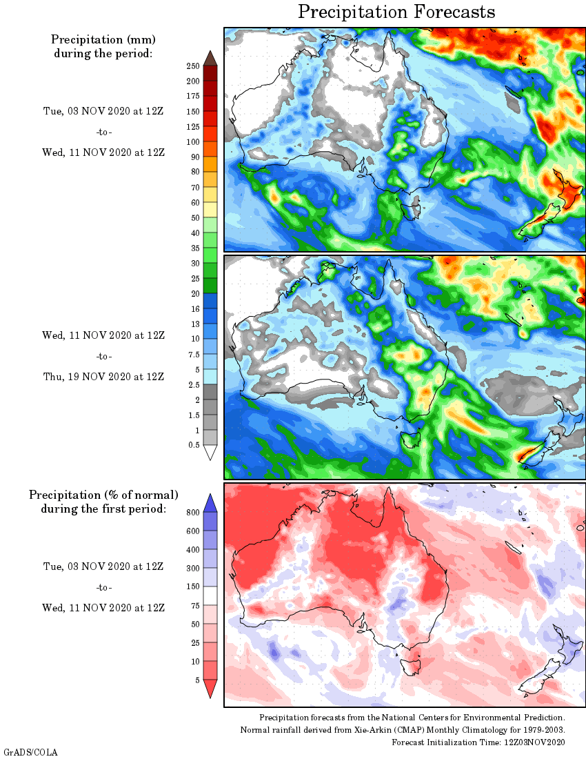
Rainfall outlook