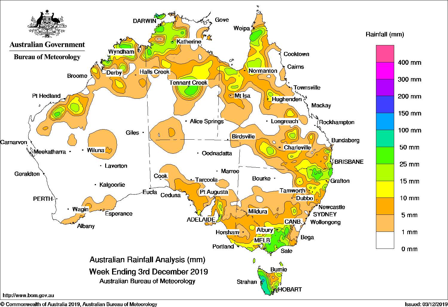
Thunderstorms developed across northern Australia, generating moderate falls, while a series of cold fronts crossed far southeast Australia.
Past seven days: At the start of the week, a broad surface trough was located across inland northwestern and northern Australia, and also extended down through inland Queensland and into northeastern New South Wales.. Light to moderate falls were recorded in parts of northern Australia, southern inland Queensland, and northeastern and central New South Wales; also in the central to eastern Victoria. A cold front tracked across the southeast, and produced moderate falls in western Tasmania.
By the middle of the week, broad areas of low pressure generated thunderstorms across northern and eastern parts of the continent, stretching from the Kimberley, through the Northern Territory, northwest to southeast Queensland, and northeastern New South Wales. Some areas reported moderate rainfall totals with isolated heavier falls associated with the passage of the thunderstorms. Further south, a pre-frontal trough and a fast moving cold front moved across southern South Australia, Victoria, southern New South Wales and Tasmania. Showers and thunderstorms produced light falls in southern South Australia, across much of Victoria and southern Tasmania; heavier falls were reported in southern central Victoria and southeast Tasmania.
In the second half of the week, a significant cold front associated with a deep low pressure system to the south of Tasmania tracked across southeast Australia, with widespread light falls recorded. Moderate falls were recorded from southern central to northeastern Victoria, elevated areas of the Snowy Mountains, and western Tasmania. A strong west to southwesterly flow swept across the southeast, embedded in a number of cold fronts passing Tasmania and southern Victoria. Thunderstorms and showers developed along a trough located across northern Australia, while another trough extending through eastern Queensland generated thunderstorms and moderate falls in southeast Queensland and northeastern New South Wales.
Rainfall totals in excess of 50 mm were recorded in a western Tasmania, including the highest weekly total of 174 mm at Mount Read. Isolated higher totals were reported from some sites, but are not reflected in the rainfall map.
Rainfall totals between 10 mm and 50 mm were recorded parts of the Pilbara and Kimberley districts in Western Australia; in areas of the northwest Top End, and central parts of the Northern Territory; areas of northern, central and southeast Queensland; northeastern and southeastern New South Wales; southern and eastern Victoria; in western and eastern Tasmania, and in parts of southeastern South Australia.
Little or no rainfall was recorded in remaining areas of Western Australia, the southern half of the Northern Territory, South Australia away from the southeast, the western half of Victoria, and along parts of the east coast and far west of Queensland.
Highest weekly totals
New South Wales and Australian Capital Territory
59 mm Mcleans Ridges (Lascott Drive)
53 mm Perisher Valley Aws
47 mm Tumut (Simpson Street), Ballina Airport Aws
Victoria
52 mm Falls Creek (Rocky Valley)
50 mm Edi UpperMount Buller
Queensland
143 mm North Head
55 mm Miranda Downs Station
53 mm Springbrook Road
Western Australia
86 mm Theda
56 mm Jubilee Downs
34 mm Old Mornington Homestead
South Australia
42 mm Ashton
40 mm Crafers West, Uraidla
Tasmania
174 mm Mount Read
120 mm Lake Margaret Dam
100 mm Queenstown (South Queenstown)
Northern Territory
128 mm Majestic Orchids
82 mm Pirlangimpi Airport
59 mm Kangaroo Flats (Defence)
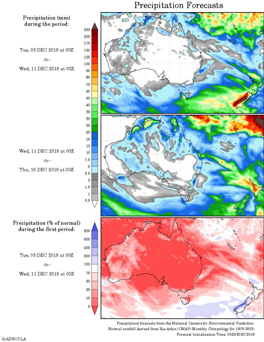
Rainfall outlook