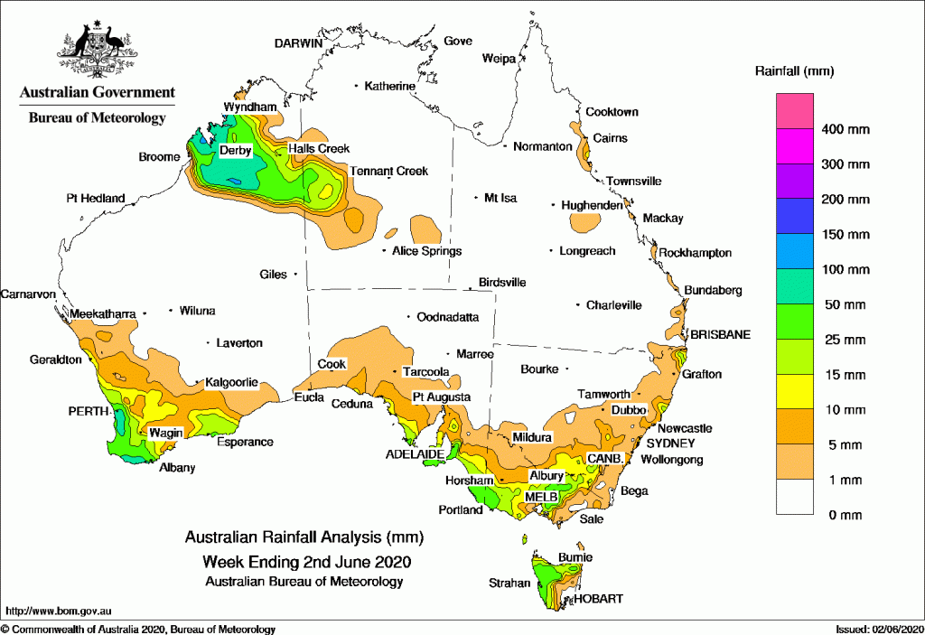
A trough brought moderate rainfall to the Kimberley in Western Australia, while cold fronts brought widespread moderate falls to the South West Land Division in Western Australia and the country’s southeast.
Past seven days: For the week to 2 June 2020, rainfall was recorded in the Kimberley and South West Land Division of Western Australia; the northwest of the Alice Springs District in the Northern Territory; southern South Australia; most of Victoria; western and northern Tasmania; and along pockets of the east coasts of New South Wales and Queensland.
In the first part of the week, a trough and an active rainband with embedded thunderstorms extended over the west Kimberley in Western Australia, and into western parts of the Northern Territory. Widespread moderate falls were recorded across the west and south Kimberley and the northwest of the Alice Springs District in the Northern Territory. Onshore flow and showers produced light falls along the east coast of New South Wales. A pair of cold fronts swept across southern Australia and brought light falls to the southwest of Western Australia, coastal South Australia, and western Tasmania.
In the second half of the week, a strong cold front tracked across southwest Western Australia, and brought moderate falls to much of the South West Land Division, and light rainfall to the Gascoyne and southern Goldfields, The cold front tracked eastwards over Victoria and brought light falls to southeastern South Australia, southwest Victoria and northwest Tasmania.
Another strong cold front followed, associated with a low pressure system in the Southern Ocean. It moved across the Bight then southeastern Australia, bringing strong and gusty winds, and moderate falls across southern South Australia, and western and northern Tasmania. The vigorous cold front continued to track across the southeast, with further moderate falls recorded in much of Victoria except the northwest and Gippsland. A complex low pressure system developed over eastern Victoria, and linked to the cold front. The system moved across eastern Victoria and New South Wales, and produced moderate falls in northeastern Victoria and southeastern New South Wales, and snow in some elevated locations along the Great Dividing Range.
Moist onshore flow produced showers along the north tropical Queensland coast at the end of the week.
Rainfall totals in excess of 100 mm were recorded in a small areas of the west Kimberley, and the South Coast in Western Australia including the highest weekly total of 98 mm at Mount William.
Rainfall totals in excess of 50 mm were recorded in the west Kimberley and far southwest of Western Australia, around the Mount Lofty Ranges and Lower Southeast districts in South Australia, and a small area of western Tasmania.
Rainfall totals between 10 mm and 50 mm were recorded across remaining parts of the west and south Kimberley and much of the South West Land Division in Western Australia; the northwest of the Alice Springs District in the Northern Territory; the Eyre and Yorke peninsulas, and southeastern South Australia; southwest, central, and northeastern Victoria; western and northern Tasmania, and pockets of the New South Wales and Queensland east coasts.
Highest weekly totals
New South Wales and Australian Capital Territory
36 mm Careys Peak (Barrington Tops)
35 mm Comboyne (Public School)
28 mm Jervis Bay NSW
Victoria
49 mm Kinglake West
43 mm StrathbogieFerny Creek
Queensland
27 mm Bingil Bay
23 mm Tully Sugar Mill
18 mm Lady Elliot Island
Western Australia
98 mm Mount William
97 mm Walpole Forestry
87 mm Kimbolton
South Australia
66 mm Bridgewater
61 mm Kangarilla (Saddlebags)
59 mm Kuitpo Forest Reserve, Uraidla
Tasmania
72 mm Mount Read
37 mm Jackeys Marsh, Mount Victoria (Una Plain)
Northern Territory
15 mm Rabbit Flat
14 mm Suplejack
6 mm Mount Denison
Rainfall outlook
![]()