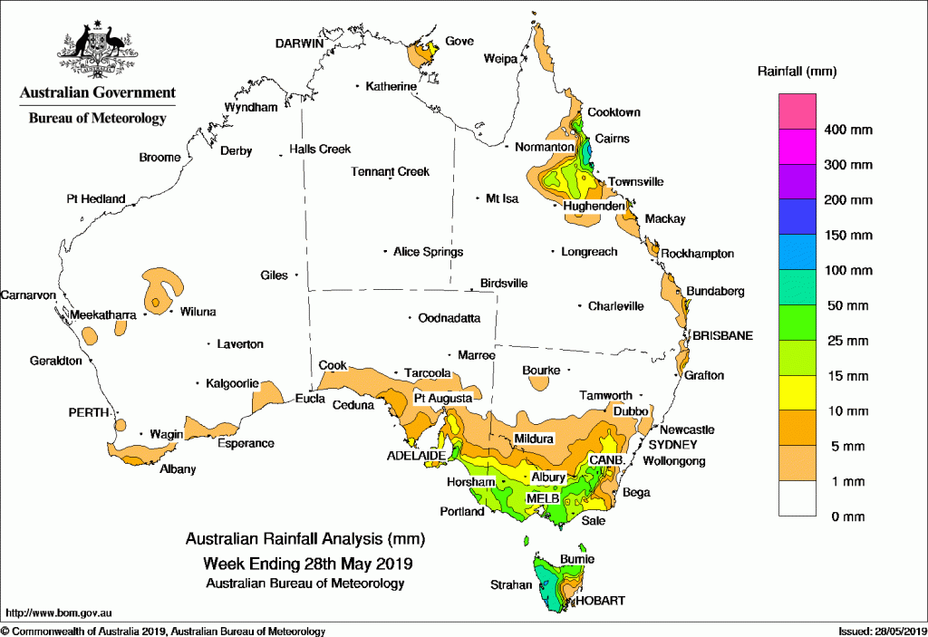
Onshore flow produced showers along Queensland’s north tropical coast, while a series of cold fronts, troughs, and lows produced moderate falls in southeast Australia.
Past seven days: Rainfall was mainly recorded in southeastern South Australia, Victoria, Tasmania, inland southeastern New South Wales, and the north tropical coast and adjacent inland districts of Queensland.
In the first part of the week, a moist onshore flow produced showers with moderate falls about the north tropical Queensland coast, and light falls about parts of Queensland’s central and southeast coasts. Onshore winds and showers continued along parts of the exposed east coast of Queensland throughout the week, with more frequent showers and moderate falls about the north tropical coast and adjacent inland districts.
 From mid-week, a series of low pressure systems, cold fronts, and troughs moved across the Southern Ocean, and produced an extensive cloudband with isolated thunderstorms over the southeast of the country. Moderate falls were reported in northern and western Tasmania, and in the northeast of Victoria, with light falls across large areas of both States.
Another strong cold front followed, tracking across southern South Australia, Victoria and Tasmania. Further moderate falls were recorded in southern central Victoria and in the Victorian Alps, the Snowy Mountains in New South Wales, and in western and northern Tasmania.
At the end of the week, a vigorous westerly airstream became established over the southeast of Australia, as the next strong cold front moved over the Tasman Sea. Extensive thunderstorms on the leading edge of the front produced moderate falls across southeastern South Australia; southwest, southern central, and northeastern Victoria; the Snowy Mountains in New South Wales; and northern and western Tasmania.
Rainfall totals in excess of 100 mm were recorded in the north tropical coast of Queensland and in parts of western Tasmania. The highest weekly total was 151 mm at Bingil Bay in northern Queensland.
Rainfall totals in excess of 50 mm were recorded in the north tropical Queensland coast and most of western Tasmania, along with some isolated parts of West Gippsland in Victoria, the Snowy Mountains in New South Wales, and the Mount Lofty Ranges in southeast South Australia.
Rainfall totals between 10 mm and 50 mm were recorded in remaining areas of the north tropical Queensland coast and adjacent inland districts; the Snowy Mountains and Tablelands in New South Wales; most of Victoria except in the far northwest and some border regions in the east; southeastern South Australia; and northern and western Tasmania.
Little or no rainfall was recorded in Western Australia, the Northern Territory away from the northeastern tip of the Top End, South Australia away from the southeast and the coast, Queensland away from the east coast and northern tropics, most of New South Wales except in the inland southeast and Snowy Mountains, and parts of southeastern Tasmania.
Highest weekly totals
New South Wales and Australian Capital Territory
72 mm Perisher Valley AWS
51 mm Thredbo Village
37 mm Cabramurra AWS
Victoria
64 mm Wilsons Promontory Lighthouse
58 mm Grampians (Mount William)
53 mm Corner Inlet (Yanakie)
Queensland
151 mm Bingil Bay
150 mm Tully Sugar Mill
128 mm Innisfail
Western Australia
8 mm Margaret RiverNorth Walpole
7 mm Doolgunna
South Australia
74 mm Ashton
60 mm Mount Lofty
56 mm Crafers West
Tasmania
150 mm Mount Read
119 mm Queenstown (South Queenstown), Lake Margaret Power Station
Northern Territory
22 mm Alcan Minesite
12 mm Gove Airport
6 mm Ngayawili


