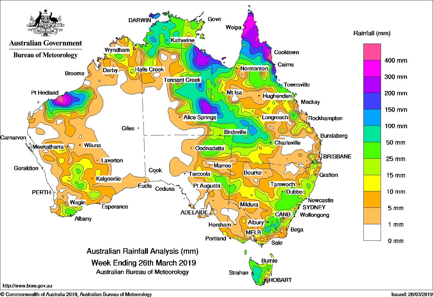
Severe tropical cyclone Trevor produced heavy falls in the Cape York Peninsula and Gulf Country; also the north tropical Queensland coast. Severe tropical cyclone Veronica approached the northwest coast near Port Hedland, bringing heavy falls to the Pilbara coast.
Past seven days: At the start of the week, surface troughs extended through western, northern, and eastern Australia, generating isolated showers and thunderstorms through inland Western Australia and along the east coast of New South Wales. The monsoon trough was located across far northern Australia.
In the first part of the week, severe tropical cyclone Trevor was situated on the monsoon trough, near Lockhart River on the eastern side of the Cape York Peninsula. Trevor made landfall just south of Lockhart River, and brought widespread heavy falls to the Cape York Peninsula and north tropical coast of Queensland; moderate falls were reported through parts of northern and central Queensland. Trevor tracked across the far north of the Cape York Peninsula, and generated heavy falls.
 Thunderstorms developed over the east coast of New South Wales and southeast Queensland due to an active surface trough in the region, and produced moderate falls.
Meanwhile, tropical cyclone Veronica formed along the monsoon trough, off the northwest of Western Australia. The system rapidly intensified into a severe tropical cyclone, and approached Port Hedland on the Pilbara coast. Thunderstorms and heavy falls extended over a large area to the north and south of the system, with moderate to heavy falls recorded across much of the Pilbara coast and adjacent inland districts. A trough connected Veronica in the west and Trevor in the Gulf of Carpentaria, and produced an area of instability and isolated showers and storms over the Top End in the Northern Territory.
Mid mid-week, Trevor had re-intensified to a category 4 strength system over the Gulf of Carpentaria. Severe tropical cyclone Trevor tracked towards the Carpentaria coast of the Northern Territory, and made landfall south of Port McArthur, generating heavy falls. After Trevor made landfall, the system weakened to an ex-tropical cyclone, and continued to track south through the east of the Northern Territory, producing widespread moderate falls in eastern parts of the Northern Territory and western Queensland.
Veronica was lingering off the northwest coast in the last part of the week without making landfall, and continued to generate widespread moderate to locally heavy falls over the Pilbara.
In the south, showers associated with surface troughs brought light falls along the east coast and northern and eastern Tasmania at the start of the week, while a surface trough also brought light to moderate falls in the southwest of Western Australia. As the week progressed, a thick cloudband associated with the passage of a series of strong cold fronts extended across much of southeast Australia. Rain and thunderstorms generated moderate falls across Tasmania’s Central Plateau and northeast, and northeast Victoria and eastern New South Wales in the middle of the week. In the last part of the week moderate falls were recorded in the Northeast Pastoral District of South Australia, through central New South Wales, and the inland slopes in northeast Victoria and southeastern New South Wales, and across western and northern Tasmania. Widespread light falls were reported over large parts of Victoria, Tasmania, and southern New South Wales.
Totals in excess of 300 mm were recorded on the tip of the Cape York Peninsula, between Cooktown and Cairns in the north tropical coast of Queensland, and on the Pilbara coast between Port Hedland and Karratha. The highest weekly total was 634 mm at Indee, around 60 km south of Port Hedland in northwest Western Australia. Several other locations in the coastal Pilbara, far north of Cape York Peninsula, and Queensland’s north tropical coast also approached or exceeded 400 mm for the week. The second highest weekly total was 583 mm at Mossman South Alchera Drive, near port Douglas in Queensland.
Rainfall totals in excess of 200 mm were recorded in the Pilbara coast surrounding Port Hedland, parts of the southern Gulf Coast in the Northern Territory, and areas of far northern Queensland.
Rainfall totals in excess of 50 mm were recorded across much of the Pilbara; western Tasmania; parts of northeastern Victoria and elevated areas in southeast New South Wales; the western to central Top End and eastern parts of the Northern Territory; most of the Gulf Country; and northern and southwestern Queensland.
Rainfall totals between 10 mm and 50 mm were recorded in the Kimberley District in Western Australia and large parts of the western half of that State; parts in the north and east of the Northern Territory; the Northeast Pastoral and Flinders districts in South Australia; and in much of southern coastal, central, and northeastern Victoria. Similar totals were also recorded across most of Tasmania; across eastern New South Wales, and in a band through the middle of the State to the western border; and in much of Queensland except the inland southeast and parts of the Central Highlands and inland northwest.
Little or no rainfall was recorded along much of the west coast of Western Australia or in the Interior and Eucla districts, the western half of South Australia, the southwest of the Northern Territory, parts of inland southeastern Queensland, and pockets of northeast New South Wales and northwest Victoria.
Highest weekly totals
New South Wales and Australian Capital Territory
121 mm Perisher Valley AWS
112 mm Thredbo AWS
93 mm Thredbo Village
Victoria
146 mm Mount Hotham
130 mm Falls Creek (Rocky Valley)
79 mm Howitt Plains (High Ridge)
Queensland
593 mm Mossman South Alchera Drive
498 mm Lockhart River Airport
489 mm Whyanbeel Valley
Western Australia
634 mm Indee
558 mm Mallina
391 mm Carlindie
South Australia
42 mm Kalamurina
36 mm Wilpena Pound
30 mm Curnomona (Curnamona)
Tasmania
87 mm Lake Margaret Power Station, Mount Read
80 mm Upper Blessington
Northern Territory
249 mm Merlin Mine
237 mm Dum In Mirrie Airstrip
200 mm Pirlangimpi Airport
Source: BOM
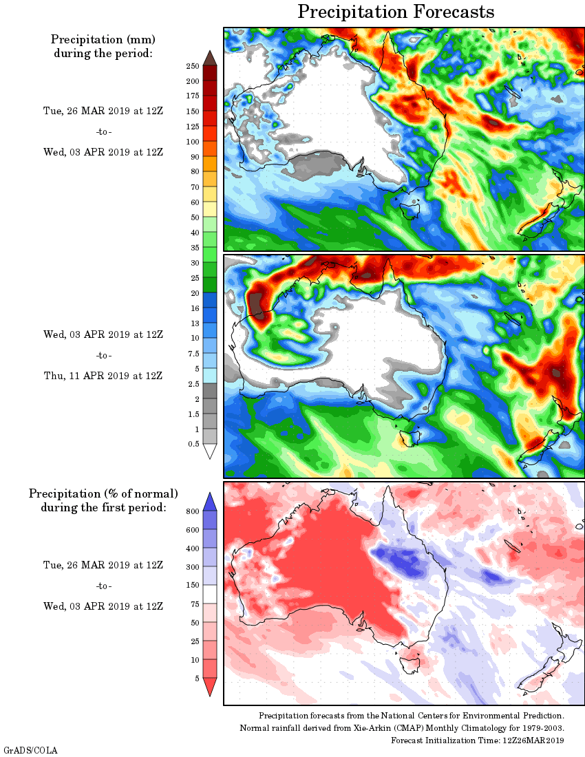
Rainfall outlook: