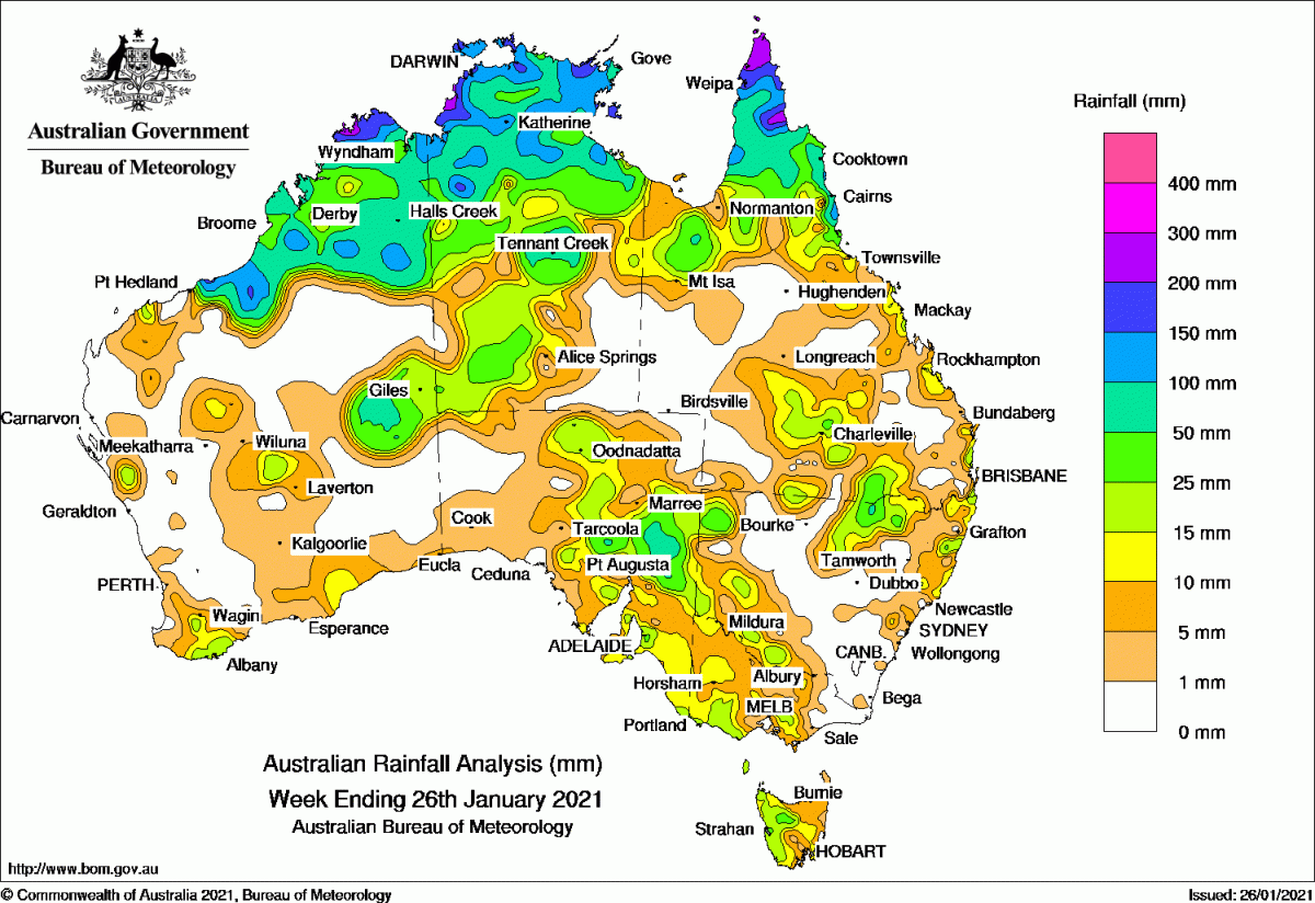
Rainfall was recorded in all states and territories, with moderate to heavy falls across the northern tropics.
Past seven days: At the start of the week, a tropical low was embedded in a monsoon trough, located off the Kimberley coast in Western Australia, while another trough extended from the Gulf of Carpentaria to the northern Coral Sea. Widespread thunderstorms and showers developed across the northern tropics, with moderate falls across the Kimberley in Western Australia, the Top End in the Northern Territory, the Gulf Country and the Cape York Peninsula. Surface troughs also produced isolated thunderstorms and showers in the Gascoyne and south-west coast of Western Australia and along the east coast between south-east Queensland to the central coast of New South Wales.
The tropical low moved south-west along north-west Western Australian waters before turning south and crossing the far west Kimberley coast on the 22nd. The remnants of the low continued to track across the state’s interior and south-east, and produced moderate falls in its passage. Multiple troughs crossed through central Australia and South Australia, to produce showers and thunderstorms, with moderate falls recorded in the interior and eastern Western Australia, southern parts of the Northern Territory, and northern South Australia.
In the last part of the week, a number of weak cold fronts tracked across the Great Australian Bight and far south-east Australia, with a pre-frontal trough spanned across South Australia. The systems produced moderate falls across eastern South Australia, far western New South Wales, western Victoria and Tasmania.
Thunderstorms and showers continued to produce moderate falls across the northern tropics for the rest of the week. A tropical low intensified in the Gulf of Carpentaria at the end of the week and generated moderate falls across the western Cape York Peninsula.
Rainfall totals in excess of 200 mm were recorded in parts of the Kimberley in Western Australia, the north-west Top End in the Northern Territory and the northern Cape York Peninsula. The highest weekly total was 389 mm at Lockhart River Airport in northern Queensland.
Rainfall totals in excess of 100 mm were recorded in parts of the Kimberley in Western Australia, the Top End in the Northern Territory, areas of the Cape York Peninsula, and the north tropical coast of Queensland.
Rainfall totals between 10 mm and 50 mm were recorded in the Kimberley, the eastern interior and scattered parts of southern Western Australia; most of the Top End except the south-east; most of eastern South Australia; and across northern, eastern and southern inland Queensland. Similar totals were recorded western, northern inland and north-eastern New South Wales, most of the western half of Victoria, and western Tasmania.
Highest weekly totals
New South Wales and Australian Capital Territory
63 mm Mungindi Post Office
51 mm Point Lookout
46 mm Pallamallawa Post Office
Victoria
34 mm Toorourrong Reservoir
31 mm Kinglake West (Wallaby Creek)
30 mm Coldstream, Upper Plenty
Queensland
389 mm Lockhart River Airport
241 mm Horn Island
212 mm Scherger RAAF
Western Australia
259 mm Truscott
233 mm Troughton Island
195 mm Theda
South Australia
108 mm Yunta (Panaramitee)
68 mm Blinman
59 mm Koonamore
Tasmania
28 mm Strahan (Andrew Street)
27 mm Jackeys Marsh, Mount Read
Northern Territory
254 mm Channel Point
218 mm Dum In Mirrie Airstrip
206 mm Upper Waterhouse River
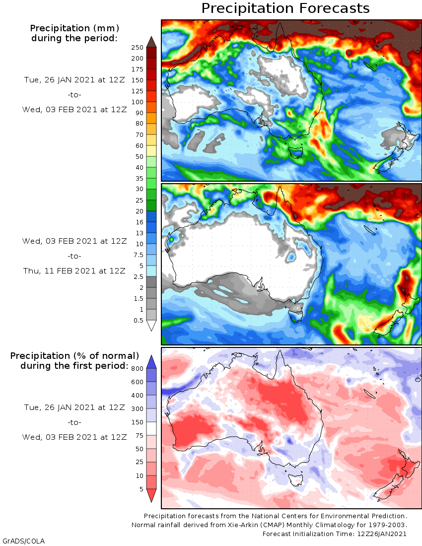
Rainfall outlook