Cold fronts brought moderate falls to southwest Western Australia, while a complex low pressure system and cold front produced moderate falls in the southeast, heavy falls to southern Tasmania.
Past seven days: A strong and gust westerly flow over Tasmania associated with the passage of a cold front, brought moderate falls to the State’s southwest at the start of the week. A high pressure system moved across southeastern Australia into the Tasman Sea, and extended a ridge along the east coast of Australia, generating moist onshore flow. Moderate falls were reported from the central to northeast coasts of New South Wales, the north tropical and southeast coasts of Queensland. In the west, a strong cold front moved across the western parts of Western Australia, and a weak low pressure system soon tracked across the southwest coast. A broad cloudband generated moderate falls across much of the South West Land Division and the southwest Gascoyne coast, while light falls were recorded in the remaining parts of the Gascoyne, southern Goldfields and along parts of the State’s south coast.
The cold front was located over South Australia by the middle of the week and linked to a complex low pressure system to the south of the Great Australian Bight. Moderate falls were recorded along parts of the exposed south coast of South Australia and in northeastern Victoria. As the cold front and associated complex low moved slowly across the country’s southeast, a rainband and embedded thunderstorms brought moderate falls to parts of southeast South Australia, the Victorian Alps, the Snowy Mountains, and from the Southern to Northern Tablelands in New South Wales.
The complex low was located in the Bass Strait and the Tasman Sea by the end of the week, with moderate to locally heavy falls recorded in southern Tasmania, including 175.4 mm at kunanyi / Mount Wellington to 9am on 23 June, a new June daily rainfall record for that site. Moderate falls were reported in southern Victoria while widespread light falls were reported over southern South Australia, Tasmania, most of Victoria, southern and eastern New South Wales, and southeast Queensland.
In the west, a cold front and pre-frontal trough tracked across the west coast, generating moderate falls along the Gascoyne coast and southwest of Western Australia at the end of the week.
Moist onshore flow brought showers along parts of the east coast of Queensland. Heavier showers were reported along the north tropical Queensland coast during the week. Isolated light showers were also recorded in the northeast of Arnhem Land in the Northern Territory at the latter part of the week.
Rainfall totals in excess of 100 mm were recorded in southern Tasmania, including highest weekly total of 224 mm at kunanyi / Mount Wellington in Hobart
Rainfall totals in excess of 50 mm were recorded in southwest Western Australia, the southern half of Tasmania, northeastern Victoria, in the Snowy Mountains in New South Wales, and the north tropical coast of Queensland.
Rainfall totals between 10 mm and 50 mm were recorded for much of the South West Land Division, and southwest Gascoyne in Western Australia, parts of southern South Australia, and in western, central and northeastern Victoria. Similar totals were recorded inmost of Tasmania, much of central to eastern New South Wales, and in the north tropical and southeast coasts of Queensland.
Falls of less than 10 mm were recorded in the Gascoyne, and much of southern Western Australia; southern South Australia; remaining parts of Victoria; much of inland New South Wales away from the northwest; and in Queensland’s southeastern quarter, central coast, and northern tropics.
Highest weekly totals
New South Wales and Australian Capital Territory
76 mm Thredbo Village
70 mm Perisher Valley AWS
65 mm Khancoban AWS
Victoria
91 mm Hunters Hill
62 mm Mount Hotham
55 mm Falls Creek
Queensland
80 mm Innisfail
78 mm Innisfail Aerodrome
65 mm Tully Sugar Mill
Western Australia
90 mm Mount William
86 mm Worsley Downs
82 mm Ferguson Valley
South Australia
83 mm Parawa
76 mm Ashton
75 mm Belair (State Flora Nursery)
Tasmania
224 mmkunanyi / Mount Wellington
153 mmLongley (River Bend Road)
147 mmCrabtree (Stoney Creek Farm)
Northern Territory
7 mm Ngayawili
4 mm Wagait Beach
1 mm Darwin Airport
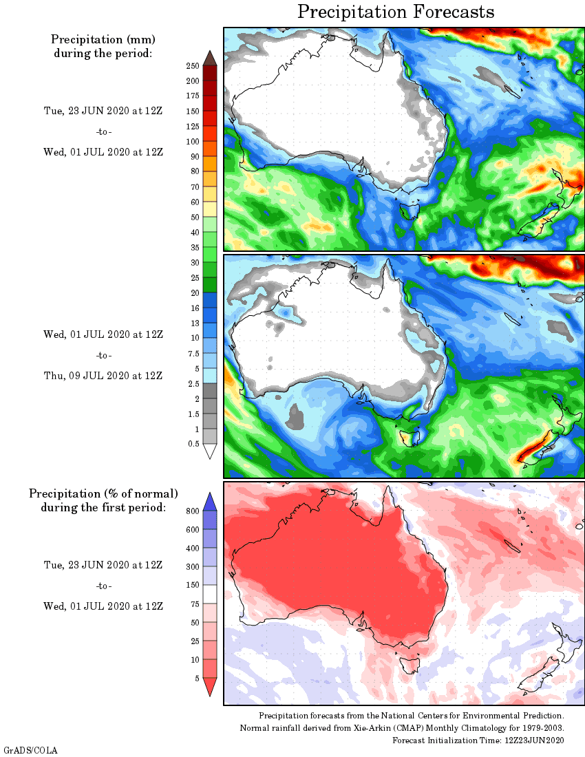
Rainfall outlook