Cold fronts and westerly flow brought moderate falls to southwest and southeast Australia, while a trough and cold front brought widespread moderate falls into eastern and southern Queensland.
Past seven days: At the start of the week, a surface trough lingered near the New South Wales coast, and brought showers and moderate falls along the northeast to central coasts of that State, and light falls to the southeast coast of Queensland. Onshore flow also brought moderate falls to the north tropical coast of Queensland.
In the south, a weak cold front tracked across Tasmania and produced moderate falls in southwest Tasmania, then light falls in the State’s north.
In the west, a trough tracked across western parts of Western Australia, and an associated low pressure system moved through southern parts of the State, bringing moderate falls along the west and southwest coast. A cold front followed, and moved across southern Western Australia, generating further moderate falls over the southwest coast, and widespread light falls along the Pilbara and Gascoyne coasts, much of the South West Land Division and parts of the Goldfields. As the cold front and pre-frontal trough moved eastwards, large areas of southern and central Western Australia and southwest South Australia reported light falls, with moderate falls along parts of the exposed south coasts.
By the middle of the week, the cold front was located near the western border of Victoria and New South wales, and generated a large cloudband across southern Queensland, New South Wales, Victoria and Tasmania. The cold front moved across southeast Australia, with an associated pre-frontal trough extending through inland Queensland to the Gulf Country. The system generated widespread moderate falls across central to southern Queensland, central to eastern New South Wales, central to northeast Victoria, parts of southeastern South Australia and northern Tasmania. As the trough pushed eastwards, showers and widespread moderate falls were recorded from the north tropical to southeast coast of Queensland, and adjacent inland districts.
A second front crossed Victoria and Tasmania, with moderate falls in far southeast South Australia, southwest and northeast Victoria and western Tasmania. A strong and gusty westerly flow over southeast Australia produced moderate falls in northeast Victoria, and western and northern Tasmania at the end of the week.
Isolated totals exceeding 100 mm were recorded in parts of the northeast coast of New South Wales and an area of western Tasmania, including the highest weekly total of 156 mm at Mount Read.
Rainfall totals in excess of 50 mm were recorded in western Tasmania, the northeast to central coast of New South Wales, in pockets of east coast of Queensland, and a small area in the South West District in Western Australia.
Rainfall totals between 10 mm and 50 mm were recorded along the west coast, parts of the south coast and pockets in the eastern South West Land Division and Goldfields in Western Australia, and southern and far southeast South Australia. Similar totals were recorded in southwest, central and northeastern Victoria; most of Tasmania; much of central to eastern New South Wales; and in the northern tropics, central, southern and southeastern Queensland.
Falls of less than 10 mm were recorded across much of western and southern Western Australia, the southern half of South Australia, remaining parts of Victoria, parts of western New South Wales, southern inland Queensland, and isolated parts of Arnhem Land and the tip of the Cape York Peninsula.
Highest weekly totals
New South Wales and Australian Capital Territory
120 mm Bellwood (Nambucca Heads)
119 mm Port Macquarie Airport AWS
104 mm Old Bar (Ondarro Crest)
Victoria
101 mm Mount Buller
94 mm Grampians (Mount William)
77 mm Jamieson Licola Rd
Queensland
85 mm Springbrook Road
74 mm Taroom Post Office
67 mm Mount Mcconnell
Western Australia
60 mm Ferguson Valley
57 mm Ferguson Valley Alert
55 mm BurekupLudlow
South Australia
69 mm Ashton
67 mm Myponga
66 mm Uraidla
Tasmania
156 mm Mount Read
120 mm Lake Margaret Dam
102 mm Lake Margaret Power Station
Northern Territory
3 mm Gove Airport
2 mm Milingimbi Airport
1.6 mm Ngayawili
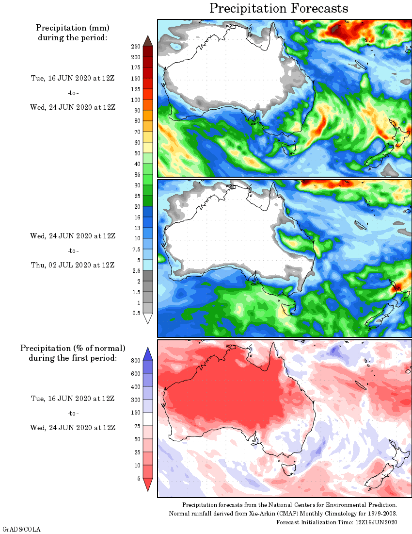
Rainfall outlook