SEVERE tropical cyclone Seroja and its remnants produced heavy daily rainfall in the Central West and south-west of Western Australia, while cold fronts produced moderate rainfall in far south-east of Australia, with snow across the southern Alps.
Past seven days: At the start of the week, a trough and associated low pressure system off the south-east coast in Queensland moved further offshore. Onshore winds led to moderate rainfall in Cape York Peninsula, the north tropical coast, inland central and south-east Queensland, and along the central and north coast of New South Wales.
Tropical cyclone Seroja was located north of the west Pilbara coast early in the week, with a deepening tropical low not far away to its west. A cloudband extended from the system south-east to the Great Australian Bight, generating light to moderate falls along the southern coastlines in Western Australia.
From the mid-week onward, Seroja interacted with the tropical low (this low later became the shorted-lived tropical cyclone Odette) and intensified to severe (category 3 strength) before tracking south-east towards the west coast of Western Australia. Severe tropical cyclone Seroja crossed the coast just south of Kalbarri in the Central west Coast District on the 11th, then tracked rapidly across eastern parts of the South West Land Division before moving into the Bight as a low pressure system. Moderate rainfall was recorded in the west Pilbara prior to the landfall. Widespread moderate daily rainfall was recorded in the west and south Gascoyne District, most of the South West Land Division, and southern Goldfields District on the 12th. Heavier daily falls between 50 and 100 mm were observed near Seroja and on its south-western side.
In the country’s south-east, a number of cold fronts produced a number of days of moderate rainfall in western Tasmania. Light falls were reported in eastern Tasmania, and light to moderate falls in southern, central, and eastern Victoria. In the south-east this was likely the most significant cold outbreak in the first half of April since 1995. Snow fell across the southern Alps, with light flurries in some lower elevations including the Dandenong Ranges.
In the tropics, rainfall was mostly confined to the north-west Top End in the northern Territory and Cape York Peninsula in Queensland.
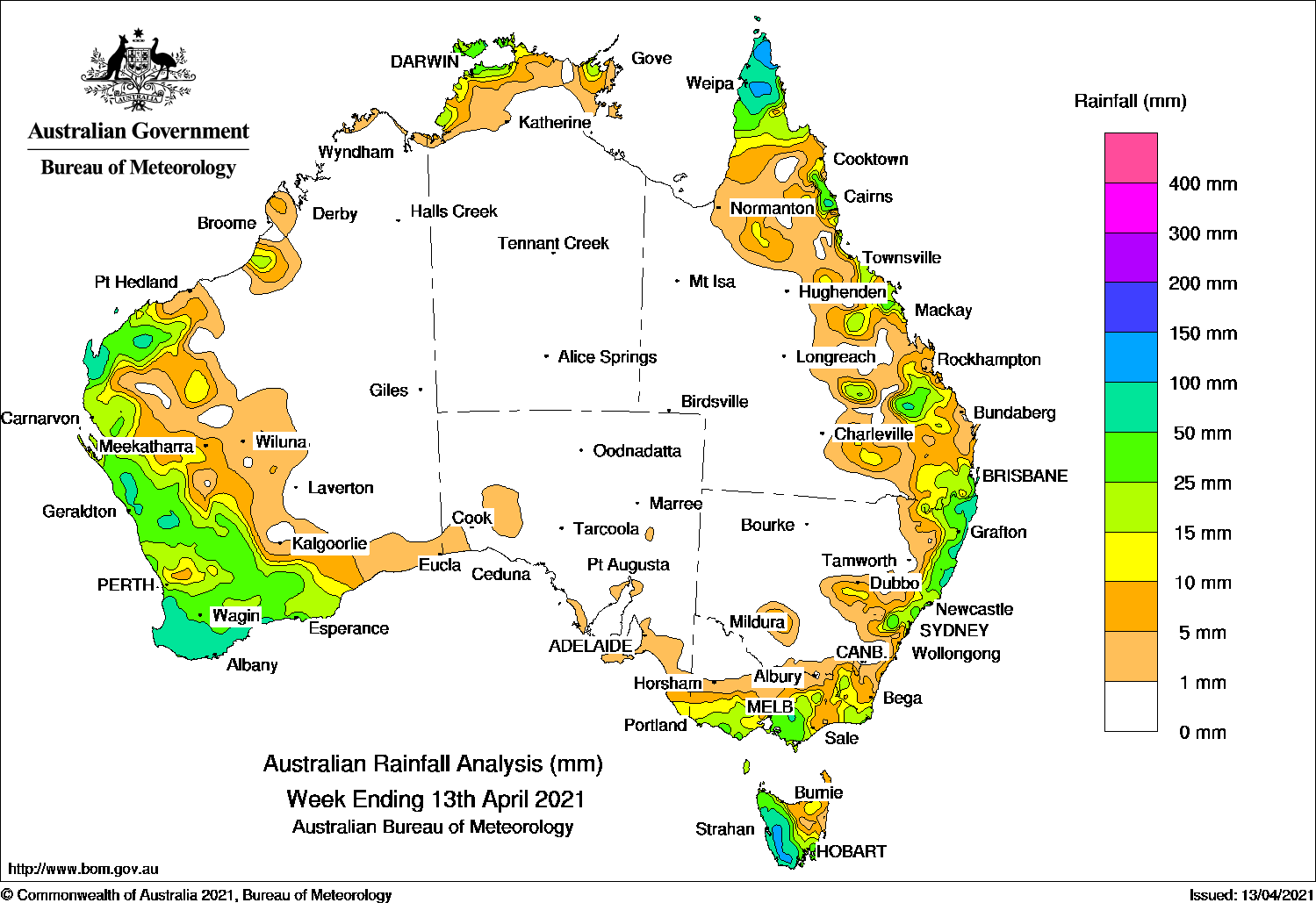
Rainfall totals between 50 mm and 100 mm were recorded in the west Pilbara, the Central West, South West and Great Southern districts in Western Australia, spots in the north-western Northern Territory, the Cape York Peninsula, the north tropical coast and south-east coast of Queensland, the central and northern coasts of New South Wales, the central and alpine regions of Victoria, and western Tasmania. The highest weekly rainfall total was 114.2 mm at Worsley Downs in the South West District in Western Australia.
Rainfall totals between 10 mm and 50 mm were recorded in the western half of Western Australia, along the coast in the Northern Territory, in the far north and parts of eastern Queensland, along the central and northern coasts of New South Wales, in southern, central and north-eastern Victoria, and the west and south of Tasmania. The far south-eastern corner of South Australia recorded a little more than 10 mm for the week.
Highest weekly totals
New South Wales and Australian Capital Territory
112 mm Yarras (Mount Seaview)
111 mm Tweed Heads Golf Club
92 mm Kingscliff (Woram Place)
Victoria
96 mmFerny Creek
69 mmMonbulk (Spring Road)
60 mmSpringvale Necropolis
Queensland
103 mm Merluna
102 mm Bramwell
97 mm Weipa Aero
Western Australia
114 mm Worsley Downs
102 mm Barrow Island Airport
100 mm White Gums
South Australia
12 mm Mount Gambier Aero
11 mm Lake George (Maharishi Vedic C
8 mm RobeBelair (State Flora Nursery)Parawa (Second Valley Forest A
Tasmania
111 mm Lake Margaret Power Station
108 mm Lake Margaret Dam
99 mm Mount Read
Northern Territory
78 mm Mount Bundey North (Defence)
63 mm Howard Springs Nature Park
47 mm Black Point
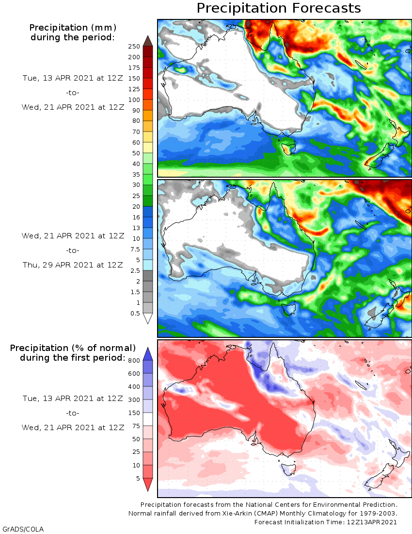
Rainfall outlook