Strong cold fronts and intense lows produced moderate falls and snow to low levels in parts of the southeast, as cold fronts brought light falls to parts of the southern coasts of Western Australia and South Australia, prior to the cold outbreak in the southeast.
Past seven days: At the start of the week, a cold front moved across southern parts of Western Australia and South Australia. Another cold front to the east of Tasmania and associated low pressure system to the south linked to a surface trough over Victoria and eastern South Australia. Embedded thunderstorms and moderate falls extended from the southern coastal parts of Western Australia through to the southern parts of South Australia and across Victoria. A moist onshore flow brought showers to parts of Queensland’s east coast. The cold front moved across the far southeast while a cold front developed and moved through the eastern New South Wales.
From the first part of the week, a large complex low pressure system with triple centres developed in southeast Australia: one centre was located to the east of Tasmania, while the second was situated over far southeastern South Australia, and the third approaching from the deep south of the Bight. The complex low pressure systems, and associated strong cold fronts and extensive low and middle level cloud moved across the southeast and produced moderate falls in southeastern South Australia, southern Victoria, and western and southern Tasmania in the middle of the week. Snow was recorded in parts of the Snowy and Blue Mountains in New South Wales and down to elevations of around 300 m; also in the Victorian Alps and down to elevations of around 500 m. Widespread light falls were recorded across most of remaining parts of Victoria except East Gippsland, and much of Tasmania away from the east.
In the last part of the week, another pair of cold fronts tracked from the southwest to northeast across Tasmania, Victoria and New South Wales, and produced a cold southerly burst that extended as far north as Queensland. Widespread light falls were recorded across most of Tasmania, most of Victoria except in the northwest, and through the southern and central inland parts of New South Wales. A trough brought light rainfall near the west coast of Western Australia.
Rainfall totals in excess of 100 mm were recorded in the Snowy Mountains in New South Wales, parts of the Victorian Alps and southern central Victoria, and a small area of western Tasmania. The highest weekly total was 150 mm at Mount Baw Baw in Victoria.
Rainfall totals in excess of 50 mm were recorded in southwest Tasmania, southern central to northeastern Victoria and extending into the Snowy Mountains in New South Wales, and about the Mount Lofty Ranges and Yorke Peninsula in South Australia.
Rainfall totals between 10 mm and 50 mm were recorded along the south coasts of Western Australia and South Australia; most of Victoria except the far northwest; western, southern and northeastern Tasmania; the Snowy Mountains, Southern and Central Tablelands districts in New South Wales, and isolated pockets of Queensland’s east coast.
Little or no rainfall was recorded in Western Australia and South Australia away from the south coasts; the Northern Territory; northern, central and east coast New South Wales, and most of Queensland.
Weekly rainfall totals map
Highest weekly totals
New South Wales and Australian Capital Territory
109 mm Perisher Valley Aws
75 mm Argalong (Sandy Creek)
58 mm Fairlight Station
Victoria
150 mm Mount Baw Baw
146 mm Falls Creek (Rocky Valley)
109 mm Jindivick
Queensland
22 mm Innisfail
20 mm Sandy Cape Lighthouse
16 mm Babinda Post Office
Western Australia
33 mm Dalyup Park
31 mm Albany
30 mmKing River
South Australia
85 mm Longwood
83 mm LenswoodUraidla
Tasmania
106 mm Mount Read
100 mm Woodbridge
95 mm Scotts Peak Dam
Northern Territory
0.4 mm Centre Island
0.2 mm Borroloola Airport, Ngukurr Airport
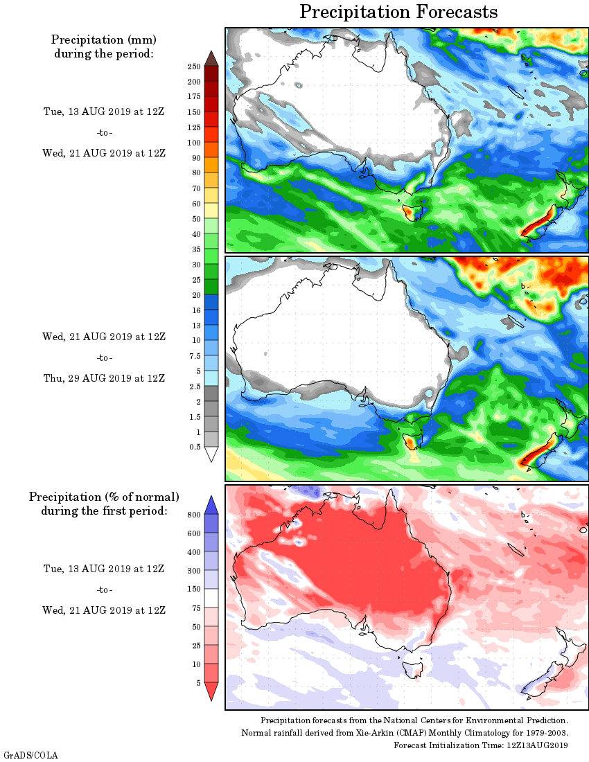
Rainfall outlook: