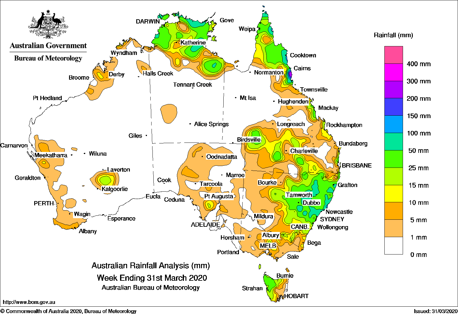
Showers and thunderstorms developed over eastern New South Wales, generating moderate falls, while onshore flow produced showers and moderate falls in the northern tropics.
Past seven days: At the start of the week, several surface troughs were present: extending along the west coast, from Central Australia to southern South Australia, and from the Gulf Country to eastern Victoria. An upper level disturbance interacted with the surface troughs and produced showers along the west coast of Western Australia, and much of eastern South Australia.
The interaction between an upper-level disturbance and the eastern surface trough generated an extensive cloudband over eastern New South Wales and inland southeast Queensland. Widespread light to moderate rainfall totals were recorded over much of the northeastern quarter of New South Wales and light falls were reported over southern inland Queensland. Another trough lingered off the north coast of New South Wales, and generated locally heavier falls.
 Onshore flow produced showers along much of the east coast of Queensland and tropical convection developed across northern Australia, fuelled by a trough located over the Arafura Sea and an easterly surge across the Gulf of Carpentaria.
By the middle of the week, a strong southerly surge along the east coast of New South Wales brought moderate to heavy falls to the coastal regions, and a firm ridge extended up the east coast of Queensland and produced showers and onshore flow along the north tropical Queensland coast. Tropical convection persisted across far northern Australia, with onshore showers continuing along the north tropical Queensland coast in the last part of the week.
In the last part of the week, a strong cold front tracked across southeastern Australia, intensifying as it moved eastwards. The system generated a large cloudband with embedded thunderstorms, and produced widespread rainfall across much of Victoria, Tasmania, and central to southern New South Wales. Some areas in northwest Tasmania, southern central to northeastern Victoria, and central to southeastern New South Wales recorded moderate falls.
Rainfall totals in excess of 100 mm were recorded about the north tropical coast of Queensland, including the highest weekly total of 297 mm at Cowley Beach.
Rainfall totals in excess of 50 mm were recorded in parts of the northeast Top End and parts of the Darwin–Daly District in the Northern Territory, the north tropical coast of Queensland, small areas in central New South Wales as well as along the central coast of that State between Grafton and Wollongong.
Rainfall totals between 10 mm and 50 mm were recorded in a small area of the west Kimberley coast in Western Australia; most of the Top End and the Gulf coast in the Northern Territory; far northern, east coast, and southern inland parts of Queensland; most of central to eastern New South Wales; central southern to northeastern Victoria; most of Tasmania except that State’s east coast; and an area on the northern Eyre Peninsula in southern South Australia.
Highest weekly totals
New South Wales and Australian Capital Territory
145 mm Meldrum (Coolawarrah)
138 mm Old Bar (Ondarro Crest)
133 mm Yarras (Mount Seaview)
Victoria
18 mm Multiple locations
Queensland
297 mm Cowley Beach (Defence)
274 mm South Johnstone Exp Stn
271 mm Innisfail
Western Australia
16 mm Edjudina, Geraldton Town
15 mm Pemberton
South Australia
19 mm Kimba
18 mm Cowell (Winter Springs)
17 mm Buckleboo (Karinya)
Tasmania
43 mm Mount Read
41 mm Marrawah
39 mm Lake Margaret Dam, Erriba (Jubb Road)
Northern Territory
106 mm Ngayawili
89 mm Pirlangimpi Airport
80 mm Croker Island Airport
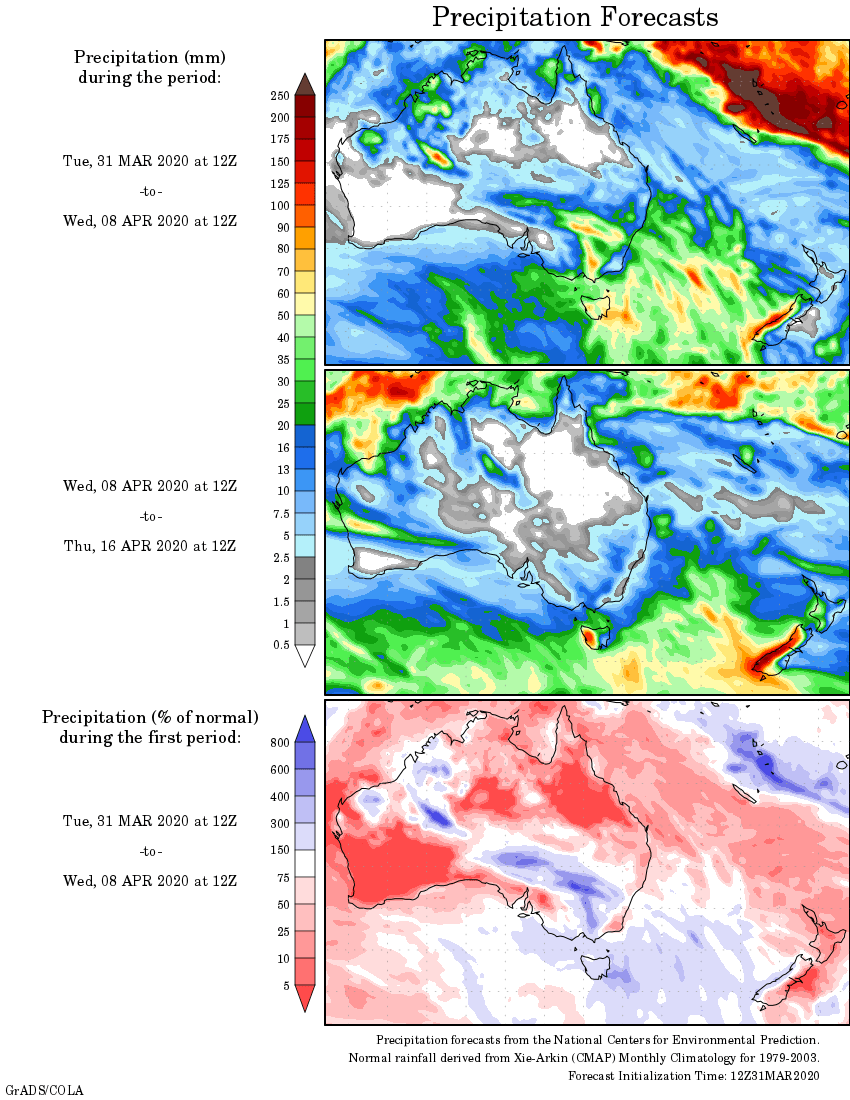
Rainfall outlook