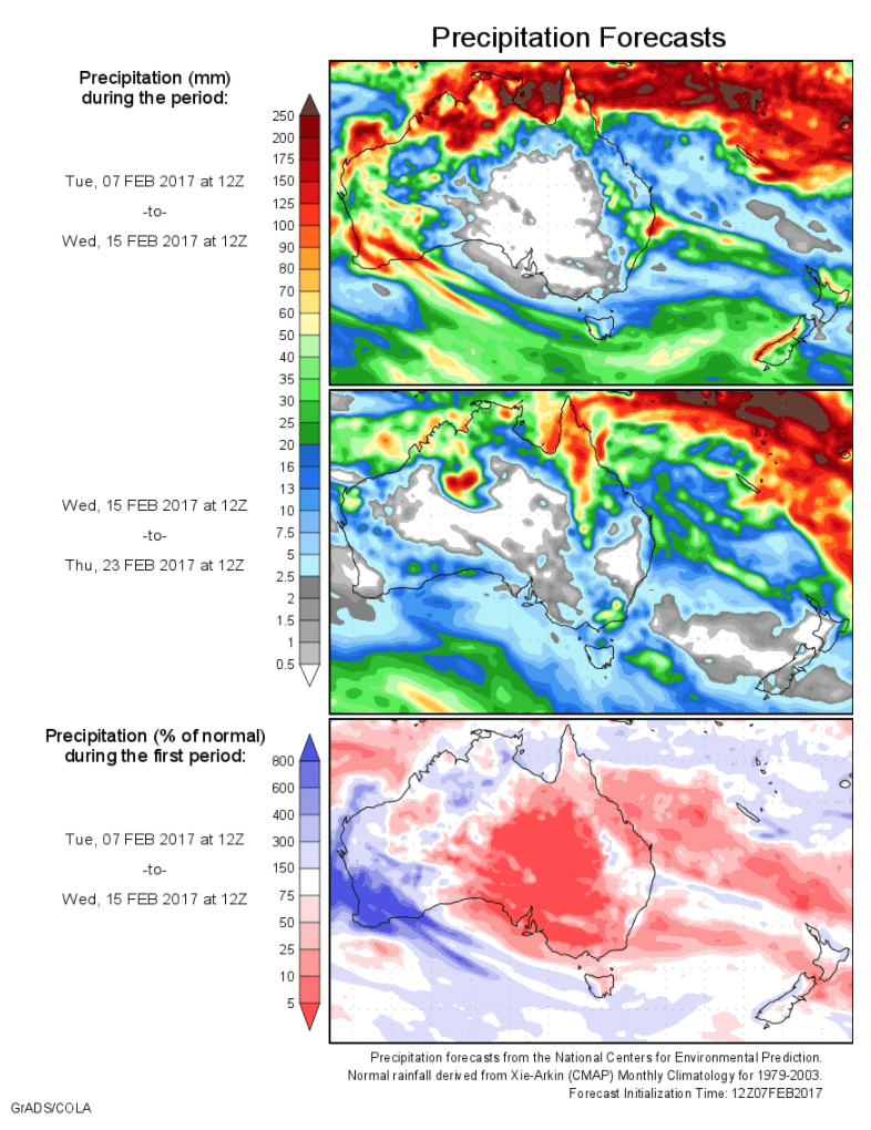
Today’s 14-day rainfall outlook – scroll to bottom of article
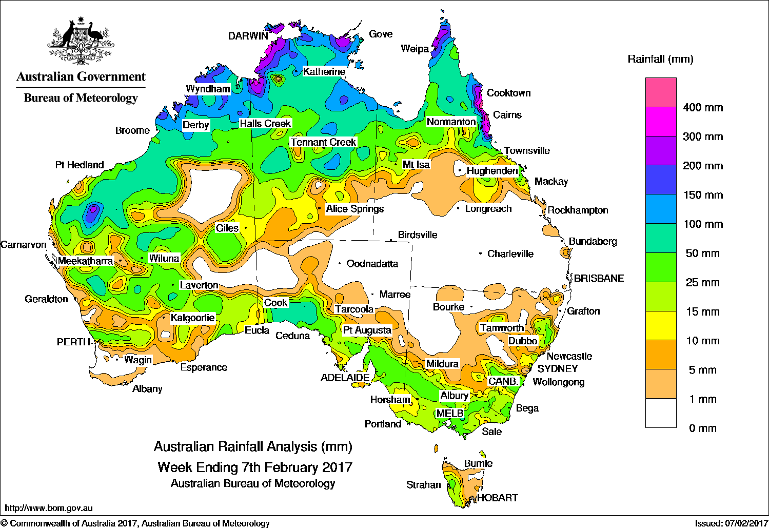
The biggest falls of the past week fell in the Kimberley and Top End regions, with more good falls in the southern Gascoyne, the Goldfields, central interior, Pilbara districts in Western Australia; western South Australia, central southern Victoria and north Queensland.
Rainfall totals between 10 mm and 50 mm were recorded in the central interior, southeast and parts of the west of Western Australia; southern South Australia; most of Victoria except East Gippsland, and western Tasmania. Similar totals were recorded in southeastern and eastern pockets of New South Wales; the southern part of northern Queensland, and through central and northern parts of the Northern Territory.
Past seven days: At the start of the week areas of rain, showers and thunderstorms were active in the vicinity of the monsoon trough, particularly in northern Australia. The monsoon trough extended to a tropical low pressure system located near Broome in Western Australia, and deepened, bringing heavy falls to the northern Gascoyne, and moderate falls to parts of the Pilbara and Kimberley. A surface trough along the west coast of Western Australia produced moderate falls across much of the South West Land Division, except the far southwest.
By the middle of the week, a surface trough extended from central parts of the Northern Territory to eastern New South Wales, triggering thunderstorms in parts of southeastern New South Wales, and producing moderate to heavy falls through central parts of the Northern Territory, and the central interior of Western Australia.
During the last part of the week, middle level cloud with embedded thunderstorm activity stretched across South Australia, Victoria, Tasmania and southern parts of New South Wales. Much of the activity was associated with surface and upper level troughs, and moderate falls were recorded in the southeast of Western Australia, and southern South Australia. Moderate falls continued across southeastern South Australia, most of Victoria, and southeastern New South Wales as the system tracked eastwards. Meanwhile, light falls were reported in western and eastern Tasmania in a westerly airstream. Heavy falls continued across northern Australia, with heavier falls reported near the Darwin–Daly region, and the western Kimberley around Broome, in association with the deepening low on the monsoon trough.
In the northeast, an upper-level low combined with a broad surface trough that extended over Queensland’s north tropical coast, enhancing shower and storm activity for much of the week, and producing heavy falls from about Cooktown to Cardwell. The highest weekly total was 588 mm at Daintree Village in northern Queensland.
Rainfall totals between 100 mm and 200 mm were recorded along the Kimberley coast; across much of the Top End of the Northern Territory, and central pockets of the Northern Territory; the Gulf Country; Cape York Peninsula and the north topical coast of Queensland, and an area of the southern Pilbara. Totals in excess of 300 mm were reported about the Darwin–Daly district, and the north tropical coast of Queensland.
Rainfall totals between 50 mm and 100 mm were recorded across parts of the southern Gascoyne, the Goldfields, central interior, Pilbara and Kimberley districts in Western Australia; the western agricultural district of South Australia; central and northern parts of the Northern Territory; a small area of central southern Victoria, and parts of north Queensland.
Rainfall totals between 10 mm and 50 mm were recorded in the central interior, southeast and parts of the west of Western Australia; southern South Australia; most of Victoria except East Gippsland, and western Tasmania. Similar totals were recorded in southeastern and eastern pockets of New South Wales; the southern part of northern Queensland, and through central and northern parts of the Northern Territory.
Little or no rainfall was recorded in central and western New South Wales, the southern half of Queensland, most of the Northwest and Northeast pastoral districts of South Australia, and in the southwest and pockets of the central interior of Western Australia.
Highest weekly totals list
New South Wales and Australian Capital Territory
110 mm Yarras (Mount Seaview)
51 mm Crookwell Post Office, Wingham (Lanark Close)
Victoria
82 mm Mount Hotham
57 mm Main Ridge
56 mm Ferny Creek
Queensland
588 mm Daintree Village
458 mm Mossman Central Mill
449 mm Mossman South Alchera Drive
Western Australia
195 mm Warmun
179 mm Country Downs
160 mm Marion Downs
South Australia
67 mm Nullarbor
57 mm Owen
54 mm Balaklava
Tasmania
78 mm Mount Read
41 mm Lake Margaret Power Station
39 mm Queenstown (South Queenstown)
Northern Territory
454 mm Geriatric Park
422 mm Channel Point
402 mm Dum In Mirrie Airstrip
More weekly rainfall totals:
- NSW/ACT totals click here
- Vic totals click here
- Qld totals click here
- WA totals click here
- SA totals click here
- Tas totals click here
- NT totals click here
Source: BOM