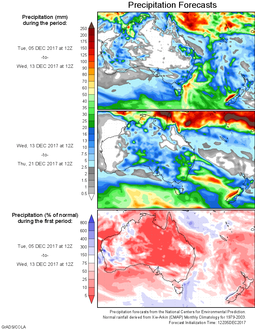
For today’s 14-day rainfall outlook – scroll to bottom of article
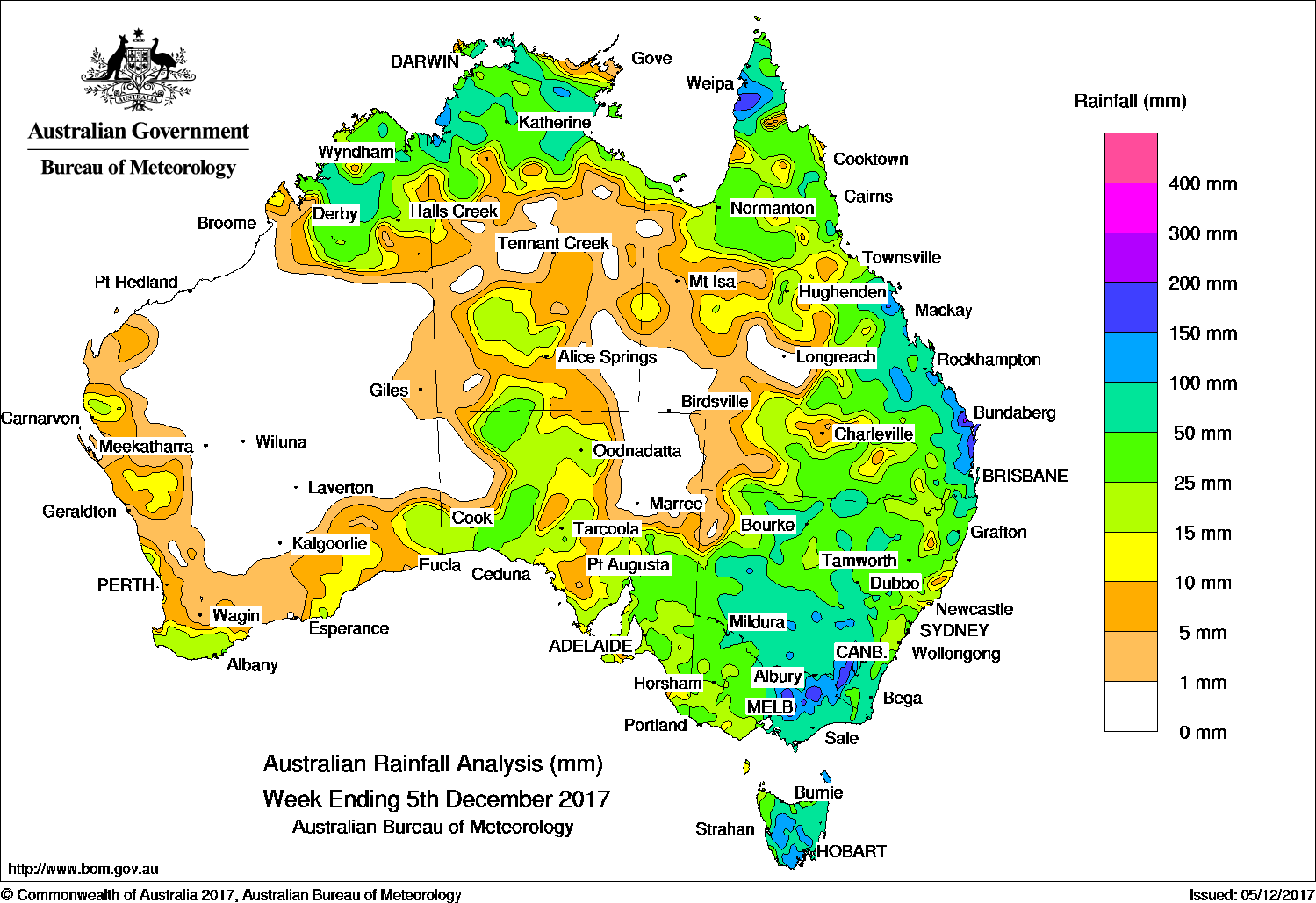
Surface troughs and upper level disturbances produced moderate falls across eastern and northern Australia, while moderate to locally heavy falls were recorded in southeastern Australia.
The highest weekly total was 210 mm at Stump Hill (Barjar) in northeastern Victoria.
Past seven days: At the beginning of the week, a broad surface low and associated upper level trough near the Western Australia–South Australia border produced an active line of thunderstorms, with moderate falls recorded over southeast Western Australia, South Australia and the Northern Territory. A surface trough over inland Queensland and northern New South Wales combined with an upper level disturbance, and produced extensive showers and thunderstorms over central and southern Queensland, and northern New South Wales.
In eastern Queensland, a moist onshore flow produced moderate falls along the east coast of Queensland from early in the week.
During the middle of the week, the combination of a broad area of low pressure and an upper level trough generated a cloudband with widespread thunderstorms extending from northwestern Australia through to central Australia, New South Wales, Victoria and Tasmania. Embedded thunderstorms extended across southeastern Australia, driven by tropical moisture combining with an upper level trough and an associated cut-off low over southern New South Wales. Moderate to heavy rainfall totals were recorded across the eastern half of Victoria, western and southern New South Wales, with moderate falls also over much of Tasmania.
Thunderstorms also developed through central Queensland, the northern half of the Northern Territory and northern Western Australia while rain continued along the ranges in eastern Australia and in Tasmania. A band of cloud with embedded thunderstorms extended along a surface trough from the Top End over the east coast of Queensland and into the Tasman Sea, wrapping around a low pressure system to the east of Tasmania.
At the end of the week, the low pressure centre intensified while located to the southeast of Tasmania, producing further rainfall over Tasmania. A surface trough was responsible for embedded thunderstorms and moderate rainfall totals over southeast Queensland and northeast New South Wales, with onshore flow bringing rain to southeastern New South Wales, and moderate to locally heavy falls from showers over the Kimberley.
Rainfall totals in excess of 200 mm were recorded in areas of northeastern Victoria, southeastern New South Wales, and southeastern Queensland. The highest weekly total was 210 mm at Stump Hill (Barjar) in northeastern Victoria.
Rainfall totals exceeding 100 mm were recorded in areas of the Kimberley, Top End, and Cape York Peninsula; in parts of Queensland’s east coast; southeastern New South Wales; northeastern Victoria, and southeastern Tasmania.
Rainfall totals between 50 mm and 100 mm were recorded in northern Western Australia, much of the Top End of the Northern Territory, the far north of the Cape York Peninsula, and in eastern Queensland. Similar totals were recorded in large areas of central and southern New South Wales, much of the eastern half of Victoria, and most of Tasmania.
Rainfall totals between 10 mm and 50 mm were recorded in areas along the west and south coasts of Western Australia and remaining parts of the Kimberley; in the Top End and Gulf Country and southern interior of the Northern Territory; and the southern half and central north of South Australia. Similar totals were recorded in western Victoria, remaining parts of New South Wales, remaining areas of Tasmania, and in eastern and southern Queensland.
Little or no rainfall was recorded in the Pilbara and much of the central interior of Western Australia, northeastern and northwestern South Australia, parts of the southeast and southwest of the Northern Territory and southwestern Queensland.
Highest weekly totals
New South Wales and Australian Capital Territory
159 mm Cabramurra AWS
151 mm Argalong (Sandy Creek)
150 mm Mount Ginini AWS
Victoria
210 mm Stump Hill (Barjarg)
207 mm Seven Creeks At Strathbogie
206 mm Kinglake West (Wallaby Creek)
Queensland
200 mm Double Island Point Lighthouse, Palmwoods
191 mm Nambour DAFF – Hillside
Western Australia
103 mm Mount House Airstrip
97 mm Mount House Station
86 mm Diggers Rest, Siddins Creek
South Australia
94 mm Boolcoomatta
71 mm Appila
63 mm Tailem Bend
Tasmania
142 mm Levendale
135 mm Yarlington (Blacks Pinnacle)
134 mm kunanyi (Mount Wellington), Koonya Heights
Northern Territory
123 mm Port Keats Airport
118 mm Douglas River Research Farm
113 mm Upper Seventeen Mile Creek
More weekly rainfall totals:
- NSW/ACT totals click here
- Vic totals click here
- Qld totals click here
- WA totals click here
- SA totals click here
- Tas totals click here
- NT totals click here
Source: BOM