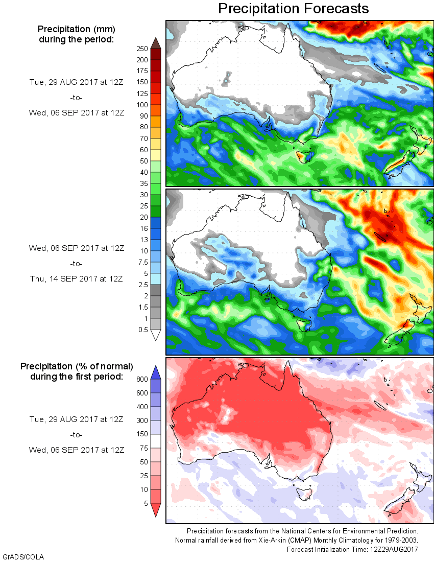
For today’s 14-day rainfall outlook – scroll to bottom of article
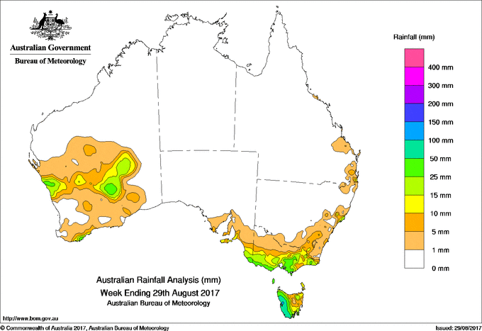
Mid-level troughs produced thunderstorms with moderate falls near west coast and inland Western Australia. A vigorous cold front produced light to moderate falls in Victoria and Tasmania later in the week.
Past seven days: At the start of the week, a number of weak cold fronts tracked across southeastern Australia, generating moderate falls in western Tasmania, then in southern parts of Victoria and southeastern South Australia. Widespread light falls were reported across remaining parts of Victoria and Tasmania.
During the middle of the weak, a surface trough produced light showers along parts of the Queensland and New South Wales east coasts. Meanwhile a mid-level trough and associated cloudband moved over Western Australia, producing isolated thunderstorms and moderate falls in the interior and along the State’s south coast.
In the last part of the week, a strong cold front tracked across southeastern Australia. The system produced widespread light to moderate falls in Victoria and moderate falls in western Tasmania. As the cold front moved eastwards, light rainfall totals were also recorded in southeastern New South Wales, and southwest Tasmania. In the west, thunderstorms formed along and near a deepening surface trough, generating some moderate rainfall totals in the Central West, with lights falls through the Southern Gascoyne down to the Eucla coast.
Rainfall totals exceeding 50 mm were recorded in western Tasmania, including the highest weekly total of 162 mm at Mount Read.
Rainfall totals between 25 mm and 50 mm were recorded in small areas in the Central West, Goldfields, and South Coastal districts in Western Australia; the extreme tip of southeastern South Australia; coastal western Victoria, West Gippsland and parts of the northeast; surrounding higher falls in western Tasmania; and an area of the New South Wales central coast.
Rainfall totals between 10 mm and 25mm were recorded surrounding higher falls in Western Australia and across the Goldfields District; about the southeast of South Australia including the Mount Lofty Ranges and Kangaroo Island; most of the southern half of Victoria and the northeast; and in southern and northeastern Tasmania. Similar totals were recorded in a small part of southeastern Queensland.
Little or no rainfall was recorded in north and east of Western Australia, the Northern Territory, South Australia away from the southeast, New South Wales away from the east coast, and almost all of Queensland away from the southeast.
Highest weekly totals
New South Wales and Australian Capital Territory
52 mm Bungwahl
39 mm Careys Peak (Barrington Tops)
33 mm Crawford River (Crawford)
Victoria
42 mm Mount Baw Baw, Warburton, Wonthaggi
Queensland
26 mm Wivenhoe Dam, Mt Tamborine Fern St
23 mm Canungra Finch Road
Western Australia
64 mm Manypeaks
60 mm Tamar
45 mm Windrush
South Australia
34 mm Mount Schank (Jethia)
27 mm Robe
25 mm Mount Gambier Aero
Tasmania
162 mmMount Read
96 mm Zeehan (West Coast Pioneers Mu
95 mm Queenstown (South Queenstown)
Northern Territory
0.6 mm Centre Island
More weekly rainfall totals:
- NSW/ACT totals click here
- Vic totals click here
- Qld totals click here
- WA totals click here
- SA totals click here
- Tas totals click here
- NT totals click here
Source: BOM