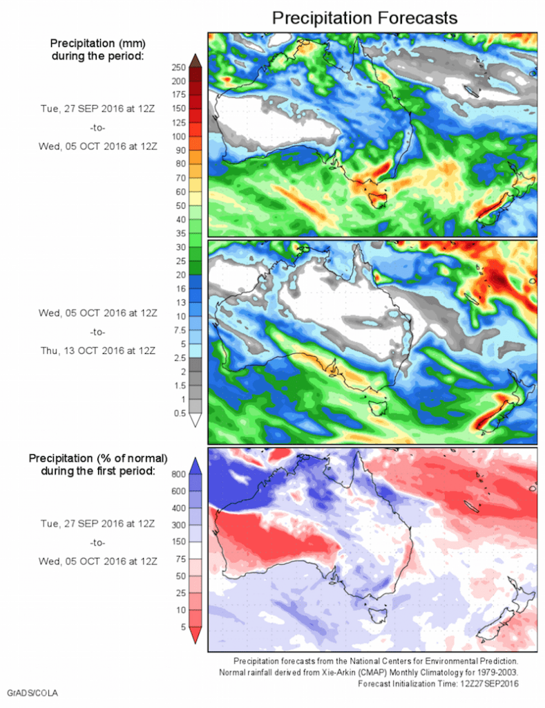
Today’s 14-day rainfall outlook – scroll to bottom of article
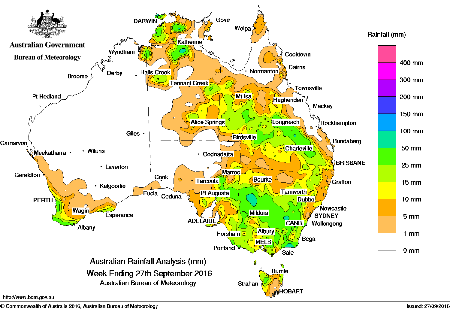
The biggest falls of the past week (50mm +) were recorded in Parts of eastern Victoria, pockets of western and central New South Wales, isolated parts of the Darwin–Daly region in the Northern Territory, and in central Queensland.
Past seven days: At the start of the week a broad surface and upper-level trough extended a cloudband from the Top End of the Northern Territory through central Australia, across much of Queensland and inland New South Wales. Showers and thunderstorms formed in the vicinity of the trough resulting in moderate falls across western, central, and southern Queensland, and in the northern and eastern parts of the Northern Territory.
At the beginning of the week a cold front and associated low pressure system tracked across southeast Australia, generating moderate falls in western and southern New South Wales, the northwest pastoral districts of South Australia, and northwest Victoria. The low pressure system tracked eastwards, and deepened over southern New South Wales before moving off the New South Wales coast. Widespread light falls were recorded from southeastern Queensland to eastern Victoria, with moderate falls reported locally across southern New South Wales and in parts of East Gippsland.
From the middle of the week, a series of cold fronts tracked across southern Australia. Light falls were recorded in southwest and southern parts of Western Australia, and across the agricultural district and Flinders Ranges in South Australia. The initial frontal system and an associated trough produced a cloudband with embedded storm cells that tracked across the southeast, and produced mostly light rainfall across New South Wales, Victoria, northern and western Tasmania, and southeastern South Australia. Moderate falls were recorded in parts of Murray Valley in South Australia, and the Wimmera district in Victoria, along with parts of central and western New South Wales.
50mm-100mm: Parts of eastern Victoria, pockets of western and central New South Wales, isolated parts of the Darwin–Daly region in the Northern Territory, and in central Queensland. The highest weekly total was 80 mm at Pirlangimpi Airport in the Northern Territory.
10mm- 50mm: Southwest and coastal southern Western Australia; in parts of the Top End, the Victoria River and Alice Springs districts in the Northern Territory; and across western, central and southern Queensland. Similar totals were also recorded in eastern South Australia and about the Eyre and Yorke Peninsulas, across most of Victoria, western and northeastern Tasmania, and most of New South Wales but generally excluding the coast north of Wollongong and areas of the inland north.
Little or no rainfall: Remaining parts of Western Australia, in the north, west and centre of South Australia, the west and south of the Alice Springs District and south of the Gulf in the Northern Territory, southeastern Tasmania, and northern and eastern Queensland.
Highest weekly totals list
New South Wales and Australian Capital Territory
75 mm Ginninderra (Charnwood (Act))
73 mm Stockinbingal General Store
68 mm Menindee Post Office
Victoria
85 mm Cabbage Tree Creek
79 mm Mount Baw Baw
64 mm Cann River
Queensland
56 mm Spring Creek Station
51 mm Kinnoul
50 mm Wyseby
Western Australia
48 mm Walpole
47 mm Northcliffe, Walpole Forestry
South Australia
42 mm Wilpena (Oraparinna)
41 mm Leigh Creek Airport
38 mm Koonamore
Tasmania
44 mm Lake Margaret Power Station
39 mm Mount Read
32 mm Swan Island
Northern Territory
80 mm Pirlangimpi Airport
61 mm Elizabeth Valley
59 mm Walker Creek
More weekly rainfall totals:
- NSW/ACT totals click here
- Vic totals click here
- Qld totals click here
- WA totals click here
- SA totals click here
- Tas totals click here
- NT totals click here
Source: BOM