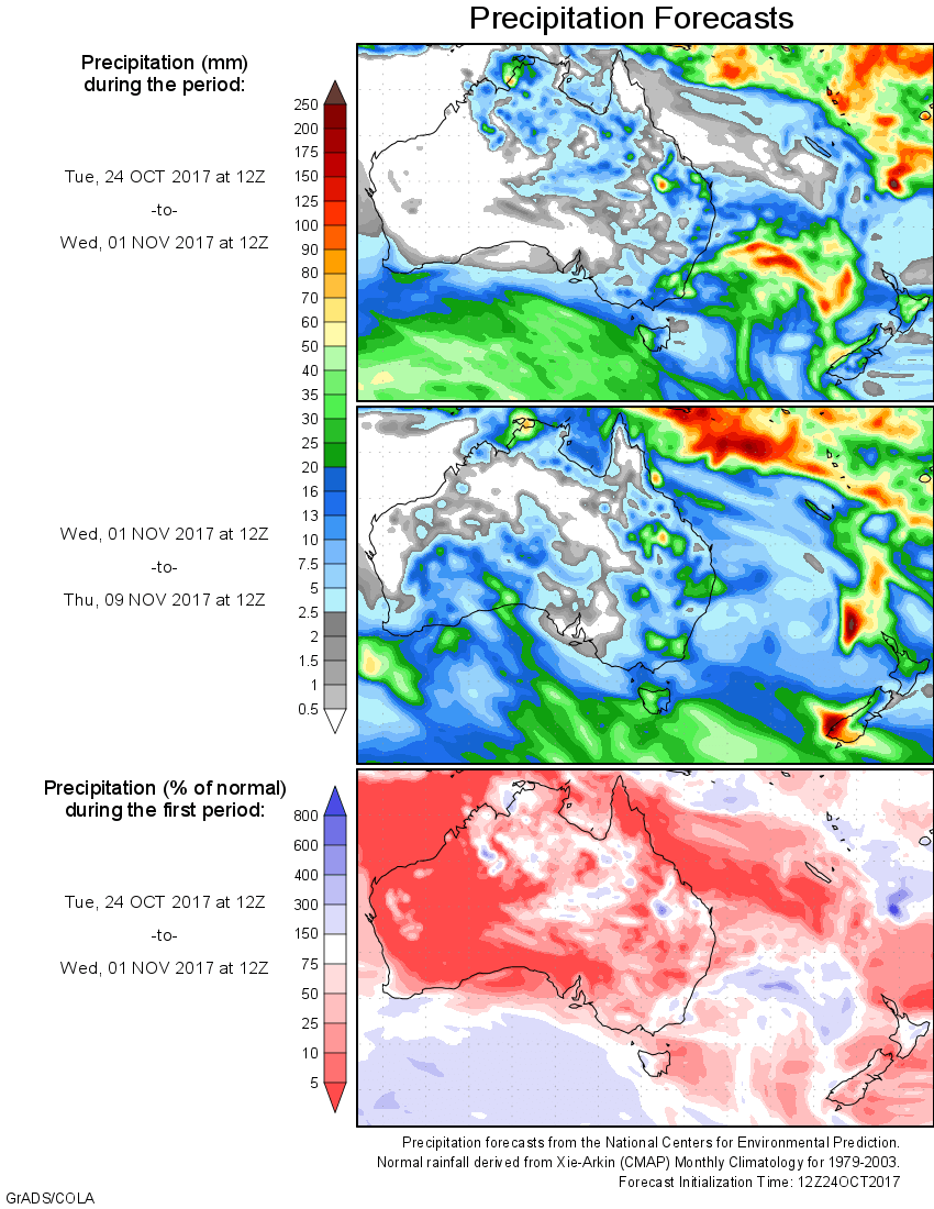
For today’s 14-day rainfall outlook – scroll to bottom of article
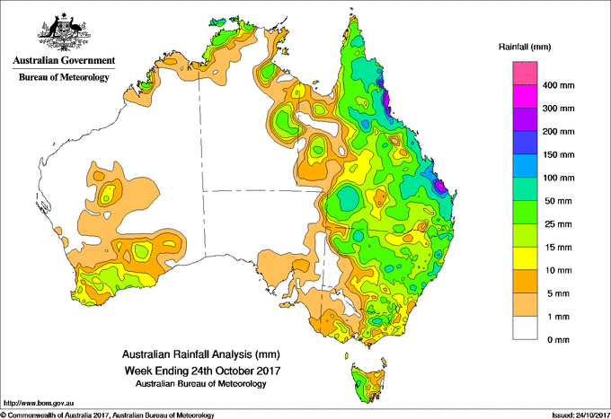
An extensive cloudband and surface trough became associated with a cold front producing moderate to locally heavy falls between southwestern Queensland and eastern Victoria. Rainfall was also recorded in southwest Western Australia, the coastal Kimberley and northwest Top End, parts of the Gulf Country and most of the remainder of Queensland, the majority of New South Wales, southeastern South Australia, southern and eastern Victoria, and Tasmania.
At the start of the week, an upper level low over northern Queensland interacted with a moist air mass, while a low level trough was located near the Wide Bay and Capricornia coasts. Widespread, moderate rainfall resulted across large parts of eastern Queensland from Cape York Peninsula to the Sunshine Coast. Some daily totals exceeding 250 mm were recorded around Bundaberg in the Wide Bay and Burnett District, with riverine flooding in Baffle Creek, the Kolan and the Burnett Rivers. Further north, heavy falls were reported in the North Tropical Coast, and Herbert and Burdekin districts, with local totals exceeding 200 mm around Tully.
Isolated showers and storms also produced moderate totals about Darwin and areas south of the Gulf early in the week. In the south, a weak cold front brought mainly light falls to far southwest Western Australia. As the cold front tracked eastward light to moderate falls were recorded in southeastern South Australia, southwestern Victoria, and western Tasmania.
During the middle of the week, an extensive cloudband and surface trough became associated with the cold front. Moderate to locally heavy falls were recorded between southwestern Queensland and eastern Victoria, with light falls in western Tasmania. In northern Queensland, a weakening upper level low over Cape York Peninsula combined with a moist air mass to produce scattered showers and thunderstorms in the northeast.
The cloudband then extended north along a surface trough across inland Queensland, assisted by an upper level disturbance. Moderate to locally heavy showers resulted from the Gulf Country, through central and southern Queensland to the northeast quarter of New South Wales. As the surface trough moved eastward further moderate falls were recorded along most of Queensland’s east coast, and far northeastern New South Wales.
In the west, a coastal trough deepened along the west coast of Western Australia from mid-week, producing light to moderate falls across much of the south of the State, with scattered light falls further inland
At the end of the week isolated thunderstorms formed on a trough along the east coast, with moderate falls recorded in coastal New South Wales, southeastern, central and northeastern Queensland. Isolated thunderstorms also developed over the far Top End of the Northern Territory.
The highest weekly total was 471 mm at Makowata, located between Bundaberg and Rockhampton in Queensland. Rainfall totals near or exceeding 300 mm were reported at locations in Queensland’s Central Coast District and around Tully on the North Tropical Coast. Totals exceeding 200 mm were recorded surrounding higher falls on the North Tropical Coast and at some locations around Bundaberg.
Rainfall totals between 100 mm and 200 mm were recorded in the Wide Bay and Burnett, and Capricornia districts, and the North Tropical Coast.
Rainfall totals between 50 mm and 100 mm were recorded in isolated parts of northeastern Victoria, western Tasmania and eastern, central and northwestern New South Wales, as well as around Darwin. Similar totals were recorded in southwestern Queensland and along much of the State’s east coast.
Rainfall totals between 10 mm and 50 mm were recorded in southwestern Western Australia and parts of the Kimberley coast, much of southern and eastern Victoria, and parts of western Tasmania. Similar totals were recorded across most of New South Wales except the southwest, in most of Queensland except the far west and in some areas of the Gulf Country, and in the Northern Territory south of the Gulf and about the Darwin–Daly coast.
Little or no rainfall was recorded the remaining parts of Western Australia and the Northern Territory; most of South Australia; and areas of northwestern Victoria, eastern Tasmania, far western Queensland and southwestern New South Wales.
Highest weekly totals
New South Wales and Australian Capital Territory
102 mm Yarras (Mount Seaview)
101 mm Old Bar (Eucalypt Close)
95 mm Mooral Creek (The Den)
Victoria
80 mm Myrrhee (Boggy Ck At Angleside
72 mm Eurobin
60 mm Falls Creek (Rocky Valley)
Queensland
471 mm Makowata
417 mm Rosedale Post Office
359 mm Babinda Post Office
Western Australia
34 mm Narrogin
31 mm Kalumburu
30 mm Chidlow
South Australia
11 mm Carrieton, Lake George, Mount Gambier Aero
Tasmania
106 mm Mount Read
60 mm Queenstown (South Queenstown)
48 mm Zeehan
Northern Territory
131 mm Pirlangimpi Airport
78 mm Mcminns Lagoon, Gunn Point
More weekly rainfall totals:
- NSW/ACT totals click here
- Vic totals click here
- Qld totals click here
- WA totals click here
- SA totals click here
- Tas totals click here
- NT totals click here
Source: BOM