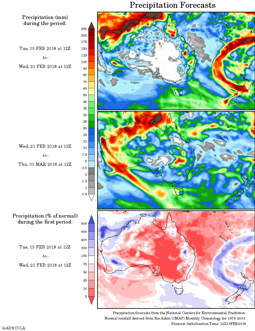
For today’s 14-day rainfall outlook – scroll to bottom of article
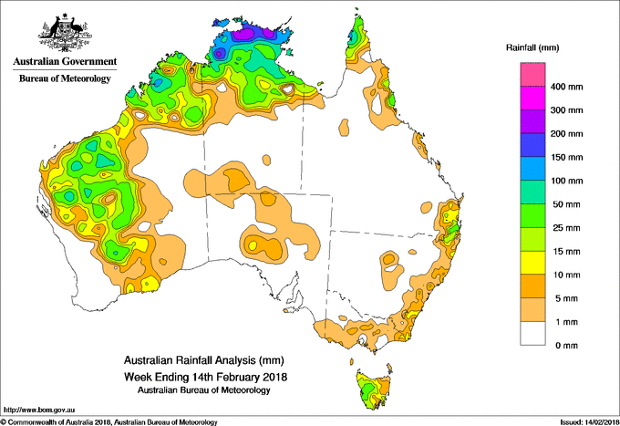
Broad areas of low pressure across northern Australia produced storms and showers. A deepening surface trough and low pressure system inland of the west coast of Western Australia produced moderate falls.
Past seven days: At the beginning of the week, a broad trough of low pressure extended from the Top End of the Northern Territory through to the Cape York Peninsula and enhanced thunderstorm activity over the Top End, Gulf Country and northern tropics in Queensland for most of the week. Another low pressure trough stretching from the Gascoyne down the south coast of Western Australia resulted in thunderstorms. Showers and thunderstorms continued in northwestern Australia about the Kimberley and Pilbara districts for several days. In the east, a moist onshore flow produced showers with moderate falls about the north tropical Queensland coast.
The passage of a weak cold front brought some light falls to western Tasmania early in the week.
During the middle of the week, an inland surface trough extended through the interior of the country, from central Western Australia, across South Australia to the central coast of New South Wales. Thunderstorms developed in eastern New South Wales, near and along the trough, with mostly light falls associated with the storms.
At the end of the week, a cold front and associated surface trough tracked over southeastern Australia. Thunderstorms and showers produced moderate falls in western Tasmania, with light falls in eastern Tasmania, eastern and central Victoria, and southeastern New South Wales. A broad surface trough and associated a low pressure centre, just inland from the west coast produced moderate falls in the southern Pilbara and across much of the Gascoyne district in Western Australia.
A developing monsoon trough with a weak tropical low pressure system located in the northwestern Top End also produced moderate falls to the far northern Australia at the end of the week. Rainfall totals exceeding 200 mm were recorded in a small part of the northwest Top End in the Northern Territory, including the highest weekly total of 203 mm at Point Stuart in the Darwin–Daly district.
Rainfall totals exceeding 100 mm were recorded in, the northern Top End in the Northern Territory, parts of the northwest Cape York Peninsula and a small area in the north tropical Queensland coast.
Rainfall totals between 50 mm and 100 mm were recorded in patchy areas of the Kimberley, Pilbara and Gascoyne, the Top End and Gulf Country in the Northern Territory, and Cape York Peninsula and much of the north tropical Queensland coast.
Rainfall totals between 10 mm and 50 mm were recorded in the Kimberley and in the western half of Western Australia away from the coast; the Top End in the Northern Territory and in parts of the Gulf Country; along the central and southeast Queensland coast; pockets of the east coast of New South Wales; far eastern Victoria, and western and southern Tasmania.
Little or no rainfall was recorded in remaining parts of Western Australia, South Australia, the southern half of the Northern Territory, most of Queensland away from the far north and east coast, and the western half of Victoria.
Highest weekly totals list and map
New South Wales and Australian Capital Territory
70 mm Ulladulla AWS
31 mm Yarras (Mount Seaview)
24 mm Dairy Flat
Victoria
14 mm Gabo Island Lighthouse, Mallacoota
13 mm Gooram (Hillside), Seven Creeks At Strathbogie
Queensland
176 mm Reef Park
170 mm Mossman South Alchera Drive
167 mm Low Isles Lighthouse
Western Australia
86 mm Mingah Springs
83 mm Dalgety Downs
82 mm Country Downs
South Australia
6 mm Tarcoola Aero
4 mm Tarcoola (Mulgathing)
1.8 mm Nairne
Tasmania
46 mm Mount Read
30 mm Triabunna (Salmons Flats)
27 mm Lake Margaret Power Station
Northern Territory
203 mm Point Stuart
202 mm Milingimbi Airport
197 mm Oenpelli Airport
More weekly rainfall totals:
- NSW/ACT totals click here
- Vic totals click here
- Qld totals click here
- WA totals click here
- SA totals click here
- Tas totals click here
- NT totals click here
Source: BOM