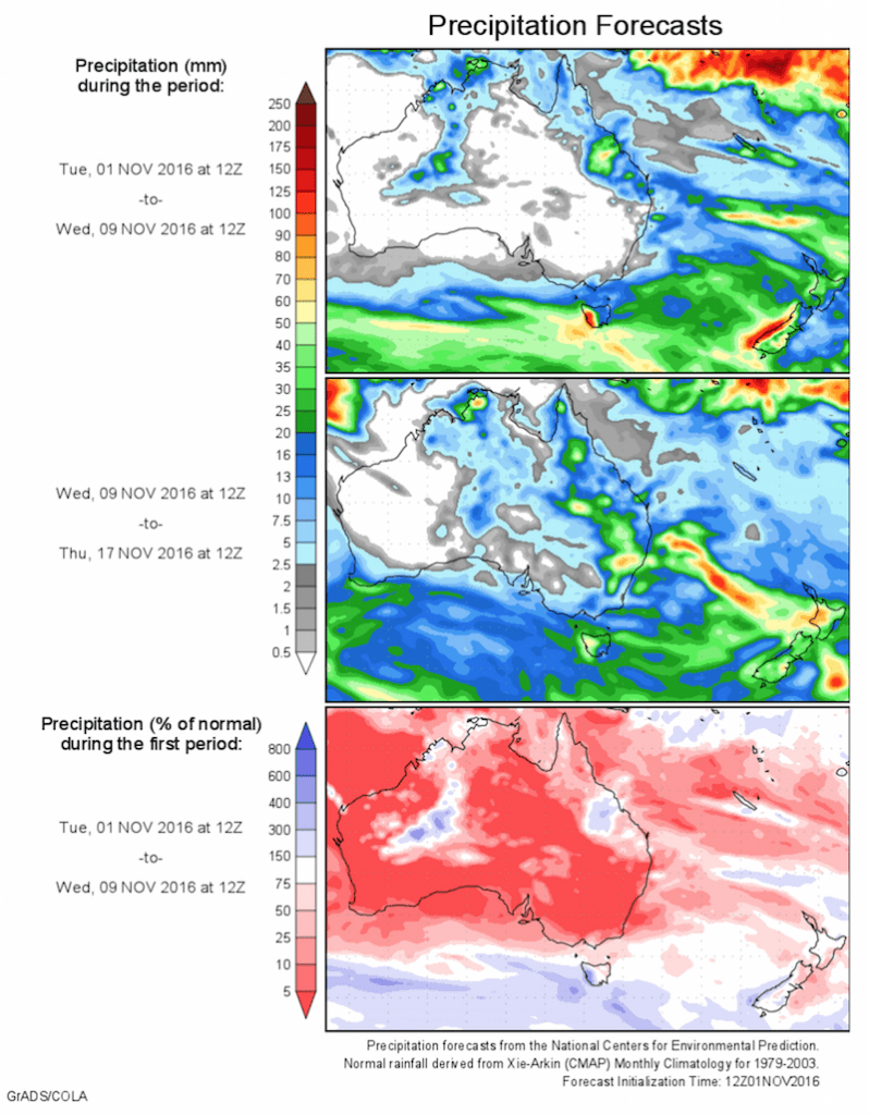
Today’s 14-day rainfall outlook – scroll to bottom of article
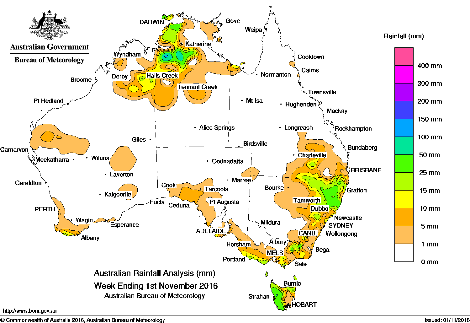
Small areas of western Tasmania, inland parts of the Northern Territory, and eastern New South Wales received the highest falls in the past week.
Past seven days: At the start of the week, a surface trough extending from central Western Australia to Victoria moved slowly eastward, and a number of weak cold fronts embedded in a westerly stream tracked the Bass Strait. Light falls were recorded along parts of the southern coasts of Western Australia, South Australia and western Victoria, with moderate falls recorded over parts of western Tasmania.
During the middle of the week, isolated showers and thunderstorms developed over northeastern New South Wales and southeastern Queensland, in association with an inland surface trough and a high pressure ridge along the east coast. Moderate falls were recorded in the Mid North Coast and Northern Rivers in New South Wales. A weak cold front brushed the southwest, generating light falls on the southwest and southern coasts of Western Australia.
At the end of the week, a cloudband extended through central Australia to the southeast, with an associated surface trough and cold front tracking across Victoria, New South Wales and Tasmania.
Moderate falls were recorded in parts of eastern New South Wales, eastern and southern Victoria, and western and northern Tasmania.
Thunderstorms and showers were confined to the northern Darwin region at the start and middle of the week. Storms with moderate to heavy falls were reported over a broad area from parts of the east Kimberley in Western Australia to the northwestern Northern Territory at the end of the week.
50-100mm: Small areas of western Tasmania, inland parts of the Northern Territory, and eastern New South Wales. The highest weekly total was 104 mm at McMinns Lagoon in the Northern Territory.
10-50mm: Southwest and eastern Kimberley region of Western Australia, the northwestern Northern Territory, a small area of Kangaroo Island in South Australia and in southern and northeastern parts of Victoria. Similar totals were recorded in western and northern Tasmania, parts of eastern and northeastern New South Wales and pockets of southern Queensland.
Little or no rainfall: Western Australia except the southwest and Kimberley, the Northern Territory away from the Top End, most of South Australia, central and northwestern Victoria, eastern Tasmania, central and western New South Wales and the remaining parts of Queensland.
Highest weekly totals list and map
New South Wales and Australian Capital Territory
78 mm Yarras (Mount Seaview)
62 mm Wittitrin
57 mm Thredbo Village
Victoria
39 mm Lorne (Mount Cowley)
36 mm Benwerrin
34 mm Beech Forest
Queensland
43 mm Yangan Post Office
29 mm Carneys Creek The Ranch
27 mm Karoola Park
Western Australia
28 mm Moola Bulla Airstrip
17 mm Shannon
16 mm Halls Creek Comparison
South Australia
17 mm Mount Schank (Jethia)
13 mm Mount Gambier Aero
12 mm Cape Borda, Flinders Chase (Rocky River)
Tasmania
73 mm Mount Read
60 mm Lake Margaret Power Station
45 mm Queenstown (South Queenstown)
Northern Territory
104 mm McMinns Lagoon
90 mm Delamere Weapons Range
88 mm Kidman Springs
More weekly rainfall totals:
- NSW/ACT totals click here
- Vic totals click here
- Qld totals click here
- WA totals click here
- SA totals click here
- Tas totals click here
- NT totals click here
Source: BOM