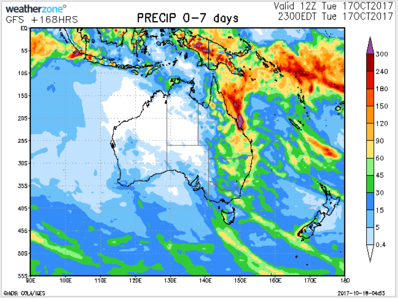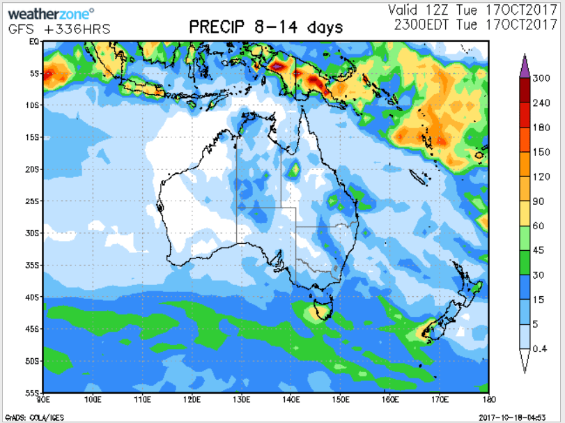
For today’s 14-day rainfall outlook – scroll to bottom of article
Surface troughs generated thunderstorms and showers with moderate falls in western, northern and eastern Australia. A coastal trough produced persistent, heavy rainfall in eastern Queensland and parts of northeastern New South Wales.
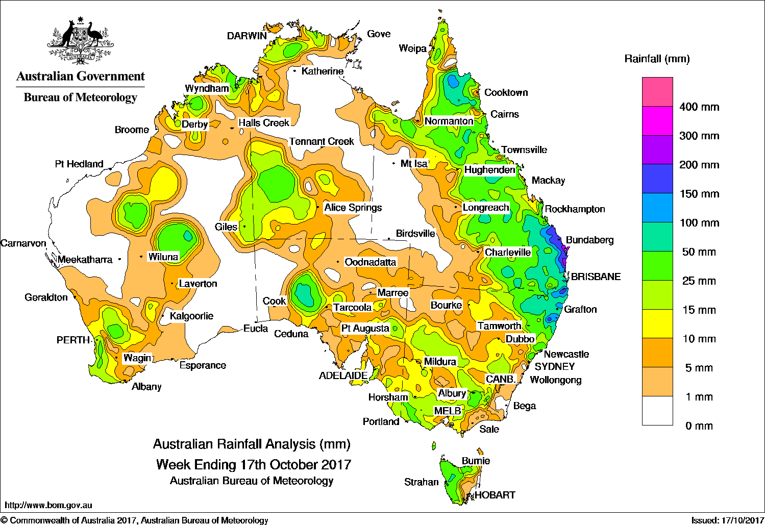
Past seven days: At the start of the week, a broad surface trough through central parts of the county was associated with thunderstorm activity, generating moderate falls in Central Australia and parts of southwestern South Australia. The surface feature interacted with an upper-level disturbance, with an extensive cloudband and embedded thunderstorms extending from the northern interior through South Australia, into southeastern Australia. Widespread moderate falls were recorded in southern Queensland, most of New South Wales, Victoria, Tasmania and eastern South Australia.
The surface trough migrated eastwards and deepened, extending across inland Queensland through the middle of the week while a series of upper level troughs maintained instability over much of the State. Moderate to locally heavy falls resulted in central to southeast Queensland, and in the north central coast of New South Wales.
A broad area of low pressure also produced convective cloud with thunderstorms developing about the northern Kimberley, western areas of the Northern Territory, and around Alice Springs in the middle of the week.
A surface trough then rapidly deepened near the west coast of Western Australia, with thunderstorms and showers developing near the trough. Isolated, moderate to locally heavy falls were recorded in the northern South West Land Division, through the central interior, eastern parts of the Pilbara, and the northern Kimberley.
During the last part of the week, the surface trough stretching across Queensland’s interior shifted west, extending a moist air mass through most of the State. An upper level low over the southern interior combined with the air mass, resulting in showers and storms over most of eastern Queensland and northeastern New South Wales. The upper level disturbance shifted slowly northwards and into the northeast tropics, while a low level trough moved westwards across the Coral Sea towards the east tropical and Capricornia coasts. Moderate to heavy falls were recorded about the Sunshine Coast and Wide Bay and Burnett District. Further moderate to locally heavy falls were recorded between Cape York Peninsula and northeastern New South Wales, as well as lighter falls about the Gulf and Top End. In the west, a strong cold front produced moderate rainfall in southwest Western Australia
Rainfall totals exceeding 200 mm were recorded in parts of the Wide Bay and Sunshine Coast areas in southeast Queensland. The highest weekly total was 304 mm at Eumundi in southeast Queensland. Rainfall totals in excess of 150 mm were recorded between Seventeen Seventy and Caloundra in southeast Queensland, and around Murwillumbah in the Northern Rivers District, and about Coffs Harbour in the Mid North Coast District of New South Wales.
Rainfall totals between 50 mm and 150 mm were recorded in parts of Queensland around Cooktown in the eastern Cape York Peninsula, in pockets from the north tropical coast to central Queensland, and a large area from central Queensland down to northeastern New South Wales. Similar totals were recorded in isolated locations in Queensland’s Gulf Country, the Central Wheat Belt in Western Australia, southwest South Australia and western Tasmania.
Rainfall totals between 10 mm and 50 mm were recorded in parts of the Kimberley, central and southwest Western Australia; in the Top End and the west of the Northern Territory; in southwestern and parts of eastern South Australia; western, central and much of northern Victoria, and western and northern Tasmania. Similar totals were recorded in southern and northeastern New South Wales, and surrounding higher falls in eastern and northern Queensland.
Little or no rainfall was recorded in the northwest and east of Western Australia, south of the Kimberley, western and most of northern South Australia, much of the eastern half of the Northern Territory, western Queensland, northwest and southeast New South Wales, and a small area of eastern Victoria.
Highest weekly totals
New South Wales and Australian Capital Territory
168 mm Green Pigeon (Morning View)
167 mm Coffs Harbour Airport
166 mm Eungella (Oxley River)
Victoria
59 mm Falls Creek (Rocky Valley)
42 mm Falls Creek
40 mm Huon (Barkleys Camp)
Queensland
304 mm Eumundi – Crescent Rd
288 mm Sandy Cape Lighthouse
263 mm Noosaville
Western Australia
56 mm Ygnattering
52 mm Tammin
51 mm Spring Valley
South Australia
48 mm Crafers (Mt Lofty)
42 mm Tarcoola (Mobella)
36 mm Tarcoola (Mulgathing)
Tasmania
94 mm Mount Read
53 mm Lake Margaret Power Station
46 mm Zeehan
Northern Territory
53 mm Mount Bundey South
More weekly rainfall totals:
- NSW/ACT totals click here
- Vic totals click here
- Qld totals click here
- WA totals click here
- SA totals click here
- Tas totals click here
- NT totals click here
Source: BOM, Weatherzone