For today’s 14-day rainfall outlook – scroll to bottom of article
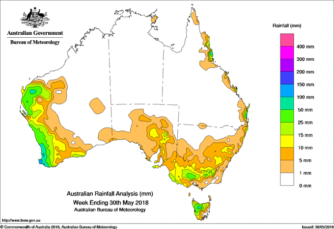
A strong cold front tracked across southern Australia, generating moderate falls along the west coast and parts of southeastern Australia. Moist, onshore airflow produced moderate falls along parts of the exposed east coast of Queensland and northeastern New South Wales.
Past seven days: At the start of the week a high pressure system in the Bight directed a cool southwesterly flow over Victoria, parts of New South Wales and South Australia, with an embedded cold front passing Tasmania. This resulted in light falls about southeastern South Australia, southern Victoria, and western Tasmania.
From the middle of the week, a very strong cold front approached the west coast of Western Australia, with an associated deep low pressure system to the southwest of the State. As the systems tracked eastwards, a thick cloudband with embedded thunderstorms generated moderate falls along the west coast from about Onslow in the Pilbara to the far southwest coast of Western Australia. Heavier falls were recorded in the Perth hills and between Busselton and Augusta in the far southwest of Western Australia. Widespread, light falls were reported in the central and southern parts of the State.
As the cold front weakened and progressed through the interior of Western Australia, cloud streamed across central Australia and South Australia, producing light falls across parts of the Northwest Pastoral district, and large parts of eastern South Australia to western Victoria. Moderate falls were recorded in the Flinders and Mid North districts of South Australia.
In the last part of the week, a subsequent weaker cold front tracked through the south coasts of Western Australia and South Australia, bringing isolated moderate falls. The cold front then moved through Victoria and New South Wales, and connected to a developing low pressure system west of Tasmania. A middle to high level cloudband with isolated thunderstorms formed ahead of the front, with cold air behind the front combining with a small, secondary low pressure system. This resulted in moderate falls across central and southwestern Victoria, and in northern Tasmania. Widespread light falls were also reported along the southern coast of South Australia, most of western Victoria, and southwestern New South Wales.
In the east, a persistent and moist onshore airflow generated coastal showers throughout the week, and produced moderate falls about the north tropical, central and southeast coasts of Queensland; also about the northeastern New South Wales coast.
Rainfall totals in excess of 100 mm were recorded in the far southwest of Western Australia, and in small areas of the north tropical and southeast coasts of Queensland. The highest weekly total was 140 mm at Bickley in the Perth hills in Western Australia.
Rainfall totals between 50 mm and 100 mm were recorded in a small area of the Pilbara, and along the southwest coast of Western Australia.
Rainfall totals between 10 mm and 50 mm were recorded along the west coast and adjacent inland districts from the west Pilbara and the Gascoyne, down to the South West Land Division of Western Australia; in the Flinders District, adjacent parts of the Northwest Pastoral District and in parts of southeastern South Australia; in the southwest and central areas of Victoria; northwestern Tasmania; and along the coastal fringe in northeastern New South Wales, and the north tropical, central and southeast coasts of Queensland.
Little or no rainfall was recorded in Western Australia away from the western and southern coasts, much of northern and western South Australia, the Northern Territory, most of Queensland except along the exposed east coast, most of New South Wales away from the northeast coast, eastern Victoria, and southern and eastern Tasmania.
Highest weekly totals
New South Wales and Australian Capital Territory
39 mm Kingscliff (Marine Parade)
29 mm Ballina Airport AWS
26 mm Evans Head RAAF
Victoria
25 mm Kinglake West
22 mm Merton (Enderlee)
21 mm Portland (Cashmore Airport)
Queensland
112 mm Sunshine Coast Airport
97 mm Tewantin RSL Park
95 mm Caloundra Airport
Western Australia
140 mm Bickley
128 mm Acton Park
117 mm Dwellingup
South Australia
21 mm Mount Gambier Aero
19 mm Flinders Chase (Rocky River)
17 mm Leigh Creek Airport
Tasmania
35 mm Mount Read
32 mm Barrington Post Office
30 mm Loongana (Serendipity)
Erriba (Jubb Road)
Northern Territory
6 mm Alcan Minesite, Gove Airport
0.6 mm Centre Island
More weekly rainfall totals:
- NSW/ACT totals click here
- Vic totals click here
- Qld totals click here
- WA totals click here
- SA totals click here
- Tas totals click here
- NT totals click here
Source: BOM
Rainfall outlook:
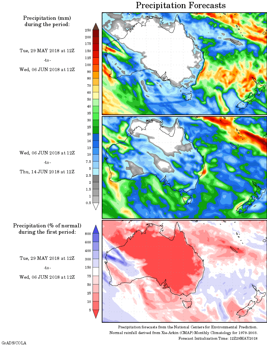
Source: Weatherzone