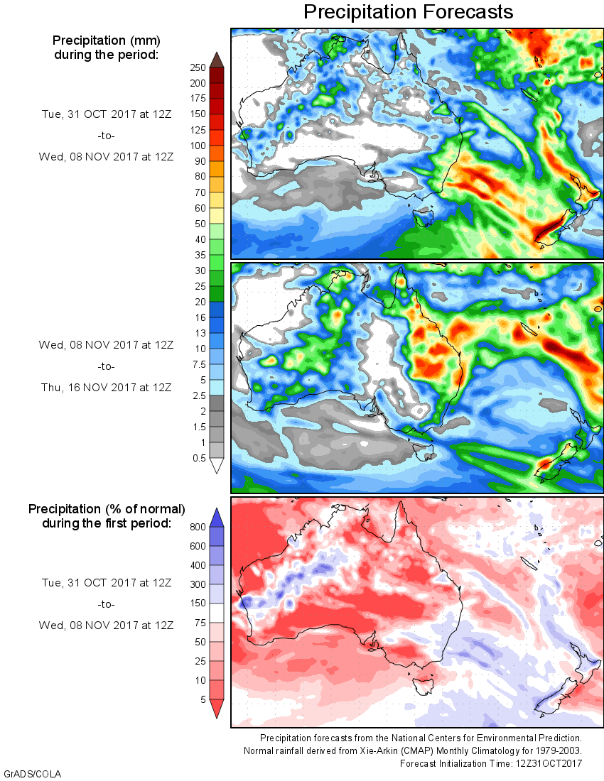
For today’s 14-day rainfall outlook – scroll to bottom of article
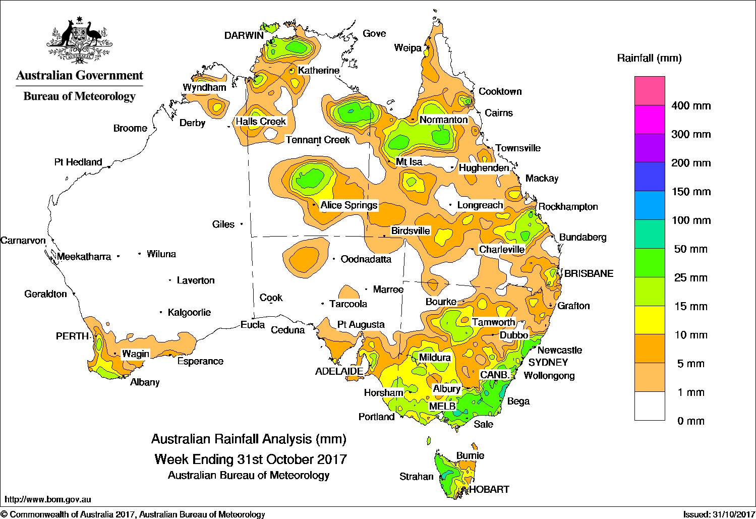
A complex low pressure system produced storms and moderate falls in eastern New South Wales, while surface troughs across northern and eastern Australia generated showers and thunderstorms throughout the week.
The highest weekly total was 110 mm at Dalmeny in eastern New South Wales.
Past seven days: At the start of the week, a low pressure system and associated surface trough tracked across southeastern Australia. Widespread, light falls were recorded in southeastern South Australia, Victoria and parts of southern Tasmania. Thunderstorms produced moderate falls in central southern Victoria. As the surface trough and low tracked eastwards, further light falls were recorded in western and eastern Victoria and along the east coast of New South Wales.
Around the middle of the week, the low pressure system became centred over southeastern New South Wales and interacted with another low located near Lord Howe Island, becoming a complex system that produced widespread bands of thunderstorm activity. Moderate to locally heavy falls were recorded south of Taree on the mid- New South Wales coast and in adjacent inland districts, along with isolated moderate falls in central western parts of the State. Mainly light falls were recorded from central to southeastern Queensland as thunderstorms formed east of a surface trough that extended through inland Queensland. In the west, a cold front swept across the southwest of Western Australia, producing mostly light falls in the South West Land Division.
In the last part of the week, a frontal system and associated surface trough stretched from the Top End in the Northern Territory to south of Tasmania, with an embedded low pressure system located over northern New South Wales. Isolated moderate falls from localised thunderstorms were recorded in southern parts of the Northern Territory, northern New South Wales and eastern Victoria.
A strong frontal system tracked over southeastern Australia at the end of the week, with widespread light falls reported in southeastern South Australia and Victoria, and moderate falls in western Tasmania. In the north, a broad area of low pressure extending across northern Australia and through Queensland generated showers and thunderstorms about the Top End, Gulf Country and central Australia as well as northern and eastern Queensland.
Rainfall totals between 50 mm and 100 mm were recorded in an area of western Tasmania, pockets of eastern Victoria and in parts of the south coast of New South Wales. The highest weekly total was 110 mm at Dalmeny (Binalong St) in eastern New South Wales.
Rainfall totals between 10 mm and 50 mm were recorded in the southwest and far north of Western Australia, northwestern and parts of the south of the Northern Territory, about the Gulf Country and in central and southeastern Queensland. Similar totals were recorded in southwest, central and eastern New South Wales, across most of Victoria, Tasmania except the northeast and in southeastern South Australia.
Little or no rainfall was recorded in remaining parts of Western Australia, the northeast, central and southwest of the Northern Territory, in pockets of central and southwest Queensland, northwestern New South Wales and South Australia away from the southeast.
Highest weekly totals
New South Wales and Australian Capital Territory
110mm Dalmeny (Binalong St)
93 mm Nelligen (Thule Road)
Victoria
69mm Valencia Creek (Little Plain)
Queensland
99mm Currajong
44mm Fernvale – Burns St
Western Australia
30 mm PembertonNorth Walpole
28 mm Dwellingup
South Australia
31mm Cudlee Creek (O’Deas Road)
29mm Cudlee Creek
Tasmania
69mm Mount Read
50mm Zeehan (West Coast Pioneers Mu
47mm Savage River Mine
Northern Territory
55mm Batchelor Airport, Labelle Downs,
48mm The Chase
More weekly rainfall totals:
- NSW/ACT totals click here
- Vic totals click here
- Qld totals click here
- WA totals click here
- SA totals click here
- Tas totals click here
- NT totals click here
Source: BOM