A COLD front crossed Victoria, Tasmania and southern New South Wales on April 30, bringing light to moderate rainfall; the highest daily rainfall totals were recorded between the Illawarra and the Hunter districts in NSWs.
Moist onshore flow directed by a high-pressure system brought coastal showers to Queensland and NSW.
A trough and a low-pressure system off the west coast brought rain and thunderstorms to parts of Western Australia’s Gascoyne, Goldfields and South West Land Division on May 2, and heavy showers and thunderstorms to parts of far south-west WA on May 3.
A low-pressure system brought light falls to the south coast of WA during the weekend.
Later in the week, an upper-level low-pressure system interacted with a surface trough, bringing showers and thunderstorms to inland NSW and southern Qld; the system moved eastwards and deepened, bringing more widespread rainfall and thunderstorms to eastern NSW and enhancing coastal rainfall.
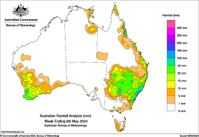
Weekly totals greater than 100mm were recorded in parts of the Hunter and Illawarra districts.
Weekly totals of 50-100mm were recorded along large parts of the NSW coast extending inland, and in pockets of the state’s interior and north Qld’s coast.
Totals of 15-50mm were recorded across most of NSW, areas of southern and coastal Qld and south-western WA.
The highest weekly total at a Bureau gauge was 241mm at Swansea, NSW.
The highest daily rainfall during the week at a Bureau gauge was 155mm at Jervis Bay Airfield, NSW to 9am on May 5.