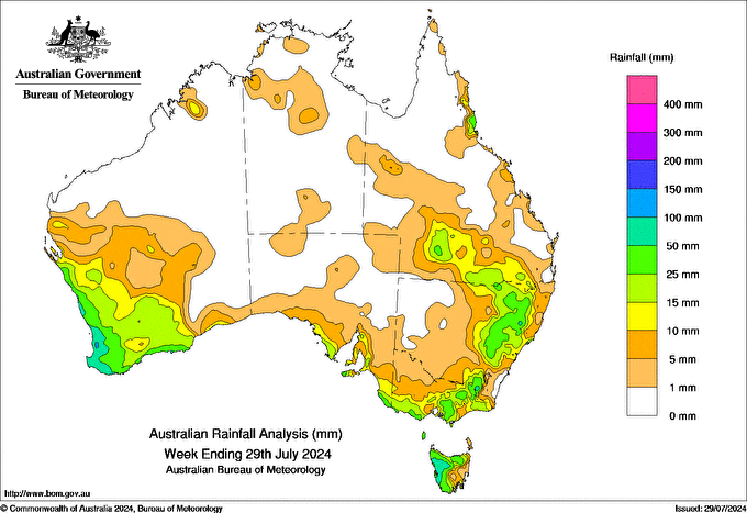
A COLD front crossed the south of Western Australia on 22 July bringing isolated thunderstorms, heavy rainfall and local flash flooding. In the 24 hours to 9 am on 23 July, 25 to 50 mm was recorded across the South West, Lower West and Great Southern districts, with isolated falls greater than 50 mm.
Over 24 to 25 July the system progressed over South Australia, Victoria, Tasmania and southern New South Wales, with the highest falls along the ranges. More cold fronts brought rainfall across the south-west and south-eastern states between 27 to 29 July, including a cold front on 29 July which brought 15 to 50 mm of rainfall to south-west Western Australia.
Over 27 to 28 July a cloudband brought rainfall to areas from the north-west of Australia across to New South Wales.
Onshore flow brought showers to coastal fringes of south-west Western Australia and east Queensland through the week.
South-west Western Australia recorded weekly totals between 5 and 50 mm across the region and between 50 and 100 mm along the west coast. South-eastern Australia had totals of 5 to 50 mm, mostly along the southern coast, the ranges and southern and coastal Queensland. Tasmania’s highest totals of 25 to 100 mm were recorded in the north and west.
Mount William in Western Australia, recorded the highest weekly total of 180.6 mm, as well as the highest daily rainfall total of 91.2 mm in the 24 hours to 9 am on 23 July.


