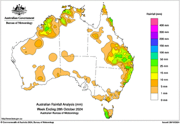
A low pressure trough combined with a humid airmass on 24 and 27 October, triggering widespread rainfall and locally severe thunderstorms with hail and strong winds, impacting southern, central and western Queensland and the northern and central coast of New South Wales.
Several cold fronts crossed south-eastern Australia, generating low to moderate rainfall totals, particularly in western Tasmania
A low pressure trough brought humid and showery conditions with isolated thunderstorms to some coastal and adjacent inland areas across northern Australia.
Weekly rainfall totals of 10 to 25 mm were recorded across the central and northern coasts of New South Wales, a large area of southern, central and western Queensland and parts of the north, the Top End of the Northern Territory and the Kimberley region of Western Australia.
Weekly rainfall totals of 25 to 50 mm were recorded across western Tasmania, isolated pockets of the central and northern coast of New South Wales, areas of southern, central and northern Queensland, isolated pockets of the Top End of the Northern Territory, and an area of Western Australia’s Kimberley district.
The highest weekly rainfall total (at a Bureau gauge) was 63.0 mm at Nearum Rd Alert in Queensland, recorded on a single day, in the 24 hours to 9 am on 25 October, making it also the highest daily rainfall total in the week.