SEVERE Tropical Cyclone Sean weakened off the coast of Western Australia during the week producing scattered showers, and storms around the north-west coast of Western Australia.
Cold fronts and associated troughs brought scattered showers and storms to Tasmania, Victoria, and severe storms associated with a southerly buster along eastern New South Wales and south-eastern Queensland.
Persistent low-pressure troughs through the interior, eastern states and Western Australia produced storms, some severe, and scattered rainfall in these regions.
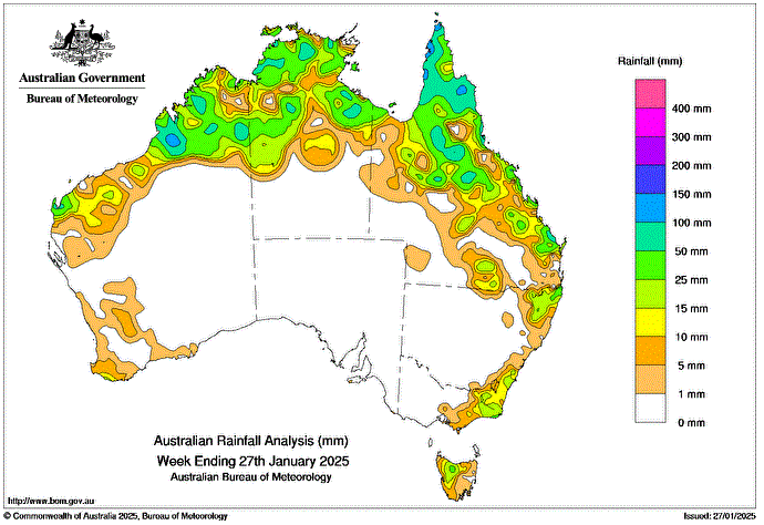
Weekly rainfall totals greater than 25 mm were recorded across parts of northern Western Australia, northern and central parts of the Northern Territory, Queensland’s north and east, north-eastern New South Wales, far eastern Victoria and north-western Tasmania.
Weekly rainfall totals of 50 to 100 mm were recorded in isolated parts of northern Western Australia, western and the Top End of the Northern Territory, and northern, eastern and central parts of Queensland.
Weekly rainfall totals greater than 100 mm were recorded in isolated regions of far northern Queensland and northern Western Australia.
The highest weekly total (at a Bureau gauge) was 134.4 mm at Scherger RAAF in Queensland.
The highest daily total (at a Bureau gauge) was 84.0 mm at Hawkins Creek in Queensland in the 24 hours to 9 am on 27 January.
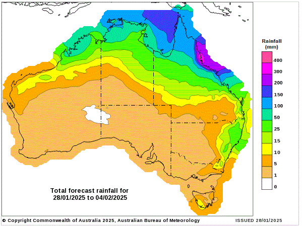
8 day Rainfall Forecast