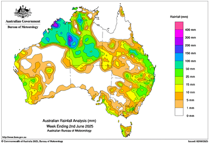
A low pressure trough and an upper disturbance over Western Australia’s north-west led to a north-west cloud band with widespread rain and scattered thunderstorms, some severe, over the northern parts of Western Australia and the Northern Territory, shifting as far south as Alice Springs during the week.
Weekly rainfall totals of 50 to 100 mm, with locally higher totals, were recorded across Western Australia’s north-west and large regions of the Northern Territory’s west, north and south.
Another low pressure trough and an upper disturbance triggered light to moderate rainfall across north-eastern New South Wales and central and south-eastern Queensland.
Weekly rainfall totals of 25 to 100 mm were recorded across regions of north-eastern New South Wales and central and south-eastern Queensland later in the week.
Cold fronts and associated low pressure troughs led to scattered rainfall and storms across south-west Western Australia, southern parts of South Australia, Victoria, Tasmania and eastern New South Wales.
Weekly rainfall totals of 15 to 50 mm were recorded over pockets of western and central Western Australia, parts of south-eastern South Australia, south-western Victoria and the ranges, and most of western Tasmania.
The highest confirmed weekly total (at a Bureau gauge) was 197.8 mm at Katherine – Cragborn Rd in the Northern Territory (data to 28 May), which included the highest confirmed daily total (at a Bureau gauge) of 197.8 mm in the 24 hours to 9 am on 28 May.
HAVE YOUR SAY