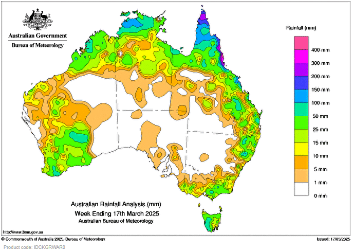
EARLY in the week, remnants of ex-Tropical Cyclone Alfred weakened into a low pressure trough that extended from south-eastern Queensland into northern New South Wales and brought widespread showers.
A strong cold front brought widespread showers and isolated thunderstorms to southern Western Australia, Tasmania and Victoria.
Low pressure troughs extending offshore across northern Australia, triggered showers and isolated thunderstorms over parts of western, southern and northern Australia during the week.
Weekly rainfall totals greater than 100 mm were recorded across parts of the Top End of the Northern Territory and northern Queensland, with areas of the tropical north-east coast in Queensland recording falls greater than 200 mm.
Weekly rainfall totals between 50 to 100 mm were recorded across the Top End of the Northern Territory, large parts of northern Queensland and areas of central and southern Queensland, areas of north-eastern New South Wales, eastern Victoria, western Tasmania and Western Australia’s north-west and south-west coasts and the southern interior.
Weekly rainfall totals between 25 to 50 mm were recorded across eastern Victoria, most of Tasmania and large parts of northern and southern Western Australia.
The highest weekly total (at a Bureau gauge) was 627.0 mm at Mt Sophia in Queensland, which included the highest daily total of 255.0 mm in the 24 hours to 9 am on 16 March.
HAVE YOUR SAY