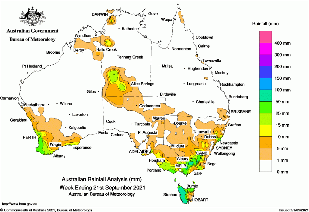
RAINFALL during the past week was largely confined to the south west and south east corners of the Australian continent, with additional falls in north-western and southern parts of the Northern Territory.
A cold front early in the week brought moderate falls to the west coast of Western Australia, and light falls over the South West Land Division, before moving eastwards to produce moderate falls for western Tasmania, north-east Victoria and inland south-eastern New South Wales.
Another cold front that followed later in the week brought further moderate falls to the same areas.
Past seven days: For the week to 21 September 2021, rainfall was recorded in south-west Western Australia, in north-western and southern parts of the Northern Territory, far south-east South Australia, southern and north-eastern Victoria, northern and western Tasmania, and eastern New South Wales.
At the start of the week, a low pressure system well off the New South Wales north coast generated moderate falls over the Mid North Coast and Hunter districts. Isolated thunderstorms developed near a surface trough, and produced moderate falls over some parts of the north-west Top End in the Northern Territory.
A cold front tracked across south-west Western Australia, generating showers and thunderstorms, with moderate falls over the west coast of Western Australia, and light falls over the South West Land Division. A cloudband extended from northern Western Australia, through Central Australia to south-east Australia, with showers and thunderstorms producing light to moderate falls in parts of the Kimberley and southern parts of the Northern Territory.
The cold front, a pre-frontal trough and associated cloudband moved over eastern Australia, and generated moderate falls over western Tasmania, north-east Victoria and inland south-eastern New South Wales, while elevated parts of the Snowy Mountains recorded daily falls of 40-50 mm. Light falls were recorded across eastern New South Wales and southern Victoria.
In the last part of the week, another cold front brushed the southern coast of Western Australia, generating light falls in south-west Western Australia. The cold front tracked eastwards across south-east Australia, and generated moderate falls in western Tasmania, southern and north-eastern Victoria, and the Snowy Mountains in New South Wales, with light falls across south-east South Australia and remaining parts of Victoria and Tasmania.
Rainfall totals in excess of 50 mm were recorded in western Tasmania, north-eastern Victoria, and the Snowy Mountains and central coast in New South Wales. Perisher Valley in the Snowy Mountains recorded the highest weekly rainfall total of 132 mm.
Rainfall totals between 10 mm and 50 mm were recorded in south-west Western Australia; north-western and southern parts of the Northern Territory; far south-east South Australia; southern, central and north-east Victoria. Similar totals were recorded in much of eastern New South Wales, and in northern and western Tasmania.
Highest weekly totals list and map
New South Wales and Australian Capital Territory
132 mm Perisher Valley AWS
84 mm Careys Peak (Barrington Tops)
74 mm Smiths Lake (Patsys Flat Road)
Victoria
92 mm Mount Hotham
91 mm Falls Creek
84 mm Mount Baw Baw
Queensland
12 mm Alva Beach
9 mm Maroon Dam
8 mm Oakey Aero
Western Australia
65 mm Mount William
62 mm Karnet
54 mm Karragullen North
South Australia
30 mm Willunga
24 mm Aldgate
23 mm Kuitpo Forest Reserve, Piccadilly (Woodhouse)
Tasmania
98 mm Lake Margaret Dam
89 mm Warra
83 mm Mount Read
Northern Territory
34 mm Marrara
27 mm Darwin Botanic Gardens
22 mm Darwin Airport
![]()