Thunderstorms and showers brought rain to he northern tropics and east of Australia, while Tropical Cyclone Anika moved over the north Kimberley coast.
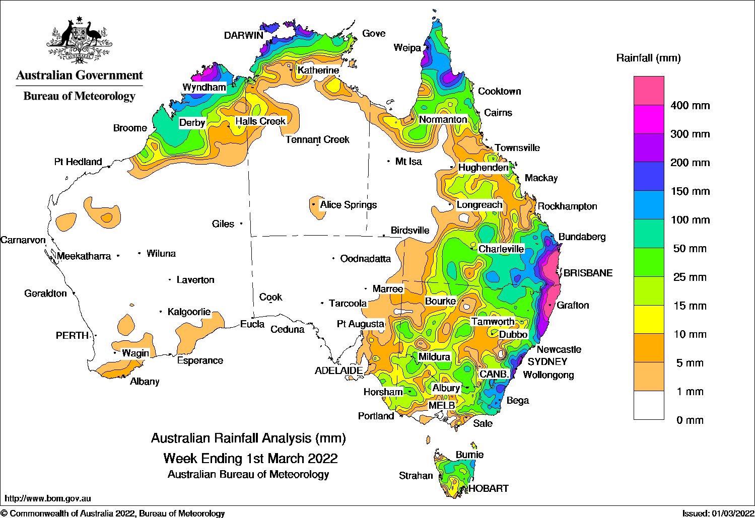
For the week to 1 March 2022, rainfall was recorded in the Kimberley, adjacent areas of Pilbara and in small areas in the south and west of Western Australia, in parts of the northern Northern Territory, most of Queensland away from North-West and parts of Channel Country Districts, in New South Wales, Victoria and adjacent parts of South Australia, and in Tasmania.
During the first part of the week a widespread thunderstorm activity over the northern tropics resulted in moderate to heavy rainfall across the Kimberley, Top End, Gulf of Carpentaria and Far North Queensland. A surface low pressure trough and an upper system generated thunderstorms in central to southeast Queensland, New South Wales and Victoria. Many locations in south-eastern Queensland and north-eastern New South Wales recorded daily rainfall totals of more than 100 mm, and locally much higher.
In the middle of the week, a monsoon trough with an associated tropical low developed over the Top End with embedded thunderstorms, while a trough that extended from the Top End over Cape York Peninsula into the Coral Sea brought thunderstorms to the Far North Queensland. A moist onshore wind flow and an upper level trough resulted in thunderstorm activity in eastern Queensland, New South Wales and eastern Victoria. Widespread moderate to heavy rainfall was recorded in eastern parts of central and southern Queensland, and eastern New South Wales and Victoria, with heaviest falls contracting to south-east Queensland and north-east New South Wales. To 9am on the 26th, the third-party gauges at Mt Glorious (north-west of Brisbane) and Pomona (south of Gympie) recorded 709.0 mm and 541.0 mm respectively.
In the last part of the week, tropical cyclone Anika formed over the Timor Sea and moved to the south-west over the north Kimberley coast. An active monsoon trough generated widespread rain and embedded thunderstorms over the Top End, Gulf of Carpentaria and northern parts of Cape York Peninsula, while a slow-moving middle and upper-level trough, combined with fresh and moist onshore winds and a surface trough, continued to generate persistent heavy rainfall in south-east Queensland and north-east New South Wales. To 9am on the 28th, Rosebank, in north-east New South Wales, recorded a daily rainfall total of 701.8 mm, the highest in the Bureau network in New South Wales since 1954. The nearby third-party gauge at Dunoon recorded a total of 775.0 mm.
Weekly rainfall totals in excess of 100 mm were recorded in northern parts of Kimberly, the Top End and Cape York Peninsula, in large parts of south-east Queensland and north-east New South Wales, and in central and southern coastal New South Wales. The highest weekly rainfall total in the Bureau network was 1346.0 mm at Uki on the Tweed River in north-east New South Wales.
Rainfall totals between 50 mm and 100 mm were recorded in north-west Kimberley and parts of the Top End and Cape York Peninsula, in large area in south-east Queensland, and in parts of coastal New South Wales.
Apart from surrounding higher falls, rainfall totals between 10 and 50 mm were recorded in parts of central Queensland, in large areas in central and southern New South Wales; in parts of Victoria and the far south-east South Australia; and in most of northern Tasmania.
Weekly rainfall totals map
Highest weekly totals
New South Wales and Australian Capital Territory
1346 mmUki (Tweed River)
1170 mmKunghur (The Junction)
1091 mmRosebank (Repentance Creek)
Victoria
148 mmCombienbar Aws
89 mmGelantipy
64 mmWodongaGabo Island Lighthouse
Queensland
1097 mmClontarf
1009 mmAlderley
969 mmRedcliffe
Western Australia
408 mmTruscott
332 mmKalumburu
220 mmTheda
South Australia
59 mmFrances
39 mmTanunda
30 mmGomersal (Woodbridge)Loxton Research Centre
Tasmania
203 mmGray (Dalmayne Rd)
173 mmLarapuna (Eddystone Point)
123 mmSt Helens Aerodrome
Northern Territory
487 mmDum In Mirrie Airstrip
321 mmGeriatric Park
236 mmWarruwi Airport
These rainfall totals are based on real-time rainfall reports, and only limited quality control has been performed on the data. Some station names have been shortened by taking away words such as post office and airport.