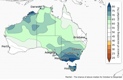

 October rainfall is likely to be above average across northern and eastern Australia, according to the Bureau of Meteorology’s latest three monthly seasonal climate outlook statement issued this morning.
The strongest chances of above average rainfall are in Victoria, Tasmania and southern NSW.
A small area in southern WA shows an increased chance of a drier month.
October to December rainfall is also likely to be wetter than average for much of the country, except in the northeast and southwest where the chances of a wetter or drier than average three months are roughly equal.
The current outlook reflects a negative Indian Ocean Dipole, warmer than average ocean temperatures surrounding northern Australia and an ENSO-neutral tropical Pacific, showing some La Niña-like characteristics.
The Bureau says historical outlook accuracy for October to December is “moderate to high” over most of Australia.
The current negative Indian Ocean Dipole (IOD) pattern is expected to remain strong in October but return to neutral by the end of spring, consistent with the typical IOD cycle.
El Niño–Southern Oscillation (ENSO) remains neutral, however warmer than normal sea surface temperatures to Australia’s north and east (often typical of a La Niña pattern) may be contributing to some La Niña-like impacts in Australia. Some atmospheric indicators of La Niña have strengthened in September.
This combination of climate drivers (all of which on their own tend to enhance rainfall in parts of Australia) is contributing to the increased chances of above average rainfall in this outlook, and has been a major influence on recent Australian climate that has seen above average and record rainfall across much of Australia since May.
In addition to the shorter-term natural drivers, Australian climate patterns are being influenced by the long-term increasing trend in global air and ocean temperatures.
Cooler season likely for most of Australia
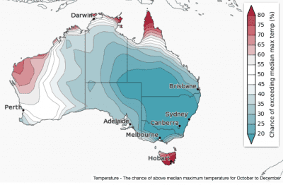
October to December days are likely to be cooler than average for most of Australia. In the northern tropics, western WA and Tasmania, daytime temperatures are likely to be warmer than average.
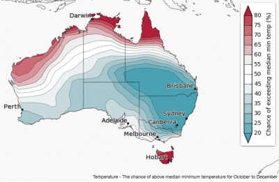
Overnight temperatures show a similar pattern to the daytime temperatures: cooler than average except in the northern tropics, parts of western WA and Tasmania where nights are likely to be warmer than average.
The current outlook reflects a negative Indian Ocean Dipole, warmer than average ocean temperatures surrounding northern Australia and an ENSO-neutral tropical Pacific, showing some La Niña-like characteristics.
Maximum temperature accuracy is moderate to very high over most of Australia, except for a small area in WA where accuracy is low to very low. Minimum temperature accuracy is moderate over much of the country but patchy along parts of the east coast and the northern tropics.
Source: Bureau of Meteorology
