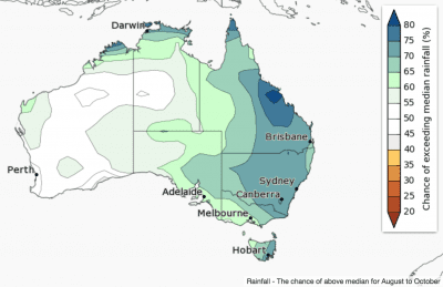
Rainfall in August to October is likely to be above average across eastern and northern Australia, according to the Bureau of Meteorology’s latest three month outlook.
The western half of Australia has roughly equal chances of a wetter or drier three months.
 August is likely to be wetter for eastern and northern Australia.
The current outlook reflects a strong negative Indian Ocean Dipole, a continued cooling of tropical Pacific Ocean waters, and very warm sea surface temperatures surrounding northern and eastern Australia.
Historical outlook accuracy for August to October is moderate over most of Australia, but low in parts of central Queensland and interior WA.
Warmer days likely for the northwest and Tasmania; cooler in the east
For August to October, warmer than average days are more likely for Tasmania and the tropical north extending down into northwestern WA. Cooler days are more likely in the east, and southern parts of WA.
Night-time temperatures are more likely to be warmer across northern and central Australia, and the far southeast. Parts of southeast Queensland and northeast NSW are more likely to have cooler than average nights for August to October.
Historical maximum temperature accuracy for August to October is moderate over the southern half of mainland Australia, Queensland and the Top End of the NT. Elsewhere, accuracy is low. Minimum temperature accuracy is moderate over northern Australia, parts of SA, northern NSW, and Tasmania, but low elsewhere.
