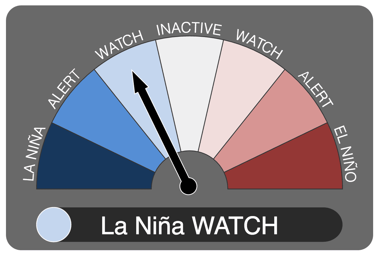
The Bureau of Meteorology’s ENSO watch indicator has now moved to the “La Nina Watch” phase.
The so-called “Godzilla” El Nino weather pattern largely responsible for causing another year of low rainfall and high temperatures across large parts of Australia already wracked by long-running drought has finally run out of puff.
The Bureau of Meteorology has announced that cooler sea surface temperatures over the past fortnight, and much cooler-than-average waters beneath the surface, means the El Nino-Southern Oscillation (ENSO) index has now returned to a neutral state.
“Outlooks suggest little chance of returning to El Niño levels, in which case mid-May will mark the end of the 2015–16 El Niño,” the Bureau confirmed yesterday.
Prospects of La Nina strenghtening
At the same time, the significant recent cooling measured in the tropical Pacific Ocean points to a possible moisture-bearing La Nina pattern developing around Australia soon.
The Bureau notes that six of eight models currently support the formation of a La Nina pattern during the ‘Austral winter’ (June–August).
However the Bureau also notes that individual model outlooks “show a large spread between neutral and La Niña scenarios”.
“Changes in the tropical Pacific Ocean and atmosphere, combined with current climate model outlooks, suggest the likelihood of La Niña forming later in 2016 is around 50%, meaning the Bureau’s ENSO Outlook remains at La Niña WATCH,” the Bureau says in its latest fortnightly ENSO statement, issued yesterday.
Typically during La Niña, winter-spring rainfall is above average over northern, central and eastern Australia.
Climate model outlooks for the Indian Ocean Dipole (IOD) suggest a negative IOD event is likely to develop during the austral winter.
However, outlook accuracy for the IOD at this time of year is low. A negative IOD typically brings increased winter-spring rainfall to southern Australia.
Weather watchers Higgins Storm Chasing says on its popular Facebook page that should forecasts of a La Nina come to fruition, there is a good chance that rainfall through Northern and Eastern Australia will greatly increase to above average through the second half of 2016 well into 2017.
“Tropical Low and Tropical Cyclone numbers are also likely to increase during a La Nina event,” the site says.
“Adding to the equation is the forecast for negative Indian Ocean Dipole conditions to develop from June 2016 until January 2017.
“Again this often increases heavy rainfall over Australia due to increased moisture being fed in from the North West. The last time Australia experienced a La Nina and negative IOD event together was in 2010 / 2011.”
Max Gonzales from Weatherzone also notes that most of the “more accurate” international climate models suggest the recent cooling will continue over the coming months with most exceeding La Nina thresholds by September 2016.
“The good news, mainly for our agriculture, is that La Nina usually brings above average rainfall over the northern and eastern half of the country during late winter and spring. Warmer than average sea surface temperatures are surrounding the majority of Australia’s coast, increasing the chances of above average rainfall by providing moisture to the atmosphere.
“Moreover, most International models are also forecasting a negative phase of the Indian Ocean Dipole or IOD. This index is based off the relative difference between sea surface temperatures across two areas in the Indian Ocean. An IOD event usually starts around May or June, peaks between August and October and then rapidly decays affecting Australia mainly in late winter and through spring.
“Negative phases of the IOD tend to bring above average rainfall to southeastern Australia and therefore can reinforce the above average rainfall usually seen during La Nina years.
The last year we saw an El Nino heading into a La Nina with also a negative IOD was in 2010.”
Back then, below average temperatures were observed over central and southern Australia, west of the Great Dividing Ranges during winter. Above average rainfall was also observed during this period over most of WA and the NT, SA, VIC, southeastern NSW and TAS. The 2010-2011 La Nina then went on to be one of the strongest on records leading to the QLD and VIC floods.
However, not every La Nina is the same and so its effects are varied across our country. The relationship between La Nina and the IOD is complicated, with the level of dependence of the two phenomena an area of active research. Nevertheless, the combination of a negative IOD and La Nina conditions has historically increased the likelihood of heavy rainfall across Australia.