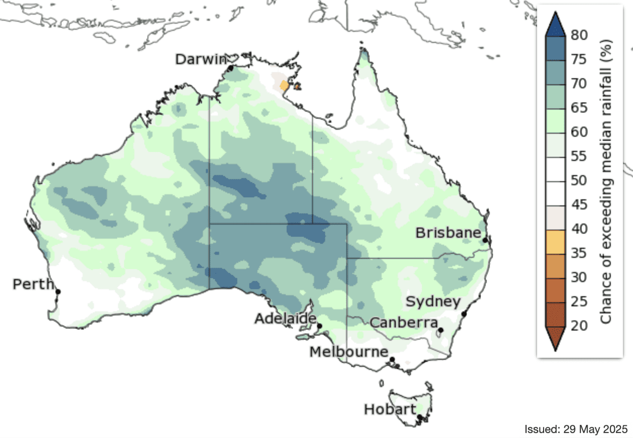
WINTER rainfall is likely to be above average for interior and central parts of the country, according to the Bureau of Meteorology’s long-range forecast for winter 2025.
For parts of Australia’s tropical north, the south-east and the south-west, rainfall is expected to be in the typical winter range. Typical rainfall means there’s a roughly equal possibility for these areas to receive above, below or near-average rainfall.
This includes parts of South Australia, Victoria and Tasmania that have been affected by prolonged dry conditions as well as parts of New South Wales recently impacted by severe flooding.
This winter forecast follows an autumn which was much wetter than average in the north and east of Australia, and much drier than average in many southern parts.
Australia’s fire agencies advise there is an unseasonal increased risk of fire this winter across parts of South Australia and Victoria.
The Bureau updates the long-range forecast each Thursday and you can search the latest details for your location on the Bureau’s website.
Winter long-range forecasts:
New South Wales and the ACT
Winter rainfall is expected to be above average for much of the state and the ACT.
However, parts of the state’s east are likely to have rainfall in the typical range.
Average winter rainfall in recent decades has been between 100 and 300 mm along most of eastern New South Wales, with higher falls in the alpine regions, while in western and central New South Wales winter averages are between 25 and 100 mm.
Warmer than usual winter maximum temperatures are likely across the state, and warmer than usual winter minimum temperatures are very likely.
Victoria
Rainfall is expected to be within the typical winter range for much of the state.
Average winter rainfall in recent decades ranges between 100 and 300 mm throughout much of the state, while the state’s north-west has 50 to 100 mm and parts of the far south and alpine areas have up to 600 mm on average
Warmer than usual winter maximum and minimum temperatures are very likely across the state.
Queensland
Winter rainfall is expected to be in the typical range for much of the state, with parts of the south and west likely to have above average rainfall.
Warmer than usual winter maximum and minimum temperatures are very likely across the state.
Western Australia
Winter rainfall is expected to be above average for much of the state, except for the south-west where rainfall is likely to be in the typical winter range.
Average winter rainfall in recent decades has been between 100 and 400 mm for most of the South West Land Division with up to 600 mm in the far south-west, 50 to 100 mm in parts of the west, central and south-east, between 25 and 50 mm mid-state, and less than 10 mm in the north.
Warmer than usual maximum and minimum winter temperatures are very likely across the state.
South Australia
Winter rainfall is likely to be above average for much of the state, except for the far south-east where rainfall is expected to be within the typical range for winter.
Average winter rainfall in recent decades has been between 50 and 300 mm across the south with some coastal parts up to 400 mm, and 10 to 50 mm for the central and northern parts.
Warmer than usual winter maximum and minimum temperatures are likely across the state.
Tasmania
Winter rainfall is expected to be in the typical range for much of the state.
Warmer than usual winter maximum and minimum temperatures are very likely across the state.
Northern Territory
Winter rainfall is likely to be above average across the southern two-thirds of the Territory.
Warmer than usual June to August maximum and minimum temperatures are very likely across most of the Territory.
Autumn Preliminary Summary
Autumn has been warmer than usual for most of Australia. Throughout much of the south and west, daytime temperatures were very much above average.
Victoria had its warmest autumn on record, New South Wales had its second warmest, and South Australia and Western Australia had their third warmest autumn on record. Autumn has been drier than average across much of the country’s south and west.
Slow-moving high pressure systems to the south of the continent are contributing to drier conditions in the south. This pattern has also enhanced coastal troughs off New South Wales and southern Queensland, contributing to the recent above average coastal rainfall in these states.
Conditions have been wetter than usual for much of the east and north, with rainfall very much above average in large parts of Queensland.
Tropical activity, including Tropical Cyclone Alfred and a low pressure trough over western Queensland, brought widespread rainfall and flooding during March and April.
Autumn rainfall was very much below average in large parts of the south-east and the west coast. In Tasmania, autumn rainfall was the second lowest on record.
The national summary for autumn and May will be on the Bureau’s website from 2 June. Detailed summaries for autumn and May conditions for each state, territory and capital city will be published on 4 June.
Source: Bureau of Meteorology
HAVE YOUR SAY