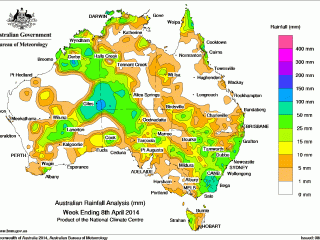
Rain was recorded in all states and territories for the week to 9am Tuesday, with the biggest falls (50mm plus) recorded in parts of the Snowy Mountains, the NSW South Coast, Victoria’s Gippsland, West Kimberley, areas around the Western Australia-Northern Territory border and the Northwest Pastoral district of South Australia.
 At the beginning of the week, a cloud band extended over parts of Western Australia and southern South Australia, associated with a vigorous cold front and an inland trough located over Western Australia.
Another surface trough extended from the Kimberley, through the Northern Territory, southwestern Queensland, into New South Wales and down to the Tasman Sea generated some showers and storm activity with some locally heavy falls.
A cold front and upper level trough moved through southern Australia, producing a band of rain and isolated thunderstorms across the Pastoral and Flinders districts in South Australia.
Mid-week, a low pressure system in the North Kimberley and Darwin-Daly districts linked to a near stationary surface trough extending from the northwest Kimberley through the Pilbara.
A tropical low lying to the southwest of the Solomon Islands early on the 5th deepened during the day and was named tropical cyclone Ita around 11pm (AEST), and the system moved slowly westwards but remaining well offshore of the Queensland coast.
By the week's end, an inland trough in Western Australia interacted with a middle level disturbance to produce thunderstorms across much of the southern half of Western Australia, with the outflow from tropical cyclone Ivanoe, which was well west of Western Australia, feeding into this system.
A large area of shower and thunderstorm activity continued over the Coral Sea in association with tropical cyclone Ita.
A large cloud band stretching from the northwest of the country to the southeast was slowly developing, with surface troughs extending from northern Western Australia through the Australian interior bringing some heavy falls. Another large cloudband along the west coast of Western Australia was due to ex-tropical cyclone Ivanoewas evident as it underwent transition to an extra-tropical low.
Weekly rainfall totals of over 100 mm were recorded in parts of the Snowy Mountains, West Kimberley and around the Western Australia-Northern Territory border. Yarras (Mount Seaview) recorded the highest weekly total of 143 mm.
Totals between 50 to 100 mm were recorded in the northeast of the Southern Interior district of Western Australia, the southwest of the Victoria River district in the Northern Territory and the Northwest Pastoral district of South Australia as well as the South Coast and Snowy River districts in New South Wales extending into East Gippsland in Victoria.
Falls between 15 to 50 mm were recorded in northern Australia including the northeast tropical coast, as well as extending from the West Kimberley region through the central interior of Australia and northern South Australia, and into New South Wales covering most of the south east Australian coast, including western Tasmania.
Much of the central coast of Western Australia, eastern Northern Territory and through the central interior of Queensland, and parts of South Australian-Western Australian border and western Victoria recorded little or no rainfall throughout the week.
Highest rainfall totals for each state:
| WA |
Giles (103 mm) (Northeast) |
Bedford Downs (73 mm) (East Kimberley) |
Doongan (68 mm) (North Kimberley) |
| NT |
Walungurru (91 mm) (Alice Springs) |
Pirlangimpi (89 mm) (Darwin-Daly) |
Geriatric Park (86 mm) (Darwin-Daly) |
| SA |
Tieyon (63 mm) (Northwest) |
Todmorden (47 mm) (Northwest) |
Ernabella (Pukatja) (39 mm) (Northwest) |
| Qld |
Mornington Island Airport (73 mm) (Lower Carpentaria) |
Low Isles (63 mm) (Barron North Coast) |
Lockhart River (59 mm) (South Peninsula) |
| NSW/ACT |
Yarras (Mount Seaview) (143 mm) (Manning) |
Careys Peak (107 mm) (Hunter) |
Perisher Valley (88 mm) (Snowy Mountains) |
| Vic |
Combienbar (102 mm) (Lower Northeast) |
Gabo Island Lighthouse (91 mm) (Lower Northeast) |
Reeves Knob (80 mm) (West Gippsland) |
| Tas |
Mount Read (30 mm) (West Coast) |
Lake Margaret (27 mm) (West Coast) |
Queenstown (26 mm) (West Coast) |
Source: BOM
Click on below map to view in large format: