 As northern Australia remains in the grip of one of its driest wet seasons on record, all eyes are focusing on a forecast build-up in monsoonal activity that could bring much-needed seasonal relief in the next fortnight.
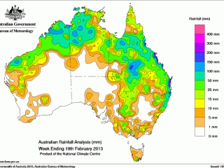
Some timely deluges have been recorded in parts of western Queensland and northern Australia in the past five days, but many have still missed the rain they need to replenish surface water and trigger grass growth.
The best of the falls were recorded in Queensland’s central west, where measurements included around 250mm (10 inches) at Ilfracombe, 100-150mm (4-6 inches) around Longreach and Muttaburra, 75mm (3 inches) around Winton and 50mm (2 inches) round Aramac, Jundah and Stonehenge.
Further north falls in the vicinity of 25mm were measured around Richmond and Julia Creek, and extended further north into the Gulf and east towards Charters Towers and the coast.
At Longreach, Bill Seeney of Ray White Rural said the rain was “beautiful” where it fell.
“It is not the season done and dusted, but it is a big, big help,” Mr Seeney said.
“It takes the pressure off locally, but there is still a lot of dry country about – Cloncurry, Mount Isa, and Blackall and Barcaldine – which still needs a lot more rain yet.”
Further north at Richmond, Luke Westaway of TopX said the rain had eased a small amount of pressure off forced sales where it fell, but follow-up would still be needed within two-weeks to generate grass growth.
“At this point I think you could say that the northern area is happy to receive a bit of relief but certainly it has not been the amount required,” Mr Westaway said.
“It is not going to produce major growth, but it will keep the existing shoots and seedlings alive as we wait and hope for a bigger deluge in time.”
The wet weather has forced the cancellation of the Longreach, Blackall and Charters Towers cattle sales this week, which will also lift some supply pressure off the northern cattle market.
Mr Westaway said that “all eyes are now on the sky” to see what the next fortnight brings, with particular emphasis on the next wave of the Madden-Julian Oscillation (MJO), due in the next fortnight.
“The MJO for the start of March is what we’re all focused on now, everyone is expecting some influence to come through at that time, and that is what we’re really hoping for.”
MJO Mojo
 The MJO refers to the pulses of monsoonal cloud and rainfall that travel around the equator every 30 to 60 days.
Tropical cyclones are more likely to develop in association with certain phases of a strong MJO event, and, with the MJO now in Australian longitudes, fingers are being crossed that its current passage will deliver a significant rain event toward the end of February.
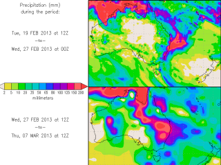
Longer term precipitation forecasts, such as the one pictured left from the Center for Ocean-Land-Atmosphere Studies, which shows potentially significant rain across northern and eastern Australia and parts of WA next week, are fuelling hopes that a much-needed break will arrive while the grass-growing window is still open.
The Bureau of Meteorology ‘s latest weekly tropical cyclone note, issued yesterday, carries mixed forecasts.
It says the next burst in monsoonal activity across the Top End may be “short-lived”, however, a low pressure system over the Timor Sea this week could bring heavy rainfall to northern Western Australia, while the potential also exists for a low to develop over south east Queensland which could also bring heavy falls.
It notes that the MJO is expected to weaken and stall which could provide rainfall opportunities for north eastern Australia into March.
“Should the current MJO pulse persist, northeast Australia, the Coral Sea and southwest Pacific islands can expect more active weather, including heavy rainfall and an increased risk of tropical cyclone formation during the first few weeks of March.”