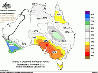
 The national rainfall outlook for September to November, released today, points to a drier than normal season for large parts of southeast and northeast Australia, and a wetter than normal season for southwest Western Australia and south west Queensland.
The Bureau of Meteorology attributes the outlook to emerging warmer than normal waters in the tropical Pacific Ocean and persistent warmer than normal waters in the Indian Ocean.
The Pacific Ocean is currently near the threshold for El Nino conditions.
Climate models forecast the Pacific to either exceed or remain just below El Niño thresholds during spring 2012. No models suggest a return to La Niña.
Regardless of whether an El Niño event develops, the Bureau says Australian climate drivers for spring 2012 “favour drier and warmer than average conditions”.
The chances of receiving above median rainfall during spring are higher than 60pc over most of the Southwest Land Division in WA and parts of southwest Queensland.
Probabilities exceed 70pc over a large part of the Southwest Land Division.
Such odds mean that for every ten years with similar ocean patterns to those currently observed, about six to seven years would be expected to be wetter than average over these areas, while about three to four years would be drier.
In contrast, the chances of receiving above normal rainfall are between 25 and 40pc over most of southern SA, southern NSW, Victoria, northern and eastern Tasmania, and northern Queensland.
In other words the chances of below normal rainfall are between 60 and 75pc, according to the Bureau.
Over the rest of the country, the chances of a drier or wetter spring are roughly equal.
Temperature outlook
The national outlook averaged over spring 2012 suggests that warmer days are more likely over northern and eastern Australia and warmer nights are more likely over most of Australia.
This outlook is mostly a result of persistent warmer than normal waters in the Indian Ocean; emerging warmer than normal Pacific waters have had a lesser impact.
The chances that the average spring maximum temperature will exceed the long-term median maximum temperature are above 60pc over the northern Kimberley in WA, the northern and central NT, eastern SA, and the four eastern States.
Probabilities rise above 75pc over the eastern Top End of the NT and parts of the Cape York Peninsula in Queensland.
This means that for every ten years with ocean patterns like the current, about six to eight spring periods would be expected to be warmer than average over these areas, with about two to four being cooler than average.
The chances that the average minimum temperature for spring will exceed the long-term median minimum temperature are above 60pc over most of Australia, with the exception of the southern two-thirds of Queensland and the northeastern half of NSW. Probabilities exceed 80% over part of inland southern WA, as well as an area near the WA-NT border.
History shows the oceans' effect on minimum temperatures during spring to be moderately consistent over most of Australia, with the exception of southeastern Australia, where the skill is only weakly to very weakly consistent.
